FAA INFORMATION EFFECTIVE 14 MAY 2026
Location
| FAA Identifier: | LHW |
| Lat/Long: | 31-53-16.1500N 081-33-45.5580W
31-53.269167N 081-33.759300W
31.8878194,-81.5626550
(estimated) |
| Elevation: | 46.6 ft. / 14.2 m (surveyed) |
| Variation: | 04W (1985) |
| Time zone: | UTC -4 (UTC -5 during Standard Time) |
| Zip code: | 31313 |
Airport Operations
| Airport use: | Open to the public |
| Control tower: | yes |
| ARTCC: | JACKSONVILLE CENTER |
| FSS: | MACON FLIGHT SERVICE STATION |
| NOTAMs facility: | LHW (NOTAM-D service available) |
| Attendance: | MON-FRI 0600-2300
TWR WILL OPEN FOR JOSAC MISSIONS, DSN 435-3103. WHEN BASE OPS CLSD, CTC HUNTER BASE OPS DSN 729-5110, SEE FLIP AP/1 FLT HAZ AND SUPPLEMENTARY ARPT RMK. |
| Wind indicator: | lighted |
| Segmented circle: | yes |
| Lights: | WHEN ATCT & MARNE RDO BOTH CLSD, ACTVT PAPI RWY 06L & 33R; HIRL RWY 06L/24R & 15L/33R; TWY A, B, C, & F - CTAF. |
| Beacon: | white-white-green (lighted military airport)
Operates sunset to sunrise. |
Airport Communications
| CTAF: | 126.25 |
| ATIS: | 118.475 |
| WRIGHT GROUND: | 121.7 273.575 [1230-0400Z++ M-F, EXCEPT HOLIDAYS.] |
| WRIGHT TOWER: | 126.25 269.275 [1230-0400Z++ M-F, EXCEPT HOLIDAYS.] |
| SAVANNAH APPROACH: | 120.4 |
| SAVANNAH DEPARTURE: | 120.4 |
| BASE OPS: | 140.55 372.125 |
| EMERG: | 243.0 |
| FLT FLW: | 127.35 279.625 41.3FM |
| GCA: | 134.65 280.9 |
| OPS: | 127.35 ;MARNE RDO 279.625 ;MARNE RDO 41.3FM ;MARNE RDO |
| PMSV METRO: | 252.025 |
| PTD: | 140.55 372.125 |
- WRIGHT FLIGHT FOLLOWING: CALL-VICTORY.
- VFR ADVISORY SVC OPERATES 0600-2400 MON-FRI EXC HOL.
- APCH/DEP SVC PRVDD BY JACKSONVILLE ARTCC ON FREQS 132.925/363.2 (SAVANNAH RCAG) WHEN SAVANNAH APCH CTL CLSD.
- OPR H24.
- TWR WILL OPEN FOR JOSAC MISSIONS. DSN 435-3103. WHEN BASE OPS CLSD, CTC HUNTER BASE OPS C571-801-8259/60. SEE FLIP AP/1 FLT HAZ AND SUPPLEMENTARY ARPT RMK.
Nearby radio navigation aids
| VOR radial/distance | | VOR name | | Freq | | Var |
|---|
| SVNr253/22.7 | | HUNTER VOR/DME | | 111.60 | | 02W |
| SAVr236/24.1 | | SAVANNAH VORTAC | | 115.95 | | 06W |
| NDB name | | Hdg/Dist | | Freq | | Var | | ID |
|---|
| BULLO | | 176/32.1 | | 407 | | 05W | | BZQ | -... --.. --.- |
Airport Services
| Fuel available: | 100LL JET-A+ |
| Parking: | tiedowns |
| Airframe service: | NONE |
| Powerplant service: | NONE |
| Bottled oxygen: | NONE |
| Bulk oxygen: | NONE |
Runway Information
Runway 6L/24R
| Dimensions: | 6500 x 100 ft. / 1981 x 30 m |
| Surface: | asphalt, in good condition |
| Weight bearing capacity: | |
| Runway edge lights: | high intensity |
| RUNWAY 6L | | RUNWAY 24R |
| Latitude: | 31-52.897747N | | 31-53.578732N |
| Longitude: | 081-34.496965W | | 081-33.526627W |
| Elevation: | 45.7 ft. | | 33.5 ft. |
| Traffic pattern: | right
RIGHT TFC RWY 06L CATS B C D & E. | | left |
| Runway heading: | 055 magnetic, 051 true | | 235 magnetic, 231 true |
| Markings: | nonprecision, in fair condition | | nonprecision, in fair condition |
| Visual slope indicator: | 4-light PAPI on left (3.00 degrees glide path) | | |
| Touchdown point: | yes, no lights | | yes, no lights |
| Obstructions: | 113 ft. trees, 2745 ft. from runway, 610 ft. right of centerline, 22:1 slope to clear | | none |
Runway 15L/33R
| Dimensions: | 5001 x 100 ft. / 1524 x 30 m |
| Surface: | asphalt, in excellent condition |
| Weight bearing capacity: | |
| Runway edge lights: | high intensity |
| RUNWAY 15L | | RUNWAY 33R |
| Latitude: | 31-53.662002N | | 31-53.024860N |
| Longitude: | 081-33.818767W | | 081-33.204707W |
| Elevation: | 37.3 ft. | | 33.2 ft. |
| Traffic pattern: | left | | left |
| Runway heading: | 145 magnetic, 141 true | | 325 magnetic, 321 true |
| Markings: | nonprecision, in fair condition | | nonprecision, in fair condition |
| Visual slope indicator: | | | 4-light PAPI on left (3.00 degrees glide path) |
| Touchdown point: | yes, no lights | | yes, no lights |
| Obstructions: | none | | 81 ft. trees, 2438 ft. from runway, 551 ft. right of centerline, 27:1 slope to clear |
Runway 6R/24L
| Dimensions: | 2610 x 100 ft. / 796 x 30 m |
| Surface: | asphalt, in poor condition |
| Runway edge markings: | RWY 6R/24L MARKINGS BADLY FADED. |
| Operational restrictions: | RWY 6R/24L CLSD INDEFLY. |
| RUNWAY 6R | | RUNWAY 24L |
| Latitude: | 31-53.118403N | | 31-53.391922N |
| Longitude: | 081-34.060673W | | 081-33.671218W |
| Elevation: | 41.1 ft. | | 39.0 ft. |
| Traffic pattern: | left | | left |
| Runway heading: | 055 magnetic, 051 true | | 235 magnetic, 231 true |
| Markings: | basic, in poor condition | | basic, in poor condition |
| Touchdown point: | yes, no lights | | yes, no lights |
Runway 15R/33L
| Dimensions: | 2520 x 100 ft. / 768 x 30 m |
| Surface: | asphalt/L |
| Runway edge markings: | RWY 15R/33L MARKINGS BADLY FADED. |
| Operational restrictions: | RWY 15R/33L CLSD INDEFLY. |
| RUNWAY 15R | | RUNWAY 33L |
| Latitude: | 31-53.376317N | | 31-53.055505N |
| Longitude: | 081-33.643652W | | 081-33.334042W |
| Elevation: | 38.3 ft. | | 31.6 ft. |
| Traffic pattern: | left | | left |
| Runway heading: | 145 magnetic, 141 true | | 325 magnetic, 321 true |
| Markings: | basic, in poor condition | | basic, in poor condition |
| Touchdown point: | yes, no lights | | yes, no lights |
Helipad H1
| Dimensions: | 50 x 50 ft. / 15 x 15 m |
| Surface: | turf, in fair condition |
| Latitude: | 31-53.174667N | | |
| Longitude: | 081-33.562833W | | |
| Elevation: | 41.0 ft. | | |
| Traffic pattern: | left | | left |
| Markings: | basic, in good condition | | |
Airport Ownership and Management from official FAA records
| Ownership: | U.S. Army |
| Owner: | US ARMY AERONAUTICAL SVCS AGENCY
FT BELVOIR, VA 22060 |
| Manager: | JESSE WILLETT
1116 E. LOWE CIRCLE
HINESVILLE, GA 31315
Phone (912) 435-3130 |
Additional Remarks
| - | FUEL: J8 AVBL FBO, C912-877-4359 (NC 100LL) 1300-0600Z++ MON-FRI, EXC HOL, OT 24 HR PPR. TRAN FUEL PPR, CTC BASE OPS 571-801-1579/1580. |
| - | CAUTION: EXTV R/W TRNG MIN LGT SS-SR. CTC TWR PRIOR TO ENTERING CLASS D AIRSPACE. R3005 1.4 NM NW OF AFLD. DEER AND PIG HAZ. |
| - | MISC: MOORING/TIE-DOWN STRAPS NOT AVBL. |
| - | RSTD: AVIATORS BRIEFED IN THE LAST 6 MOS MAY RECEIVE A TELEPHONIC UPDATE BRIEFING. CTC HUNTER AAF OPS C571-801-8263/64. 1200-0100Z++ MON-FRI. |
| - | CIVILIAN FBO PH#'S 912-877-4364 & 912877-4359. |
| - | UNMANNED ACFT ACT IN CLASS D. |
| - | MISC: FULL WX SVC EFF 1100-0400Z++MON-FRI, CLSD WEEKEND AND FEDERAL HOL, OT REMOTE BRIEFING FR 26 OWS BARKSDALE AFB, LA, DSN 331-2651/2/3, C318-529-2651/2/3. DUR PERIODS OF AUGMENT ATC WILL ASSIST IN COOPERATIVE WX WATCH BY NOTIFYING WX OF UNREPORTED COND. AUGMENTATION MODE, PREVAIL SFC VIS MAY NOT BE REPRESENTED OF ENTIRE AFLD DUE TO BLDG OBST AND LACK OF VIS. MARK BYD 1 1/2 SM. KLHW FCST 571-801-1585/86. |
| - | MISC: OPR HRS MAY VARY WITH LCL FLYING SHED. |
| - | COMM: CTAF MARNE RDO - OPR 1230Z++ MON-0400Z++ SAT, SUN 1230Z++ - 0400Z++ EXC HOL. MIDCOAST REGIONAL-FBO OPR 1200-0000Z++. 123.075. |
| - | MISC: MAIN RAMP PARKING PADS 15-18 PERM CLSD / SOUTHERN TAXI LANE PERM CLSD. |
| - | CAUTION: TWYS A, B, C SIGNS REMOVED OR U/S. TWY E PERM CLSD. |
| - | R/W ACFT PILOTS PLANNING TO CONDUCT OPR WITHIN R3005 MUST RCV A RNG BRIEFING PRIOR TO ANY OPR. BRIEFING SHALL BE ACCOMPLISHED AT LEAST 4 HRS PRIOR TO FLT ON THE RESERVATION. |
| - | CAUITON: RWY 33R/15L SIGNS REMOVED OR U/S. RWY 24R SIGNS REMOVED OR UNSERVICEABLE. |
| - | CAUTION: ALL DISTANCE REMAINING SIGNS MISSING FROM ALL RWYS. |
| - | MISC: NO OVERRUNS FOR RWY 24R, 15L/33R. |
| - | RSTD: ALL MIL PPR AND MIL TRAN ACFT, CTC BASE OPS 571-801-1579/1580. |
| - | NS ABTMT: NO OVFT OF CANTONMENT AREA OR CITY OF HINESVILLE BELOW 1000 FT AGL. |
| - | (CONTACT TITLE) OTR CTC: JESSE.A.WILLETT.CIV@ARMY.MIL |
Instrument Procedures
NOTE: All procedures below are presented as PDF files. If you need a reader for these files, you should download the free Adobe Reader.NOT FOR NAVIGATION. Please procure official charts for flight.
FAA instrument procedures published for use from 14 May 2026 at 0901Z to 11 June 2026 at 0900Z.
IAPs - Instrument Approach Procedures |
|---|
| RNAV (GPS) RWY 06L | |
download (242KB) |
| RNAV (GPS) RWY 33R | |
download (305KB) |
| NOTE: Special Alternate Minimums apply | |
download (160KB) |
| NOTE: Special Take-Off Minimums/Departure Procedures apply | |
download (424KB) |
Other nearby airports with instrument procedures:
KSVN - Hunter Army Airfield (22 nm E)
KSAV - Savannah/Hilton Head International Airport (23 nm NE)
KCWV - Claxton-Evans County Airport (24 nm NW)
KJES - Jesup-Wayne County Airport (26 nm SW)
KRVJ - Swinton Smith Field at Reidsville Municipal Airport (32 nm W)
|
|

Road maps at:
MapQuest
Bing
Google
| Aerial photo |
|---|
WARNING: Photo may not be current or correct

Do you have a better or more recent aerial photo of Wright Army Airfield (Fort Stewart)/Midcoast Regional Airport that you would like to share? If so, please send us your photo.
|
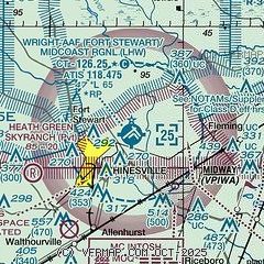
| Sectional chart |
|---|
|
CAUTION: Diagram may not be current
 Download PDF
of official airport diagram from the FAA
| Airport distance calculator |
|---|
|
|
| Sunrise and sunset |
|---|
|
Times for 21-May-2026
| | Local
(UTC-4) | | Zulu
(UTC) |
|---|
| Morning civil twilight | | 05:59 | | 09:59 |
| Sunrise | | 06:27 | | 10:27 |
| Sunset | | 20:19 | | 00:19 |
| Evening civil twilight | | 20:46 | | 00:46 |
|
| Current date and time |
|---|
| Zulu (UTC) | 21-May-2026 21:59:30 |
|---|
| Local (UTC-4) | 21-May-2026 17:59:30 |
|---|
|
| METAR |
|---|
| KLHW | 211555Z 25003KT 10SM FEW025 30/18 A3005 RMK AO2A SLP178 T03040181 $
|
|
| TAF |
|---|
KSVN
22nm E | 211155Z 2111/2215 VRB06KT 9999 SKC QNH3002INS BECMG 2113/2114 18006KT 9999 FEW025 QNH3000INS BECMG 2117/2118 15009KT 9999 SKC QNH2996INS BECMG 2203/2204 VRB06KT 9000 BR BKN015 QNH2998INS BECMG 2206/2207 VRB06KT 3200 BR BKN005 QNH2999INS BECMG 2211/2212 18006KT 9999 NSW BKN025 QNH3001INS TX32/2118Z TN22/2205Z
|
KSAV
23nm NE | 211737Z 2118/2218 15009KT P6SM SCT050 FM211900 14011G18KT P6SM FEW060 SCT250 FM220100 16005KT P6SM SCT200 FM221430 17009KT P6SM SCT045
|
|
| NOTAMs |
|---|
NOTAMs are issued by the DoD/FAA and will open in a separate window not controlled by AirNav.
|
|


