FAA INFORMATION EFFECTIVE 16 APRIL 2026
Location
| FAA Identifier: | D60 |
| Lat/Long: | 48-22-49.0000N 102-53-50.5000W
48-22.816667N 102-53.841667W
48.3802778,-102.8973611
(estimated) |
| Elevation: | 2270.8 ft. / 692.1 m (surveyed) |
| Variation: | 08E (2015) |
| From city: | 2 miles SE of TIOGA, ND |
| Time zone: | UTC -5 (UTC -6 during Standard Time) |
| Zip code: | 58852 |
Airport Operations
| Airport use: | Open to the public |
| Activation date: | 07/1947 |
| Control tower: | no |
| ARTCC: | MINNEAPOLIS CENTER |
| FSS: | GRAND FORKS FLIGHT SERVICE STATION |
| NOTAMs facility: | GFK (NOTAM-D service available) |
| Attendance: | 0700-1700 |
| Wind indicator: | lighted |
| Segmented circle: | yes |
| Lights: | RY 12/30 MIRL PRESET LOW INTSTY; TO INCR INTST ACTVT PAPI RYS 12 & 30 - CTAF. |
| Beacon: | white-green (lighted land airport)
ACTVT BCN - CTAF |
Airport Communications
| CTAF: | 122.9 |
| WX AWOS-3: | 118.575 (701-664-4490) |
- APCH/DEP SVC PRVDD BY MINNEAPOLIS ARTCC ON FREQS 127.6/279.6 (MINOT RCAG).
Nearby radio navigation aids
| VOR radial/distance | | VOR name | | Freq | | Var |
|---|
| ISNr069/34.9 | | WILLISTON VOR/DME | | 116.30 | | 08E |
Airport Services
| Fuel available: | 100LL JET-A+
100LL:FUEL SELF SVC 24 HR CREDIT CARD ACCESS. FULL SVC PER ATTENDANT SKED AND ON CALL AFT HRS. |
| Parking: | hangars and tiedowns |
| Airframe service: | MAJOR
MECHANIC AVBL ON CALL. CTC FBO AT 701-664-3012. |
| Powerplant service: | MAJOR
MECHANIC AVBL ON CALL. CONTACT FBO AT 701-664-3012. |
| Bottled oxygen: | NONE |
| Bulk oxygen: | NONE |
Runway Information
Runway 12/30
| Dimensions: | 5102 x 75 ft. / 1555 x 23 m |
| Surface: | asphalt, in good condition |
| Weight bearing capacity: | |
| Runway edge lights: | medium intensity |
| RUNWAY 12 | | RUNWAY 30 |
| Latitude: | 48-23.065620N | | 48-22.490863N |
| Longitude: | 102-54.278608W | | 102-53.361302W |
| Elevation: | 2240.6 ft. | | 2270.6 ft. |
| Traffic pattern: | left | | left |
| Runway heading: | 125 magnetic, 133 true | | 305 magnetic, 313 true |
| Markings: | nonprecision, in good condition | | nonprecision, in good condition |
| Visual slope indicator: | 2-light PAPI on left (3.00 degrees glide path) | | 2-light PAPI on left (3.00 degrees glide path) |
| Touchdown point: | yes, no lights | | yes, no lights |
| Obstructions: | none
+230 FT TOWER 10500 FT FROM THR 5000 FT RIGHT OF EXTDD CNTRLN; +15 FT BLDG 900 FT FROM THR 100 FT LEFT OF EXTDD CNTRLN; APCH RATIO 46-1. | | 29 ft. road, 835 ft. from runway, 340 ft. left of centerline, 21:1 slope to clear |
Runway 3/21
| Dimensions: | 3200 x 120 ft. / 975 x 37 m |
| Surface: | turf, in good condition |
| Runway edge markings: | TWY & APRON MARKED WITH REFLECTORS. |
| RUNWAY 3 | | RUNWAY 21 |
| Latitude: | 48-22.686600N | | 48-23.070445N |
| Longitude: | 102-54.146122W | | 102-53.605697W |
| Elevation: | 2256.5 ft. | | 2236.5 ft. |
| Traffic pattern: | left | | left |
| Runway heading: | 035 magnetic, 043 true | | 215 magnetic, 223 true |
| Touchdown point: | yes, no lights | | yes, no lights |
Airport Ownership and Management from official FAA records
| Ownership: | Publicly-owned |
| Owner: | TIOGA ARPT AUTHORITY
2237 AVIATOR WAY
TIOGA, ND 58852-0428
Phone 701-216-0036
JEFFERY MOE JR. APT CHR; 701-216-0036 |
| Manager: | JEFFERY MOE JR.
P.O. BOX 428
TIOGA, ND 58852
Phone 701-216-0036
ALTERNATE CONTACT IS STEVE JENSEN - 701-641-3417 |
Additional Remarks
| - | NUMEROUS TOWERS APRX 2 MILES NORTH, SOUTH AND WEST OF ARPT (+236' TWR, 10,500' WEST OF RWY 12/30; +330' TOWER, 13500' SOUTH & WEST OF RWY; +612' TWR 3 MILES SOUTH & WEST OF RWY). |
| - | CONFIRM SNOW REMOVAL WITH AMGR OR FBO AFTER MAJOR STORM. |
| - | BIRDS & DEER ON & INVOF ARPT. |
| - | FOR CD CTC MINNEAPOLIS ARTCC AT 651-463-5588. |
Instrument Procedures
NOTE: All procedures below are presented as PDF files. If you need a reader for these files, you should download the free Adobe Reader.NOT FOR NAVIGATION. Please procure official charts for flight.
FAA instrument procedures published for use from 16 April 2026 at 0901Z to 14 May 2026 at 0900Z.
IAPs - Instrument Approach Procedures |
|---|
| RNAV (GPS) RWY 12 | |
download (216KB) |
| RNAV (GPS) RWY 30 | |
download (220KB) |
| NOTE: Special Alternate Minimums apply | |
download (187KB) |
| NOTE: Special Take-Off Minimums/Departure Procedures apply | |
download (323KB) |
Other nearby airports with instrument procedures:
08D - Stanley Municipal Airport (20 nm E)
05D - New Town Municipal Airport (30 nm SE)
KXWA - Williston Basin International Airport (35 nm W)
D50 - Crosby Municipal Airport (37 nm NW)
7K5 - Kenmare Municipal Airport (38 nm NE)
|
|

Road maps at:
MapQuest
Bing
Google
| Aerial photo |
|---|
WARNING: Photo may not be current or correct

Do you have a better or more recent aerial photo of Tioga Municipal Airport that you would like to share? If so, please send us your photo.
|
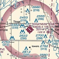
| Sectional chart |
|---|
|
| Airport distance calculator |
|---|
|
|
| Sunrise and sunset |
|---|
|
Times for 04-May-2026
| | Local
(UTC-5) | | Zulu
(UTC) |
|---|
| Morning civil twilight | | 05:53 | | 10:53 |
| Sunrise | | 06:28 | | 11:28 |
| Sunset | | 21:08 | | 02:08 |
| Evening civil twilight | | 21:44 | | 02:44 |
|
| Current date and time |
|---|
| Zulu (UTC) | 04-May-2026 09:05:52 |
|---|
| Local (UTC-5) | 04-May-2026 04:05:52 |
|---|
|
| METAR |
|---|
| KD60 | 040855Z AUTO 33015G22KT 10SM CLR 05/M02 A2970 RMK AO2
|
|
| TAF |
|---|
KXWA
35nm W | 040528Z 0406/0506 35022G32KT P6SM OVC150 FM040900 33017G27KT P6SM BKN140 FM041500 33023G35KT P6SM BKN035 FM050200 34017G26KT P6SM BKN090 FM050500 33011KT P6SM SCT100
|
|
| NOTAMs |
|---|
NOTAMs are issued by the DoD/FAA and will open in a separate window not controlled by AirNav.
|
|

