FAA INFORMATION EFFECTIVE 14 MAY 2026
Location
| FAA Identifier: | E01 |
| Lat/Long: | 31-34-56.9000N 102-54-32.5000W
31-34.948333N 102-54.541667W
31.5824722,-102.9090278
(estimated) |
| Elevation: | 2614.5 ft. / 796.9 m (surveyed) |
| Variation: | 09E (1995) |
| From city: | 1 mile SW of MONAHANS, TX |
| Time zone: | UTC -5 (UTC -6 during Standard Time) |
| Zip code: | 79756 |
Airport Operations
| Airport use: | Open to the public |
| Activation date: | 05/1946 |
| Control tower: | no |
| ARTCC: | FORT WORTH CENTER |
| FSS: | SAN ANGELO FLIGHT SERVICE STATION |
| NOTAMs facility: | SJT (NOTAM-D service available) |
| Attendance: | 0700-1700 |
| Wind indicator: | lighted |
| Segmented circle: | yes |
| Lights: | ACTVT PAPI RWY 12; MIRL RWY 01/19 & 12/30 - CTAF. |
| Beacon: | white-green (lighted land airport)
Operates sunset to sunrise. |
Airport Communications
| CTAF/UNICOM: | 122.8 |
| WX AWOS-3PT: | 118.225 (432-943-2457) |
| WX ASOS at INK (19 nm NW): | 118.325 (432-527-3320) |
- APCH/DEP SVC PRVDD BY FORT WORTH ARTCC (ZFW) ON FREQS 133.1/298.95 (MIDLAND RCAG).
Nearby radio navigation aids
| VOR radial/distance | | VOR name | | Freq | | Var |
|---|
| INKr125/24.5 | | WINK VORTAC | | 112.10 | | 11E |
| PEQr068/34.7 | | PECOS VOR/DME | | 116.50 | | 11E |
| FSTr354/38.0 | | FORT STOCKTON VORTAC | | 116.90 | | 11E |
Airport Services
| Fuel available: | 100LL JET-A |
| Parking: | tiedowns |
| Airframe service: | MINOR |
| Powerplant service: | MINOR |
| Bottled oxygen: | NONE |
| Bulk oxygen: | NONE |
Runway Information
Runway 12/30
| Dimensions: | 4268 x 75 ft. / 1301 x 23 m |
| Surface: | asphalt, in good condition |
| Weight bearing capacity: | |
| Runway edge lights: | medium intensity |
| RUNWAY 12 | | RUNWAY 30 |
| Latitude: | 31-35.160488N | | 31-34.738812N |
| Longitude: | 102-54.848862W | | 102-54.190490W |
| Elevation: | 2606.2 ft. | | 2610.4 ft. |
| Traffic pattern: | left | | left |
| Runway heading: | 118 magnetic, 127 true | | 298 magnetic, 307 true |
| Markings: | nonprecision, in good condition | | nonprecision, in good condition |
| Visual slope indicator: | 2-light PAPI on left (3.00 degrees glide path) | | |
| Touchdown point: | yes, no lights | | yes, no lights |
| Obstructions: | 25 ft. pole, marked, 495 ft. from runway, 22 ft. left of centerline, 11:1 slope to clear | | 46 ft. tree, 1035 ft. from runway, 36 ft. right of centerline, 18:1 slope to clear |
Runway 1/19
| Dimensions: | 2922 x 75 ft. / 891 x 23 m |
| Surface: | asphalt, in poor condition
NMRS LRG CRACKS. |
| Weight bearing capacity: | |
| Runway edge lights: | medium intensity |
| RUNWAY 1 | | RUNWAY 19 |
| Latitude: | 31-34.720540N | | 31-35.174378N |
| Longitude: | 102-54.669725W | | 102-54.480235W |
| Elevation: | 2614.5 ft. | | 2608.1 ft. |
| Traffic pattern: | left | | left |
| Runway heading: | 011 magnetic, 020 true | | 191 magnetic, 200 true |
| Markings: | basic, in good condition | | basic, in good condition |
| Touchdown point: | yes, no lights | | yes, no lights |
| Obstructions: | 25 ft. tank, 1190 ft. from runway, 60 ft. left of centerline, 39:1 slope to clear | | 38 ft. tree, 595 ft. from runway, 200 ft. right of centerline, 10:1 slope to clear |
Airport Ownership and Management from official FAA records
| Ownership: | Publicly-owned |
| Owner: | CITY OF MONAHANS
112 WEST 2ND ST
MONAHANS, TX 79756
Phone 432-940-2633 |
| Manager: | JOHN CUTBIRTH
P.O.BOX 1610
MONAHANS, TX 79756
Phone 432-940-2633 |
Additional Remarks
| A51-12 | APCH SLOPE 23:1 TO DSPLCD THR OVR 60 FT MKD/LTG PLINE, 1425 FT DSTC, 135 FT R. |
| - | DOWN SLOPE OFF END OF RWY 30. |
| - | WILDLIFE & BIRDS ON & INVOF ARPT. |
| - | FOR CD CTC FORT WORTH ARTCC AT 817-858-7584. |
| - | RWY 19 APCH, 325 FT AGL 2953 MSL ANT, 1.45 NM NE OF ARPT. |
| - | NMRS RWY LGTS OUT. |
| - | HOLD LINE SIGNS FADED WHITE, RWY NRS NOT VSB. |
Instrument Procedures
NOTE: All procedures below are presented as PDF files. If you need a reader for these files, you should download the free Adobe Reader.NOT FOR NAVIGATION. Please procure official charts for flight.
FAA instrument procedures published for use from 14 May 2026 at 0901Z to 11 June 2026 at 0900Z.
IAPs - Instrument Approach Procedures |
|---|
| RNAV (GPS) RWY 12 | |
download (197KB) |
| RNAV (GPS) RWY 30 | |
download (215KB) |
| NOTE: Special Alternate Minimums apply **CHANGED** | |
download (139KB) |
| NOTE: Special Take-Off Minimums/Departure Procedures apply | |
download (294KB) |
Other nearby airports with instrument procedures:
KINK - Winkler County Airport (19 nm NW)
KPEQ - Pecos Municipal Airport (33 nm W)
KODO - Odessa Airport-Schlemeyer Field (34 nm NE)
KFST - Fort Stockton-Pecos County Airport (40 nm S)
KMAF - Midland International Air and Space Port Airport (42 nm NE)
|
|

Road maps at:
MapQuest
Bing
Google
| Aerial photo |
|---|
WARNING: Photo may not be current or correct
 Photo by Marc Marchesseault
Taken in October 2006
Photo by Marc Marchesseault
Taken in October 2006
Do you have a better or more recent aerial photo of Roy Hurd Memorial Airport that you would like to share? If so, please send us your photo.
|
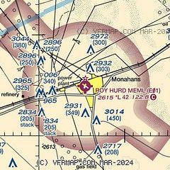
| Sectional chart |
|---|
|
| Airport distance calculator |
|---|
|
|
| Sunrise and sunset |
|---|
|
Times for 03-Jun-2026
| | Local
(UTC-5) | | Zulu
(UTC) |
|---|
| Morning civil twilight | | 06:20 | | 11:20 |
| Sunrise | | 06:48 | | 11:48 |
| Sunset | | 20:52 | | 01:52 |
| Evening civil twilight | | 21:19 | | 02:19 |
|
| Current date and time |
|---|
| Zulu (UTC) | 03-Jun-2026 10:50:29 |
|---|
| Local (UTC-5) | 03-Jun-2026 05:50:29 |
|---|
|
| METAR |
|---|
KINK
19nm NW | 030253Z AUTO 14009KT CLR 30/16 A3005 RMK AO2 SLP131 T03000156 53024 TSNO $
|
KODO
33nm NE | 031018Z AUTO 04011KT 10SM VCTS SCT050 SCT065 OVC100 18/16 A3017 RMK AO2 LTG DSNT E AND SW AND W RAE01 P0001 T01780156
|
KPEQ
33nm W | 031035Z AUTO 07007KT 10SM SCT019 BKN050 OVC070 19/16 A3014 RMK AO2 LTG DSNT E AND SE T01930157 PWINO
|
|
| TAF |
|---|
KINK
19nm NW | 030522Z 0306/0406 30010KT P6SM SCT080 BKN250 FM030700 05010KT P6SM -SHRA SCT080 BKN250 PROB30 0307/0310 VRB20G35KT -TSRA BKN050CB FM031300 12009KT P6SM OVC200
|
|
| NOTAMs |
|---|
NOTAMs are issued by the DoD/FAA and will open in a separate window not controlled by AirNav.
|
|


