FAA INFORMATION EFFECTIVE 14 MAY 2026
Location
| FAA Identifier: | INK |
| Lat/Long: | 31-46-47.3000N 103-12-06.1000W
31-46.788333N 103-12.101667W
31.7798056,-103.2016944
(estimated) |
| Elevation: | 2821.6 ft. / 860.0 m (surveyed) |
| Variation: | 08E (2010) |
| From city: | 3 miles NW of WINK, TX |
| Time zone: | UTC -5 (UTC -6 during Standard Time) |
| Zip code: | 79745 |
Airport Operations
| Airport use: | Open to the public |
| Activation date: | 08/1941 |
| Control tower: | no |
| ARTCC: | FORT WORTH CENTER |
| FSS: | SAN ANGELO FLIGHT SERVICE STATION |
| NOTAMs facility: | INK (NOTAM-D service available) |
| Attendance: | MON-SAT 0800-1800 |
| Wind indicator: | lighted |
| Segmented circle: | yes |
| Lights: | MIRL RWYS 04/22 & 13/31 PRESET LOW INTST; TO INCR INTST - CTAF. |
| Beacon: | white-green (lighted land airport)
Operates sunset to sunrise. |
Airport Communications
| CTAF/UNICOM: | 123.0 |
| WX ASOS: | 118.325 (432-527-3320) |
| WX AWOS-3PT at E01 (19 nm SE): | 118.225 (432-943-2457) |
- APCH/DEP SVC PRVDD BY FORT WORTH ARTCC (ZFW) ON FREQS 133.1/298.95 (MIDLAND RCAG).
Nearby radio navigation aids
| VOR radial/distance | | VOR name | | Freq | | Var |
|---|
| INKr148/6.1 | | WINK VORTAC | | 112.10 | | 11E |
| PEQr035/26.7 | | PECOS VOR/DME | | 116.50 | | 11E |
Airport Services
| Fuel available: | 100LL JET-A+
100LL:FUEL AVBL 24 HRS SELF SERVE OR FULL SVC. |
| Parking: | hangars and tiedowns |
| Airframe service: | NONE |
| Powerplant service: | NONE |
| Bottled oxygen: | NONE |
| Bulk oxygen: | NONE |
Runway Information
Runway 13/31
| Dimensions: | 5003 x 100 ft. / 1525 x 30 m |
| Surface: | asphalt, in good condition |
| Weight bearing capacity: | | Single wheel: | 26.0 | | Double wheel: | 40.0 |
|
| Runway edge lights: | medium intensity |
| RUNWAY 13 | | RUNWAY 31 |
| Latitude: | 31-46.981652N | | 31-46.345348N |
| Longitude: | 103-12.465232W | | 103-11.850340W |
| Elevation: | 2821.6 ft. | | 2811.8 ft. |
| Traffic pattern: | left | | left |
| Runway heading: | 132 magnetic, 140 true | | 312 magnetic, 320 true |
| Markings: | nonprecision, in good condition | | nonprecision, in good condition |
| Visual slope indicator: | 2-light PAPI on left (3.00 degrees glide path) | | 2-light PAPI on left (3.00 degrees glide path) |
| Touchdown point: | yes, no lights | | yes, no lights |
| Obstructions: | 5 ft. brush, 200 ft. from runway, 244 ft. right of centerline | | 8 ft. brush, 200 ft. from runway, 285 ft. left of centerline |
Runway 4/22
| Dimensions: | 3514 x 100 ft. / 1071 x 30 m |
| Surface: | asphalt, in good condition |
| Weight bearing capacity: | | Single wheel: | 26.0 | | Double wheel: | 40.0 |
|
| Runway edge lights: | medium intensity |
| RUNWAY 4 | | RUNWAY 22 |
| Latitude: | 31-46.780743N | | 31-47.149653N |
| Longitude: | 103-12.283567W | | 103-11.760378W |
| Elevation: | 2817.6 ft. | | 2810.5 ft. |
| Traffic pattern: | left | | left |
| Runway heading: | 042 magnetic, 050 true | | 222 magnetic, 230 true |
| Markings: | basic, in good condition | | basic, in good condition |
| Touchdown point: | yes, no lights | | yes, no lights |
| Obstructions: | 8 ft. brush, 200 ft. from runway, 39 ft. right of centerline | | 23 ft. pline, marked, 900 ft. from runway, 130 ft. left of centerline, 30:1 slope to clear |
Airport Ownership and Management from official FAA records
| Ownership: | Publicly-owned |
| Owner: | WINKLER COUNTY
WINKLER COUNTY COURTHOUSE, P.O. DRAWER Y
KERMIT, TX 79745
Phone 432-586-6658 |
| Manager: | CHARLES WOLF
100 E. WINKLER ST.
KERMIT, TX 79745
Phone 432-586-6658 |
Additional Remarks
| - | FOR CD IF UNA TO CTC ON FSS FREQ, CTC FORT WORTH ARTCC AT 817-858-7584. |
Instrument Procedures
NOTE: All procedures below are presented as PDF files. If you need a reader for these files, you should download the free Adobe Reader.NOT FOR NAVIGATION. Please procure official charts for flight.
FAA instrument procedures published for use from 14 May 2026 at 0901Z to 11 June 2026 at 0900Z.
IAPs - Instrument Approach Procedures |
|---|
| RNAV (GPS) RWY 13 | |
download (241KB) |
| RNAV (GPS) RWY 31 | |
download (181KB) |
| NOTE: Special Alternate Minimums apply **CHANGED** | |
download (139KB) |
| NOTE: Special Take-Off Minimums/Departure Procedures apply | |
download (107KB) |
Other nearby airports with instrument procedures:
E01 - Roy Hurd Memorial Airport (19 nm SE)
KPEQ - Pecos Municipal Airport (29 nm SW)
KODO - Odessa Airport-Schlemeyer Field (42 nm E)
E11 - Andrews County Airport (48 nm NE)
KMAF - Midland International Air and Space Port Airport (52 nm E)
|
|

Road maps at:
MapQuest
Bing
Google
| Aerial photo |
|---|
WARNING: Photo may not be current or correct
 Photo courtesy of Bill Gunn, TxDOT Aviation Division
Photo taken 10-Nov-2005
Photo courtesy of Bill Gunn, TxDOT Aviation Division
Photo taken 10-Nov-2005
Do you have a better or more recent aerial photo of Winkler County Airport that you would like to share? If so, please send us your photo.
|
| Sectional chart |
|---|
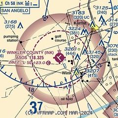
|
| Airport distance calculator |
|---|
|
|
| Sunrise and sunset |
|---|
|
Times for 01-Jun-2026
| | Local
(UTC-5) | | Zulu
(UTC) |
|---|
| Morning civil twilight | | 06:21 | | 11:21 |
| Sunrise | | 06:49 | | 11:49 |
| Sunset | | 20:52 | | 01:52 |
| Evening civil twilight | | 21:20 | | 02:20 |
|
| Current date and time |
|---|
| Zulu (UTC) | 02-Jun-2026 01:58:57 |
|---|
| Local (UTC-5) | 01-Jun-2026 20:58:57 |
|---|
|
| METAR |
|---|
| KINK | 012253Z AUTO 13015G20KT CLR 36/14 A2991 RMK AO2 SLP082 T03560139 TSNO $
|
|
| TAF |
|---|
| KINK | 011720Z 0118/0218 14014G20KT P6SM SCT070 SCT250 FM020200 13010KT P6SM FEW200 FM021600 13014KT P6SM SCT045 SCT250
|
|
| NOTAMs |
|---|
NOTAMs are issued by the DoD/FAA and will open in a separate window not controlled by AirNav.
|
|


