FAA INFORMATION EFFECTIVE 15 MAY 2025
Location
| FAA Identifier: | E63 |
| Lat/Long: | 32-57-36.6100N 112-40-25.0950W
32-57.610167N 112-40.418250W
32.9601694,-112.6736375
(estimated) |
| Elevation: | 788.7 ft. / 240 m (estimated) |
| Variation: | 13E (1985) |
| From city: | 2 miles E of GILA BEND, AZ |
| Time zone: | UTC -7 (year round; does not observe DST) |
| Zip code: | 85337 |
Airport Operations
| Airport use: | Open to the public |
| Activation date: | 01/1966 |
| Control tower: | no |
| ARTCC: | ALBUQUERQUE CENTER |
| FSS: | PRESCOTT FLIGHT SERVICE STATION |
| NOTAMs facility: | PRC (NOTAM-D service available) |
| Attendance: | UNATNDD |
| Pattern altitude: | 1588.7 ft. MSL |
| Wind indicator: | lighted, AIRPORT LIGHTED WINDSOCK OUT OF SERVICE INDEF. |
| Segmented circle: | yes |
| Lights: | ACTVT MIRL RWY 04/22. CTAF LIGHTING OTS INDEF. |
| Beacon: | white-green (lighted land airport)
AIRPORT BEACON OUT OF SERVICE INDEF. Operates sunset to sunrise. |
Airport Communications
- COMMUNICATIONS PRVDD BY PRESCOTT RADIO ON FREQ 122.1R/116.6T (GILA BEND RCO).
Nearby radio navigation aids
| VOR radial/distance | | VOR name | | Freq | | Var |
|---|
| GBN at field | | GILA BEND VORTAC | | 116.60 | | 14E |
| BXKr152/30.6 | | BUCKEYE VORTAC | | 110.60 | | 14E |
| TFDr265/38.8 | | STANFIELD VORTAC | | 114.80 | | 12E |
Airport Services
| Fuel available: | 100LL
100LL:SELF SVC H24 WITH CREDIT CARD. |
| Parking: | tiedowns |
Runway Information
Runway 4/22
| Dimensions: | 5200 x 75 ft. / 1585 x 23 m |
| Surface: | asphalt, in good condition |
| Weight bearing capacity: | |
| Runway edge lights: | medium intensity
RWY 04/22 AND TWY LIGHTING SYSTEM OUT OF SERVCE INDEF. |
| Operational restrictions: | PRIMARY SFC +5-20 FT BRUSH & TREES 100-125 FT S OF CNTRLN. AREA PARL RWY NARROWS TO 30 FT AT CULVERT. |
| RUNWAY 4 | | RUNWAY 22 |
| Latitude: | 32-57.379833N | | 32-57.840500N |
| Longitude: | 112-40.847333W | | 112-39.989167W |
| Elevation: | 774.2 ft. | | 788.7 ft. |
| Traffic pattern: | left | | left |
| Markings: | nonprecision, in good condition | | nonprecision, in good condition |
| Visual slope indicator: | 2-light PAPI on left (3.00 degrees glide path) | | 2-light PAPI on left (3.00 degrees glide path) |
| Runway end identifier lights: | no | | no |
| Touchdown point: | yes, no lights | | yes, no lights |
| Obstructions: | 17 ft. tree, 266 ft. from runway, 30 ft. right of centerline, 3:1 slope to clear
RWY 04, 3-20 FT BRUSH AND TREES 0-200 FT FM THR, 105-125 FT RIGHT OF CNTRLN. 2-4 FT BERM 115 FT RIGHT OF CNTRLN, ENTIRE LENGHT OF RWY. | | 16 ft. tree, 202 ft. from runway, 50 ft. left of centerline
RWY 22, 3-15 FT BRUSH, 0- 200 FT FM THR, 60-125 FT LEFT OF CNTRLN. 2-4 FT BRUSH, 0-200 FT FM THR, 20-125 FT RIGHT OF CNTRLN. 4 FT DITCH, 0-200 FT FM THR, 80 FT BOTH SIDES OF CNTRLN. |
Airport Ownership and Management from official FAA records
| Ownership: | Publicly-owned |
| Owner: | TOWN OF GILA BEND
PO BOX A
GILA BEND, AZ 85337
Phone 623-810-4662 |
| Manager: | COREY DRURY
TOWN OF GILA BEND, DEPT. OF PUB WKS P.O. BOX A
GILA BEND, AZ 85337
Phone 623-810-4662 |
Additional Remarks
| - | FOR CD CTC LUKE APCH AT 623-856-7361. IF UNA CTC ALBUQUERQUE ARTCC AT 505-856-4861. |
| - | AREA ALONGSIDE RWY NARROWS TO 30 FT AT CULVERT. |
Instrument Procedures
There are no published instrument procedures at E63.
Some nearby airports with instrument procedures:
KGYR - Phoenix Goodyear Airport (32 nm NE)
KLUF - Luke Air Force Base (37 nm NE)
KGEU - Glendale Regional Airport (39 nm NE)
P19 - Stellar Airpark (43 nm NE)
KPHX - Phoenix Sky Harbor International Airport (44 nm NE)
|
|

Road maps at:
MapQuest
Bing
Google
| Aerial photo |
|---|
WARNING: Photo may not be current or correct
 Photo by Diane Larson
Photo taken 15-Jun-2019
looking northeast.
Photo by Diane Larson
Photo taken 15-Jun-2019
looking northeast.
Do you have a better or more recent aerial photo of Gila Bend Municipal Airport that you would like to share? If so, please send us your photo.
|
| Sectional chart |
|---|
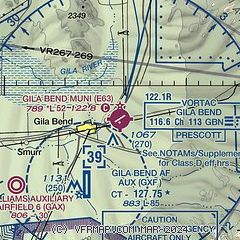
|
| Airport distance calculator |
|---|
|
|
| Sunrise and sunset |
|---|
|
Times for 29-May-2025
| | Local
(UTC-7) | | Zulu
(UTC) |
|---|
| Morning civil twilight | | 04:57 | | 11:57 |
| Sunrise | | 05:25 | | 12:25 |
| Sunset | | 19:31 | | 02:31 |
| Evening civil twilight | | 19:59 | | 02:59 |
|
| Current date and time |
|---|
| Zulu (UTC) | 30-May-2025 06:45:59 |
|---|
| Local (UTC-7) | 29-May-2025 23:45:59 |
|---|
|
| METAR |
|---|
KGXF
5nm SW | 300555Z 15006KT 10SM FEW190 25/M02 A2992 RMK AO2A SLP118 T02491018 10343 20249 52010 FZRANO $
|
|
| TAF |
|---|
KLUF
37nm NE | 300605Z 3006/3110 VRB06KT 9999 SCT160 BKN200 QNH2988INS BECMG 3018/3019 23010G15KT 9999 SCT200 BKN250 QNH2993INS BECMG 3103/3104 VRB06KT 9999 SCT180 QNH2982INS TX39/3023Z TN24/3013Z LAST NO AMDS AFT 3006 NEXT 3012
|
|
| NOTAMs |
|---|
NOTAMs are issued by the DoD/FAA and will open in a separate window not controlled by AirNav.
|
|


