FAA INFORMATION EFFECTIVE 15 MAY 2025
Location
| FAA Identifier: | EBA |
| Lat/Long: | 34-05-43.4490N 082-49-02.9730W
34-05.724150N 082-49.049550W
34.0954025,-82.8174925
(estimated) |
| Elevation: | 614.5 ft. / 187.3 m (surveyed) |
| Variation: | 06W (2015) |
| From city: | 2 miles E of ELBERTON, GA |
| Time zone: | UTC -4 (UTC -5 during Standard Time) |
| Zip code: | 30635 |
Airport Operations
| Airport use: | Open to the public |
| Control tower: | no |
| ARTCC: | ATLANTA CENTER |
| FSS: | MACON FLIGHT SERVICE STATION |
| NOTAMs facility: | MCN (NOTAM-D service available) |
| Attendance: | MON-SAT 0800-1800, ALL SUN 1300-1800 |
| Wind indicator: | lighted |
| Segmented circle: | yes |
| Lights: | ACTVT PAPI RWY 11 & 29; MIRL RWY 11/29 - CTAF. MIRL RWY 11/29 UNAVBL DURG DALGT HRS, ON PHOTOCELL. |
| Beacon: | white-green (lighted land airport)
Operates sunset to sunrise. |
Airport Communications
| CTAF/UNICOM: | 122.8 |
| WX AWOS-3: | 118.15 (706-283-8133) |
| WX AWOS-3 at IIY (19 nm S): | 118.375 (706-678-3647) |
- APCH/DEP SVC PRVDD BY ATLANTA ARTCC ON FREQS 127.5/316.05 (ATHENS RCAG).
Nearby radio navigation aids
| VOR radial/distance | | VOR name | | Freq | | Var |
|---|
| ELWr185/19.5 | | ELECTRIC CITY VORTAC | | 108.60 | | 00E |
| AHNr071/26.7 | | ATHENS VOR/DME | | 116.95 | | 00E |
| NDB name | | Hdg/Dist | | Freq | | Var | | ID |
|---|
| BARROW COUNTY | | 081/39.6 | | 404 | | 05W | | BMW | -... -- .-- |
Airport Services
| Fuel available: | 100LL |
| Parking: | tiedowns |
| Airframe service: | NONE |
| Powerplant service: | NONE |
| Bottled oxygen: | NONE |
| Bulk oxygen: | NONE |
Runway Information
Runway 11/29
| Dimensions: | 5004 x 75 ft. / 1525 x 23 m |
| Surface: | asphalt, in fair condition |
| Weight bearing capacity: | |
| Runway edge lights: | medium intensity |
| RUNWAY 11 | | RUNWAY 29 |
| Latitude: | 34-05.786772N | | 34-05.661507N |
| Longitude: | 082-49.539670W | | 082-48.559447W |
| Elevation: | 614.5 ft. | | 602.5 ft. |
| Traffic pattern: | left | | left |
| Runway heading: | 105 magnetic, 099 true | | 285 magnetic, 279 true |
| Markings: | nonprecision, in fair condition | | nonprecision, in fair condition |
| Visual slope indicator: | 2-light PAPI on left (3.75 degrees glide path)
RWY 11 PAPI UNUSBL 6 DEGS RIGHT OF RCL. | | 2-light PAPI on left (3.75 degrees glide path)
RWY 29 PAPI UNUSBL 8 DEGS LEFT OF RCL. |
| Touchdown point: | yes, no lights | | yes, no lights |
| Obstructions: | 44 ft. trees, 889 ft. from runway, 335 ft. right of centerline, 15:1 slope to clear | | 46 ft. trees, 460 ft. from runway, 260 ft. left of centerline, 5:1 slope to clear |
Airport Ownership and Management from official FAA records
| Ownership: | Publicly-owned |
| Owner: | ELBERT COUNTY
COUNTY COURTHOUSE, 45 FORREST AVENUE
ELBERTON, GA 30635
Phone 706-283-2000 |
| Manager: | RANDY HARALSON, FBO
1136 VON TRINA RD
ELBERTON, GA 30635
Phone 706-283-2035 |
Additional Remarks
| - | DEER ON & INVOF ARPT. |
| - | ROAD LCTD 200 FT SOUTH OF RCL. |
| - | RISING TRRN 10 FT HI LCTD NORTH OF RWY 11/29 STARTING FM RCL. |
| - | RWY 29 APCH: TREES 36 FT TALL, LCTD 452 FT FROM RWY END, 280 FT SOUTH OF RCL. TREES 57 FT TALL, LCTD 770 FT FROM RWY END, 295 FT SOUTH OF RCL. TREES 66 FT TALL, LCTD 992 FT FM RWY END, 30 FT SOUTH OF RCL. |
| - | FOR CD CTC ATLANTA ARTCC AT 770-210-7692. |
Instrument Procedures
NOTE: All procedures below are presented as PDF files. If you need a reader for these files, you should download the free Adobe Reader.NOT FOR NAVIGATION. Please procure official charts for flight.
FAA instrument procedures published for use from 15 May 2025 at 0901Z to 13 June 2025 at 0900z.
IAPs - Instrument Approach Procedures |
|---|
| RNAV (GPS) RWY 11 | |
download (219KB) |
| RNAV (GPS) RWY 29 | |
download (270KB) |
| VOR RWY 11 | |
download (195KB) |
| NOTE: Special Alternate Minimums apply | |
download (158KB) |
| NOTE: Special Take-Off Minimums/Departure Procedures apply | |
download (522KB) |
Other nearby airports with instrument procedures:
KIIY - Washington/Wilkes County Airport (19 nm S)
18A - Franklin-Hart Airport (21 nm NW)
KAND - Anderson Regional Airport (25 nm N)
KAHN - Athens/Ben Epps Airport (27 nm W)
KCPP - Greene County Regional Airport (34 nm SW)
|
|

Road maps at:
MapQuest
Bing
Google
| Aerial photo |
|---|
WARNING: Photo may not be current or correct

Do you have a better or more recent aerial photo of Elbert County Airport-Patz Field that you would like to share? If so, please send us your photo.
|
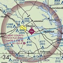
| Sectional chart |
|---|
|
| Airport distance calculator |
|---|
|
|
| Sunrise and sunset |
|---|
|
Times for 31-May-2025
| | Local
(UTC-4) | | Zulu
(UTC) |
|---|
| Morning civil twilight | | 05:53 | | 09:53 |
| Sunrise | | 06:22 | | 10:22 |
| Sunset | | 20:36 | | 00:36 |
| Evening civil twilight | | 21:04 | | 01:04 |
|
| Current date and time |
|---|
| Zulu (UTC) | 31-May-2025 08:51:52 |
|---|
| Local (UTC-4) | 31-May-2025 04:51:52 |
|---|
|
| METAR |
|---|
| KEBA | 310835Z AUTO 27005KT 10SM CLR 15/11 A2984 RMK AO2 T01500110
|
KIIY
19nm S | 310835Z AUTO 31005KT 10SM CLR 14/11 A2985 RMK AO2 T01440111
|
|
| TAF |
|---|
KAND
25nm N | 310530Z 3106/0106 VRB03KT P6SM SKC FM311200 24009KT P6SM SKC FM311500 27014G23KT P6SM FEW050 FM010000 26007KT P6SM SKC
|
KAHN
27nm W | 310525Z 3106/0106 30006KT P6SM SKC FM311700 29012G22KT P6SM FEW050 FM010100 27004KT P6SM SKC
|
|
| NOTAMs |
|---|
NOTAMs are issued by the DoD/FAA and will open in a separate window not controlled by AirNav.
|
|


