FAA INFORMATION EFFECTIVE 20 MARCH 2025
Location
| FAA Identifier: | EKO |
| Lat/Long: | 40-49-29.9950N 115-47-28.8150W
40-49.499917N 115-47.480250W
40.8249986,-115.7913375
(estimated) |
| Elevation: | 5139.8 ft. / 1566.6 m (surveyed) |
| Variation: | 12E (2020) |
| From city: | 1 mile W of ELKO, NV |
| Time zone: | UTC -7 (UTC -8 during Standard Time) |
| Zip code: | 89801 |
Airport Operations
| Airport use: | Open to the public |
| Activation date: | 04/1940 |
| Control tower: | no |
| ARTCC: | SALT LAKE CITY CENTER |
| FSS: | RENO FLIGHT SERVICE STATION |
| NOTAMs facility: | EKO (NOTAM-D service available) |
| Attendance: | 0500-2100 |
| Wind indicator: | lighted |
| Segmented circle: | yes |
| Lights: | ACTVT MALSR RWY 24; MIRL RWY 06/24 - CTAF. PAPI RWY 06 & 24 ON CONSLY. |
| Beacon: | white-green (lighted land airport)
Operates sunset to sunrise. |
| Fire and rescue: | ARFF index A |
Airport Communications
| CTAF/UNICOM: | 123.0 |
| WX ASOS: | 119.275 (775-778-9639) |
- APCH/DEP CTL SVC PRVDD BY SALT LAKE ARTCC (ZLC) ON FREQ 132.25/338.35 (BATTLE MOUNTAIN RCAG).
Nearby radio navigation aids
| VOR radial/distance | | VOR name | | Freq | | Var |
|---|
| BQUr324/4.1 | | BULLION VOR/DME | | 115.85 | | 17E |
Airport Services
| Fuel available: | 100LL JET-A
100LL:100LL, A AVAILABLE 24/7. |
| Parking: | hangars and tiedowns |
| Airframe service: | MAJOR |
| Powerplant service: | MAJOR |
| Bottled oxygen: | NONE |
| Bulk oxygen: | HIGH/LOW |
Runway Information
Runway 6/24
| Dimensions: | 7454 x 150 ft. / 2272 x 46 m |
| Surface: | asphalt/grooved, in good condition |
| Weight bearing capacity: | | PCN 63 /F/B/X/T | | Single wheel: | 78.0 | | Double wheel: | 105.0 | | Double tandem: | 170.0 |
|
| Runway edge lights: | medium intensity |
| RUNWAY 6 | | RUNWAY 24 |
| Latitude: | 40-49.144782N | | 40-49.592002N |
| Longitude: | 115-48.337363W | | 115-46.832962W |
| Elevation: | 5051.1 ft. | | 5071.1 ft. |
| Traffic pattern: | right | | left |
| Runway heading: | 057 magnetic, 069 true | | 237 magnetic, 249 true |
| Displaced threshold: | no | | 1036 ft. |
| Declared distances: | TORA:7217 TODA:7217 ASDA:7217 LDA:7217 | | TORA:7454 TODA:7454 ASDA:7454 LDA:6418 |
| Markings: | precision, in good condition | | precision, in good condition |
| Visual slope indicator: | 4-light PAPI on left (3.00 degrees glide path) | | 4-light PAPI on left (3.25 degrees glide path)
PAPI RWY 24 DOES NOT PRVD OBSTN CLNC BYD 6.5 NM FM THR. |
| Approach lights: | | | MALSR: 1,400 foot medium intensity approach lighting system with runway alignment indicator lights |
| Runway end identifier lights: | no | | no |
| Touchdown point: | yes, no lights | | yes, no lights |
| Instrument approach: | | | LDA/DME |
| Obstructions: | 24 ft. road, 700 ft. from runway, 325 ft. right of centerline, 20:1 slope to clear | | 99 ft. pole, 2300 ft. from runway, 450 ft. right of centerline, 21:1 slope to clear |
Runway 12/30
| Dimensions: | 3015 x 60 ft. / 919 x 18 m |
| Surface: | asphalt, in good condition |
| Weight bearing capacity: | | PCN 4 /F/B/Y/T | | Single wheel: | 12.0 |
|
| RUNWAY 12 | | RUNWAY 30 |
| Latitude: | 40-49.998105N | | 40-49.651920N |
| Longitude: | 115-47.454812W | | 115-46.986630W |
| Elevation: | 5139.8 ft. | | 5080.0 ft. |
| Traffic pattern: | right | | left |
| Runway heading: | 122 magnetic, 134 true | | 302 magnetic, 314 true |
| Displaced threshold: | 906 ft. | | 143 ft. |
| Declared distances: | TORA:3015 TODA:3015 ASDA:3015 LDA:2109 | | TORA:3015 TODA:3015 ASDA:3015 LDA:2872 |
| Markings: | basic, in good condition | | basic, in good condition |
| Runway end identifier lights: | no | | no |
| Touchdown point: | yes, no lights | | yes, no lights |
| Obstructions: | 26 ft. pole, marked, 650 ft. from runway, 75 ft. left of centerline, 17:1 slope to clear | | 30 ft. pole, 900 ft. from runway, 100 ft. left of centerline, 23:1 slope to clear |
Airport Ownership and Management from official FAA records
| Ownership: | Publicly-owned |
| Owner: | CITY OF ELKO
975 TERMINAL WAY
ELKO, NV 89801
Phone 775-777-7190 |
| Manager: | JAMES FOSTER
975 TERMINAL WAY
ELKO, NV 89801
Phone 775-777-7194 |
Additional Remarks
| - | RWY 24 DESIGNATED CALM WIND RWY. |
| - | SFC CONDS NOT MNT DLY 2100-0600. |
| - | FOR CD IF UNA TO CTC ON FSS FREQ, CTC SALT LAKE ARTCC AT 801-320-2568. |
| - | RWY 30/12 NOT AVBL FOR SCHEDULED ACR OPNS WITH MORE THAN 9 PSGR SEATS OR UNSCHEDULED ACR OPNS WITH AT LEAST 31 PSGR SEATS. |
| - | PPR FOR ALL ACFT OPNS OVER 100000 LBS CALL 775-777-7190. |
| - | TKOF ONLY ON RWY 12. LAND ONLY ON RWY 30. |
| - | NO TGL RWY 12/30. |
| - | STEEP SLOPE/GRADIENT RWY 30 UPWARD. |
Instrument Procedures
NOTE: All procedures below are presented as PDF files. If you need a reader for these files, you should download the free Adobe Reader.NOT FOR NAVIGATION. Please procure official charts for flight.
FAA instrument procedures published for use from 20 March 2025 at 0901Z to 17 April 2025 at 0900z.
IAPs - Instrument Approach Procedures |
|---|
| RNAV (GPS) RWY 06 | |
download (269KB) |
| RNAV (GPS) RWY 24 | |
download (336KB) |
| LDA/DME RWY 24 | |
download (336KB) |
| NOTE: Special Alternate Minimums apply **CHANGED** | |
download (143KB) |
| NOTE: Special Take-Off Minimums/Departure Procedures apply | |
download (161KB) |
Other nearby airports with instrument procedures:
KBAM - Battle Mountain Airport (51 nm W)
10U - Owyhee Airport (70 nm N)
05U - Eureka Airport (74 nm S)
KENV - Wendover Airport (80 nm E)
KWMC - Winnemucca Municipal Airport (92 nm W)
|
|

Road maps at:
MapQuest
Bing
Google
| Aerial photo |
|---|
WARNING: Photo may not be current or correct
 looking southwest.
Do you have a better or more recent aerial photo of Elko Regional Airport that you would like to share? If so, please send us your photo.
|
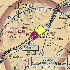
| Sectional chart |
|---|
|
CAUTION: Diagram may not be current
 Download PDF
of official airport diagram from the FAA
| Airport distance calculator |
|---|
|
|
| Sunrise and sunset |
|---|
|
Times for 16-Apr-2025
| | Local
(UTC-7) | | Zulu
(UTC) |
|---|
| Morning civil twilight | | 05:35 | | 12:35 |
| Sunrise | | 06:04 | | 13:04 |
| Sunset | | 19:22 | | 02:22 |
| Evening civil twilight | | 19:51 | | 02:51 |
|
| Current date and time |
|---|
| Zulu (UTC) | 16-Apr-2025 19:47:40 |
|---|
| Local (UTC-7) | 16-Apr-2025 12:47:40 |
|---|
|
| METAR |
|---|
| KEKO | 161856Z AUTO VRB06KT 10SM FEW090 SCT110 20/M02 A2987 RMK AO2 LTG DSNT S SLP080 T02001017
|
|
| TAF |
|---|
| KEKO | 161720Z 1618/1718 VRB06KT P6SM BKN100 FM162100 28007KT P6SM OVC100
|
|
| NOTAMs |
|---|
NOTAMs are issued by the DoD/FAA and will open in a separate window not controlled by AirNav.
|
|


