FAA INFORMATION EFFECTIVE 11 JUNE 2026
Location
| FAA Identifier: | F51 |
| Lat/Long: | 32-56-19.7740N 095-16-43.9230W
32-56.329567N 095-16.732050W
32.9388261,-95.2788675
(estimated) |
| Elevation: | 513.4 ft. / 156.5 m (surveyed) |
| Variation: | 08E (1965) |
| From city: | 2 miles SE of WINNSBORO, TX |
| Time zone: | UTC -5 (UTC -6 during Standard Time) |
| Zip code: | 75494 |
Airport Operations
| Airport use: | Open to the public |
| Activation date: | 05/1971 |
| Control tower: | no |
| ARTCC: | FORT WORTH CENTER |
| FSS: | FORT WORTH FLIGHT SERVICE STATION |
| NOTAMs facility: | FTW (NOTAM-D service available) |
| Attendance: | UNATNDD |
| Wind indicator: | lighted |
| Segmented circle: | yes |
| Lights: | ACTVT MIRL RWY 01/19 - CTAF. |
| Beacon: | white-green (lighted land airport)
Operates sunset to sunrise. |
Airport Communications
| CTAF: | 122.9 |
| LONGVIEW APPROACH: | 128.75 [OPR 1200-0200Z++ MON-FRI; 1800-2300Z++ SUN; CLSD SAT AND HOL, OT CTC FORT WORTH CENTER 133.5 350.35.] |
| LONGVIEW DEPARTURE: | 128.75 [OPR 1200-0200Z++ MON-FRI; 1800-2300Z++ SUN; CLSD SAT AND HOL, OT CTC FORT WORTH CENTER 133.5 350.35.] |
| WX AWOS-3PT at JDD (16 nm SW): | 118.9 (903-768-3065) |
| WX AWOS-3 at OSA (19 nm NE): | 119.775 (903-575-4027) |
- APCH/DEP SVC PRVDD BY FORT WORTH ARTCC (ZFW) ON FREQS 132.025/317.75 (CUMBY RCAG) WHEN LONGVIEW APCH CTL CLSD.
Nearby radio navigation aids
| VOR radial/distance | | VOR name | | Freq | | Var |
|---|
| TYRr004/35.5 | | TYLER VOR/DME | | 114.20 | | 06E |
| PRXr160/37.2 | | PARIS VOR/DME | | 113.60 | | 07E |
| NDB name | | Hdg/Dist | | Freq | | Var | | ID |
|---|
| AMBASSADOR | | 331/22.8 | | 404 | | 07E | | ABG | .- -... --. |
Airport Services
| Fuel available: | 100LL MOGAS
100LL:FUEL 24 HR SELF SERVE. MOGAS AVBL. |
| Parking: | tiedowns |
| Airframe service: | MINOR |
| Powerplant service: | MINOR |
| Bottled oxygen: | NONE |
| Bulk oxygen: | NONE |
Runway Information
Runway 1/19
| Dimensions: | 3215 x 50 ft. / 980 x 15 m |
| Surface: | asphalt, in good condition |
| Weight bearing capacity: | |
| Runway edge lights: | medium intensity |
| RUNWAY 1 | | RUNWAY 19 |
| Latitude: | 32-56.077460N | | 32-56.581687N |
| Longitude: | 095-16.829008W | | 095-16.635077W |
| Elevation: | 493.0 ft. | | 513.3 ft. |
| Traffic pattern: | right | | left |
| Runway heading: | 010 magnetic, 018 true | | 190 magnetic, 198 true |
| Markings: | nonprecision, in good condition | | nonprecision, in good condition |
| Touchdown point: | yes, no lights | | yes, no lights |
| Obstructions: | 30 ft. trees, 320 ft. from runway, 125 ft. right of centerline, 4:1 slope to clear
20 FT TREES 90 FT DSTC, 100 FT RIGHT. | | 60 ft. trees, 880 ft. from runway, 195 ft. left and right of centerline, 11:1 slope to clear
20 FT TREES, 87 FT DSTC, 120 FT L. |
Airport Ownership and Management from official FAA records
| Ownership: | Publicly-owned |
| Owner: | CITY OF WINNSBORO
501 SOUTH MAIN
WINNSBORO, TX 75494
Phone 903-342-3654 |
| Manager: | DARYL LAWRENCE
501 SOUTH MAIN
WINNSBORO, TX 75494
Phone 903-342-3654
EXT. 500 |
Additional Remarks
| - | FOR CD CTC FORT WORTH ARTCC AT 817-858-7584. |
Instrument Procedures
NOTE: All procedures below are presented as PDF files. If you need a reader for these files, you should download the free Adobe Reader.NOT FOR NAVIGATION. Please procure official charts for flight.
FAA instrument procedures published for use from 11 June 2026 at 0901Z to 09 July 2026 at 0900z.
IAPs - Instrument Approach Procedures |
|---|
| RNAV (GPS)-A | |
download (160KB) |
| NOTE: Special Take-Off Minimums/Departure Procedures apply | |
download (113KB) |
Other nearby airports with instrument procedures:
KJDD - Wood County Airport/Collins Field (16 nm SW)
F53 - Franklin County Airport (17 nm N)
KOSA - Mount Pleasant Regional Airport (19 nm NE)
KSLR - Sulphur Springs Municipal Airport (22 nm NW)
KJXI - Fox Stephens Field/Gilmer Municipal Airport (22 nm SE)
|
|

Road maps at:
MapQuest
Bing
Google
| Aerial photo |
|---|
WARNING: Photo may not be current or correct

Do you have a better or more recent aerial photo of Winnsboro Municipal Airport that you would like to share? If so, please send us your photo.
|
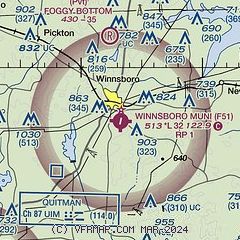
| Sectional chart |
|---|
|
CAUTION: Diagram may not be current

| Airport distance calculator |
|---|
|
|
| Sunrise and sunset |
|---|
|
Times for 19-Jun-2026
| | Local
(UTC-5) | | Zulu
(UTC) |
|---|
| Morning civil twilight | | 05:45 | | 10:45 |
| Sunrise | | 06:14 | | 11:14 |
| Sunset | | 20:31 | | 01:31 |
| Evening civil twilight | | 21:00 | | 02:00 |
|
| Current date and time |
|---|
| Zulu (UTC) | 19-Jun-2026 12:47:54 |
|---|
| Local (UTC-5) | 19-Jun-2026 07:47:54 |
|---|
|
| METAR |
|---|
KJDD
16nm SW | 191235Z AUTO 00000KT 8SM FEW012 26/25 A2990 RMK AO2 LTG DSNT E AND SE T02570250 $
|
KOSA
19nm NE | 191235Z AUTO 00000KT 5SM BR BKN008 OVC012 26/25 A2991 RMK AO2 T02590247
|
KSLR
22nm NW | 190823Z AUTO RMK AO2 PWINO TSNO
|
KJXI
22nm SE | 191235Z AUTO 00000KT 5SM BR SCT001 OVC015 26/24 A2991 RMK AO2 T02620240
|
|
| TAF |
|---|
KTYR
35nm S | 191142Z 1912/2012 16006KT P6SM OVC007 FM191400 18008KT P6SM BKN015 FM191600 18008KT P6SM VCTS BKN025CB TEMPO 1916/1920 VRB20G30KT 2SM TSRA BR BKN020CB FM192000 01008KT P6SM -TSRA SCT040 BKN070CB FM200000 09007KT P6SM SCT040 BKN070 FM200500 08004KT P6SM BKN015 FM200900 VRB04KT P6SM VCTS BKN015CB
|
|
| NOTAMs |
|---|
NOTAMs are issued by the DoD/FAA and will open in a separate window not controlled by AirNav.
|
|


