FAA INFORMATION EFFECTIVE 30 OCTOBER 2025
Location
| FAA Identifier: | SLR |
| Lat/Long: | 33-09-35.4000N 095-37-16.1000W
33-09.590000N 095-37.268333W
33.1598333,-95.6211389
(estimated) |
| Elevation: | 489.3 ft. / 149.1 m (surveyed) |
| Variation: | 03E (2010) |
| From city: | 2 miles NW of SULPHUR SPRINGS, TX |
| Time zone: | UTC -6 (UTC -5 during Daylight Saving Time) |
| Zip code: | 75482 |
Airport Operations
| Airport use: | Open to the public |
| Activation date: | 01/1940 |
| Control tower: | no |
| ARTCC: | FORT WORTH CENTER |
| FSS: | FORT WORTH FLIGHT SERVICE STATION |
| NOTAMs facility: | SLR (NOTAM-D service available) |
| Attendance: | SUN BY REQUEST, ALL MON-SAT 0800-1800
FOR ATTENDANT AFT HRS CALL POLICE DISPATCH 903-885-7602.
FOR ATTENDANT ON SUN CALL 903-885-4911 DURG ATTENDED HRS. |
| Wind indicator: | lighted |
| Segmented circle: | yes |
| Lights: | MIRL RWY 01/19 PRESET LOW DUSK-DAWN. TO INCR INTST AND ACTVT REIL RWYS 01 & 19 - CTAF. PAPI RWYS 01 & 19 OPR CONSLY. |
| Beacon: | white-green (lighted land airport)
Operates sunset to sunrise. |
Airport Communications
| CTAF/UNICOM: | 123.075 |
| WX AWOS-3: | 118.35 (903-885-9605) |
- APCH/DEP SVC PRVDD BY FORT WORTH ARTCC (ZFW) ON FREQS 132.025/317.75 (CUMBY RCAG).
Nearby radio navigation aids
| VOR radial/distance | | VOR name | | Freq | | Var |
|---|
| PRXr194/24.5 | | PARIS VOR/DME | | 113.60 | | 07E |
| BYPr120/38.2 | | BONHAM VORTAC | | 114.60 | | 06E |
Airport Services
| Fuel available: | 100LL JET-A
100LL:100LL AVBL 24 HRS SELF-SERVE. |
| Parking: | hangars and tiedowns |
| Airframe service: | MAJOR |
| Powerplant service: | MAJOR |
Runway Information
Runway 1/19
| Dimensions: | 5001 x 75 ft. / 1524 x 23 m |
| Surface: | concrete, in excellent condition |
| Weight bearing capacity: | | Single wheel: | 30.0 | | Double wheel: | 50.0 |
|
| Runway edge lights: | medium intensity |
| RUNWAY 1 | | RUNWAY 19 |
| Latitude: | 33-09.183417N | | 33-09.996283N |
| Longitude: | 095-37.351017W | | 095-37.186433W |
| Elevation: | 489.3 ft. | | 465.9 ft. |
| Traffic pattern: | left | | left |
| Runway heading: | 007 magnetic, 010 true | | 187 magnetic, 190 true |
| Markings: | precision, in good condition | | precision, in good condition |
| Visual slope indicator: | 4-light PAPI on left (3.00 degrees glide path) | | 4-light PAPI on left (3.00 degrees glide path)
PAPI UNUSBL BYD 8 DEGS RIGHT OF RCL. |
| Runway end identifier lights: | yes | | yes |
| Touchdown point: | yes, no lights | | yes, no lights |
| Obstructions: | 5 ft. fence, 201 ft. from runway, 249 ft. left of centerline, 1:1 slope to clear
5 FT FENCE 0-199 FT DSTC, 249 FT LEFT. | | none
10 FT BRUSH, 10 FT DSTC, 132 R. |
Airport Ownership and Management from official FAA records
| Ownership: | Publicly-owned |
| Owner: | CITY OF SULPHUR SPRINGS
125 SOUTH DAVIS ST.
SULPHUR SPRINGS, TX 75482
Phone 903-885-7541 |
| Manager: | JOEY BAKER
1220 CESSNA DR.
SULPHUR SPRINGS, TX 75482
Phone 903-885-4911 |
Additional Remarks
| - | BIRDS ON & INVOF ARPT. |
| - | LGT SPORT ACFT OPRG ON WEST SIDE OF RWY. |
| - | RWY 01 45 FT BLDG 1,820 DSTC. |
| - | FOR CD CTC FORT WORTH ARTCC AT 817-858-7584. |
| - | RWY 1, 44 FT UNMKD PLINE, 1530 FT DSTC, 30:1; 58 FT TANK, 1820 FT DSTC, 30 FT L, 27:1; 125 FT ANTENNA, 1515 FT EAST OF RWY 1 END. |
Instrument Procedures
NOTE: All procedures below are presented as PDF files. If you need a reader for these files, you should download the free Adobe Reader.NOT FOR NAVIGATION. Please procure official charts for flight.
FAA instrument procedures published for use from 30 October 2025 at 0901Z to 27 November 2025 at 0900Z.
IAPs - Instrument Approach Procedures |
|---|
| RNAV (GPS) RWY 01 | |
download (222KB) |
| RNAV (GPS) RWY 19 | |
download (201KB) |
| NOTE: Special Alternate Minimums apply | |
download (139KB) |
| NOTE: Special Take-Off Minimums/Departure Procedures apply | |
download (113KB) |
Other nearby airports with instrument procedures:
2F7 - Commerce Municipal Airport (16 nm NW)
F53 - Franklin County Airport (20 nm E)
F51 - Winnsboro Municipal Airport (22 nm SE)
KGVT - Majors Airport (23 nm W)
KJDD - Wood County Airport/Collins Field (26 nm S)
|
|

Road maps at:
MapQuest
Bing
Google
| Aerial photo |
|---|
WARNING: Photo may not be current or correct
 Photo by Kurtis K. Samples, AMS
Photo taken 18-Apr-2012
from 7500' flying east looking north.
Photo by Kurtis K. Samples, AMS
Photo taken 18-Apr-2012
from 7500' flying east looking north.
Do you have a better or more recent aerial photo of Sulphur Springs Municipal Airport that you would like to share? If so, please send us your photo.
|
| Sectional chart |
|---|
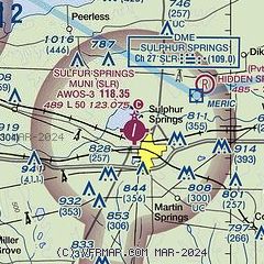
|
| Airport distance calculator |
|---|
|
|
| Sunrise and sunset |
|---|
|
Times for 23-Nov-2025
| | Local
(UTC-6) | | Zulu
(UTC) |
|---|
| Morning civil twilight | | 06:35 | | 12:35 |
| Sunrise | | 07:02 | | 13:02 |
| Sunset | | 17:16 | | 23:16 |
| Evening civil twilight | | 17:43 | | 23:43 |
|
| Current date and time |
|---|
| Zulu (UTC) | 23-Nov-2025 07:22:26 |
|---|
| Local (UTC-6) | 23-Nov-2025 01:22:26 |
|---|
|
| METAR |
|---|
| KSLR | 230655Z AUTO 01004KT 10SM CLR 11/09 A3023 RMK AO2 T01050094 PWINO
|
|
| TAF |
|---|
KTYR
49nm S | 230532Z 2306/2406 00000KT P6SM SKC FM231200 03004KT 6SM BR FEW009 BKN250 FM231500 09006KT P6SM FEW025 BKN250 FM240000 11006KT P6SM SCT060 BKN100 OVC200
|
|
| NOTAMs |
|---|
NOTAMs are issued by the DoD/FAA and will open in a separate window not controlled by AirNav.
|
|


