FAA INFORMATION EFFECTIVE 14 MAY 2026
Location
| FAA Identifier: | F53 |
| Lat/Long: | 33-12-55.2000N 095-14-14.0000W
33-12.920000N 095-14.233333W
33.2153333,-95.2372222
(estimated) |
| Elevation: | 412.1 ft. / 125.6 m (surveyed) |
| Variation: | 06E (1985) |
| From city: | 2 miles NW of MOUNT VERNON, TX |
| Time zone: | UTC -5 (UTC -6 during Standard Time) |
| Zip code: | 75457 |
Airport Operations
| Airport use: | Open to the public |
| Activation date: | 06/1987 |
| Control tower: | no |
| ARTCC: | FORT WORTH CENTER |
| FSS: | FORT WORTH FLIGHT SERVICE STATION |
| NOTAMs facility: | FTW (NOTAM-D service available) |
| Attendance: | UNATND |
| Wind indicator: | lighted |
| Segmented circle: | yes |
| Lights: | SS-SR |
| Beacon: | white-green (lighted land airport)
Operates sunset to sunrise. |
Airport Communications
| CTAF/UNICOM: | 123.0 |
| WX AWOS-3 at OSA (16 nm SE): | 119.775 (903-575-4027) |
| WX AWOS-3 at SLR (20 nm W): | 118.35 (903-885-9605) |
- APCH/DEP SVC PRVDD BY FORT WORTH ARTCC (ZFW) ON FREQS 132.025/317.75 (CUMBY RCAG).
Nearby radio navigation aids
| VOR radial/distance | | VOR name | | Freq | | Var |
|---|
| PRXr145/22.3 | | PARIS VOR/DME | | 113.60 | | 07E |
| NDB name | | Hdg/Dist | | Freq | | Var | | ID |
|---|
| AMBASSADOR | | 344/38.3 | | 404 | | 07E | | ABG | .- -... --. |
Airport Services
Runway Information
Runway 13/31
| Dimensions: | 3900 x 60 ft. / 1189 x 18 m |
| Surface: | asphalt, in excellent condition |
| Weight bearing capacity: | |
| Runway edge lights: | medium intensity |
| RUNWAY 13 | | RUNWAY 31 |
| Latitude: | 33-13.152683N | | 33-12.686418N |
| Longitude: | 095-14.496915W | | 095-13.970002W |
| Elevation: | 395.9 ft. | | 412.1 ft. |
| Traffic pattern: | left | | left |
| Runway heading: | 130 magnetic, 136 true | | 310 magnetic, 316 true |
| Markings: | nonprecision, in good condition | | nonprecision, in good condition |
| Visual slope indicator: | 2-light PAPI on left (3.00 degrees glide path) | | 2-light PAPI on left (3.00 degrees glide path) |
| Touchdown point: | yes, no lights | | yes, no lights |
| Obstructions: | 36 ft. trees, 400 ft. from runway, 250 ft. right of centerline, 5:1 slope to clear | | 46 ft. trees, 1587 ft. from runway, 100 ft. right of centerline, 30:1 slope to clear |
Airport Ownership and Management from official FAA records
| Ownership: | Publicly-owned |
| Owner: | FRANKLIN COUNTY
200 N. KAUFMAN
MOUNT VERNON, TX 75457
Phone 903-537-2342 |
| Manager: | JOHN GANDY
PO BOX 989
MOUNT VERNON, TX 75457
Phone 903-588-2643 |
Additional Remarks
| - | FOR CD CTC FORT WORTH ARTCC AT 817-858-7584. |
Instrument Procedures
NOTE: All procedures below are presented as PDF files. If you need a reader for these files, you should download the free Adobe Reader.NOT FOR NAVIGATION. Please procure official charts for flight.
FAA instrument procedures published for use from 14 May 2026 at 0901Z to 11 June 2026 at 0900Z.
IAPs - Instrument Approach Procedures |
|---|
| RNAV (GPS) RWY 13 | |
download (193KB) |
| RNAV (GPS) RWY 31 | |
download (190KB) |
| NOTE: Special Take-Off Minimums/Departure Procedures apply | |
download (113KB) |
Other nearby airports with instrument procedures:
KOSA - Mount Pleasant Regional Airport (16 nm SE)
F51 - Winnsboro Municipal Airport (17 nm S)
KSLR - Sulphur Springs Municipal Airport (20 nm W)
KPRX - Cox Field Airport (27 nm NW)
KJDD - Wood County Airport/Collins Field (31 nm SW)
|
|

Road maps at:
MapQuest
Bing
Google
| Aerial photo |
|---|
WARNING: Photo may not be current or correct
 Taken in the Spring of 2005
Do you have a better or more recent aerial photo of Franklin County Airport that you would like to share? If so, please send us your photo.
|
| Sectional chart |
|---|
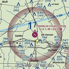
|
| Airport distance calculator |
|---|
|
|
| Sunrise and sunset |
|---|
|
Times for 31-May-2026
| | Local
(UTC-5) | | Zulu
(UTC) |
|---|
| Morning civil twilight | | 05:46 | | 10:46 |
| Sunrise | | 06:14 | | 11:14 |
| Sunset | | 20:23 | | 01:23 |
| Evening civil twilight | | 20:52 | | 01:52 |
|
| Current date and time |
|---|
| Zulu (UTC) | 31-May-2026 05:20:29 |
|---|
| Local (UTC-5) | 31-May-2026 00:20:29 |
|---|
|
| METAR |
|---|
KOSA
16nm SE | 310430Z AUTO 13003KT 10SM CLR 25/23 A2989 RMK AO2 T02480233
|
KPRX
26nm NW | 310455Z AUTO 12006KT 10SM CLR 24/23 A2990 RMK AO2 SLP118 T02440228
|
|
| NOTAMs |
|---|
NOTAMs are issued by the DoD/FAA and will open in a separate window not controlled by AirNav.
|
|

