FAA INFORMATION EFFECTIVE 19 MARCH 2026
Location
| FAA Identifier: | F88 |
| Lat/Long: | 32-12-07.2000N 092-43-58.6000W
32-12.120000N 092-43.976667W
32.2020000,-92.7329444
(estimated) |
| Elevation: | 255.6 ft. / 77.9 m (surveyed) |
| Variation: | 01E (2010) |
| From city: | 3 miles S of JONESBORO, LA |
| Time zone: | UTC -5 (UTC -6 during Standard Time) |
| Zip code: | 71251 |
Airport Operations
| Airport use: | Open to the public |
| Activation date: | 03/1964 |
| Control tower: | no |
| ARTCC: | FORT WORTH CENTER |
| FSS: | DE RIDDER FLIGHT SERVICE STATION |
| NOTAMs facility: | DRI (NOTAM-D service available) |
| Attendance: | UNATNDD |
| Wind indicator: | yes, LGTD WINDSOCK OTS MIDFIELD. |
| Segmented circle: | yes |
| Lights: | REIL RWYS 18 & 36 AND MIRL RWY 18/36, PRESET LOW INTST; TO INCR INTST ACTVT - CTAF. PAPI RWY 36 OTS INDEFLY. |
| Beacon: | white-green (lighted land airport)
Operates sunset to sunrise. |
Airport Communications
| CTAF: | 122.9 |
| MONROE APPROACH: | 126.9 |
| MONROE DEPARTURE: | 126.9 |
- APCH/DEP CTL SVC PRVDD BY FORT WORTH ARTCC (ZFW) ON FREQS 126.325/346.25 (MONROE RCAG) WHEN MONROE APCH CTL (MLU) CLSD.
Nearby radio navigation aids
| NDB name | | Hdg/Dist | | Freq | | Var | | ID |
|---|
| NATCHITOCHES | | 024/37.1 | | 407 | | 04E | | OOC | --- --- -.-. |
Airport Services
| Parking: | tiedowns |
| Airframe service: | NONE |
| Powerplant service: | NONE |
| Bottled oxygen: | NONE |
| Bulk oxygen: | NONE |
Runway Information
Runway 18/36
| Dimensions: | 3204 x 75 ft. / 977 x 23 m |
| Surface: | asphalt, in good condition |
| Weight bearing capacity: | |
| Runway edge lights: | medium intensity |
| RUNWAY 18 | | RUNWAY 36 |
| Latitude: | 32-12.383912N | | 32-11.855510N |
| Longitude: | 092-43.980422W | | 092-43.971602W |
| Elevation: | 248.7 ft. | | 255.5 ft. |
| Traffic pattern: | left | | left |
| Runway heading: | 178 magnetic, 179 true | | 358 magnetic, 359 true |
| Markings: | nonprecision, in good condition | | nonprecision, in good condition |
| Visual slope indicator: | 2-light PAPI on left (3.00 degrees glide path) | | 2-light PAPI on left (3.00 degrees glide path) |
| Runway end identifier lights: | yes | | yes |
| Touchdown point: | yes, no lights | | yes, no lights |
| Obstructions: | 80 ft. trees, 2250 ft. from runway, 25:1 slope to clear | | 85 ft. trees, 2693 ft. from runway, 46 ft. right of centerline, 29:1 slope to clear |
Airport Ownership and Management from official FAA records
| Ownership: | Publicly-owned |
| Owner: | CITY OF JONESBORO
128 ALLEN AVE
JONESBORO, LA 71251
Phone 318-259-2385 |
| Manager: | JAMES BRADFORD
128 ALLEN AVE
JONESBORO, LA 71251
Phone 318-680-8070 |
Additional Remarks
| - | DEER AND WILDLIFE ON & INVOF ARPT. |
| - | SOUTH HOLD LINE NSTD DISTANCE FM RY CNTRLN. |
| - | FOR CD CTC MONROE APCH AT 318-327-5641, IF UNAVBL, CTC FORT WORTH ARTCC AT 817-858-7584. |
| - | CTC APRT MGR FOR DSGND RAMP SPACE FOR PUB USE. |
Instrument Procedures
NOTE: All procedures below are presented as PDF files. If you need a reader for these files, you should download the free Adobe Reader.NOT FOR NAVIGATION. Please procure official charts for flight.
FAA instrument procedures published for use from 19 March 2026 at 0901Z to 16 April 2026 at 0900Z.
IAPs - Instrument Approach Procedures |
|---|
| RNAV (GPS) RWY 18 | |
download (214KB) |
| RNAV (GPS) RWY 36 | |
download (213KB) |
| NOTE: Special Take-Off Minimums/Departure Procedures apply | |
download (116KB) |
Other nearby airports with instrument procedures:
0R5 - David G Joyce Airport (15 nm S)
KRSN - Ruston Regional Airport (20 nm N)
0R7 - The Red River Airport (32 nm SW)
KIER - Natchitoches Regional Airport (34 nm SW)
KMNE - Minden Airport (39 nm NW)
|
|

Road maps at:
MapQuest
Bing
Google
| Aerial photo |
|---|
WARNING: Photo may not be current or correct
 Photo by Ken DeSoto
Photo taken 15-Apr-2014
looking south.
Photo by Ken DeSoto
Photo taken 15-Apr-2014
looking south.
Do you have a better or more recent aerial photo of Jonesboro Airport that you would like to share? If so, please send us your photo.
|
| Sectional chart |
|---|
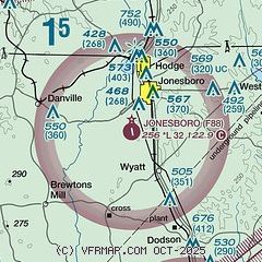
|
| Airport distance calculator |
|---|
|
|
| Sunrise and sunset |
|---|
|
Times for 11-Apr-2026
| | Local
(UTC-5) | | Zulu
(UTC) |
|---|
| Morning civil twilight | | 06:23 | | 11:23 |
| Sunrise | | 06:48 | | 11:48 |
| Sunset | | 19:36 | | 00:36 |
| Evening civil twilight | | 20:01 | | 01:01 |
|
| Current date and time |
|---|
| Zulu (UTC) | 12-Apr-2026 02:37:49 |
|---|
| Local (UTC-5) | 11-Apr-2026 21:37:49 |
|---|
|
| METAR |
|---|
KRSN
20nm N | 120215Z AUTO 17004KT 10SM CLR 20/15 A3016 RMK AO2 T02010149 $
|
KIER
34nm SW | 120215Z AUTO 00000KT 10SM CLR 21/14 A3016 RMK AO2 T02120139 PNO
|
KMNE
39nm NW | 120215Z AUTO 00000KT 10SM CLR 22/12 A3015 RMK AO2
|
KMLU
40nm NE | 120153Z 00000KT 10SM CLR 23/14 A3018 RMK AO2 SLP218 T02280144
|
|
| TAF |
|---|
KMLU
40nm NE | 111739Z 1118/1218 16005KT P6SM SCT045 SCT250 FM120100 VRB03KT P6SM FEW250 FM121200 VRB03KT P6SM BKN250 FM121500 18010KT P6SM BKN250
|
|
| NOTAMs |
|---|
NOTAMs are issued by the DoD/FAA and will open in a separate window not controlled by AirNav.
|
|

