FAA INFORMATION EFFECTIVE 09 JULY 2026
Location
| FAA Identifier: | 0R5 |
| Lat/Long: | 31-57-49.1840N 092-39-36.9380W
31-57.819733N 092-39.615633W
31.9636622,-92.6602606
(estimated) |
| Elevation: | 146 ft. / 44.5 m (surveyed) |
| Variation: | 02E (2010) |
| From city: | 3 miles NW of WINNFIELD, LA |
| Time zone: | UTC -5 (UTC -6 during Standard Time) |
| Zip code: | 71483 |
Airport Operations
| Airport use: | Open to the public |
| Activation date: | 09/1945 |
| Control tower: | no |
| ARTCC: | HOUSTON CENTER |
| FSS: | DE RIDDER FLIGHT SERVICE STATION |
| NOTAMs facility: | DRI (NOTAM-D service available) |
| Attendance: | UNATNDD |
| Wind indicator: | yes |
| Segmented circle: | no |
| Lights: | MIRL RWY 09/27 OPR SS-SR AND PRESET LOW INTST; TO INCR INTST AND ACTVT REIL RWY 09 AND 27 - CTAF. |
| Beacon: | white-green (lighted land airport)
ROTG BCN OBSCURED BY TREES SOUTH, WEST AND EAST. Operates sunset to sunrise. |
Airport Communications
| CTAF/UNICOM: | 122.7 |
| MAKS APPROACH: | 125.4 |
| MAKS DEPARTURE: | 125.4 |
Nearby radio navigation aids
| NDB name | | Hdg/Dist | | Freq | | Var | | ID |
|---|
| NATCHITOCHES | | 045/28.1 | | 407 | | 04E | | OOC | --- --- -.-. |
Airport Services
| Parking: | tiedowns |
| Airframe service: | NONE |
| Powerplant service: | NONE |
| Bottled oxygen: | NONE |
| Bulk oxygen: | NONE |
Runway Information
Runway 9/27
| Dimensions: | 3002 x 100 ft. / 915 x 30 m |
| Surface: | asphalt, in fair condition |
| Weight bearing capacity: | |
| Runway edge lights: | medium intensity |
| RUNWAY 9 | | RUNWAY 27 |
| Latitude: | 31-57.817883N | | 31-57.823033N |
| Longitude: | 092-39.906417W | | 092-39.325583W |
| Elevation: | 146.0 ft. | | 118.0 ft. |
| Traffic pattern: | left | | left |
| Runway heading: | 087 magnetic, 089 true | | 267 magnetic, 269 true |
| Markings: | nonprecision, in fair condition | | nonprecision, in fair condition |
| Visual slope indicator: | 2-light PAPI on left (3.00 degrees glide path) | | 2-light PAPI on left (3.45 degrees glide path) |
| Runway end identifier lights: | yes | | yes |
| Touchdown point: | yes, no lights | | yes, no lights |
| Obstructions: | 101 ft. trees, 3043 ft. from runway, 159 ft. left of centerline, 28:1 slope to clear | | 77 ft. trees, 937 ft. from runway, 178 ft. right of centerline, 9:1 slope to clear |
Airport Ownership and Management from official FAA records
| Ownership: | Publicly-owned |
| Owner: | CITY OF WINNFIELD
PO BOX 509
WINNFIELD, LA 71483
Phone 318-628-3939 |
| Manager: | AUNDRA BASS
PO BOX 509
WINNFIELD, LA 71483
Phone (318) 628-3939 |
Additional Remarks
| - | FOR CD CTC MAKS APCH AT 726-780-0456. |
| - | CTC APRT MGR FOR DSGND RAMP SPACE FOR PUB USE. |
Instrument Procedures
NOTE: All procedures below are presented as PDF files. If you need a reader for these files, you should download the free Adobe Reader.NOT FOR NAVIGATION. Please procure official charts for flight.
FAA instrument procedures published for use from 09 July 2026 at 0901Z to 06 August 2026 at 0900Z.
IAPs - Instrument Approach Procedures |
|---|
| RNAV (GPS) RWY 09 **CHANGED** | |
download (193KB) |
| RNAV (GPS) RWY 27 **CHANGED** | |
download (200KB) |
| NOTE: Special Take-Off Minimums/Departure Procedures apply | |
download (116KB) |
Other nearby airports with instrument procedures:
F88 - Jonesboro Airport (15 nm N)
KIER - Natchitoches Regional Airport (26 nm SW)
0R7 - The Red River Airport (33 nm W)
KRSN - Ruston Regional Airport (33 nm N)
KAEX - Alexandria International Airport (39 nm S)
|
|

Road maps at:
MapQuest
Bing
Google
| Aerial photo |
|---|
WARNING: Photo may not be current or correct
 Photo by Gene Greenlees, MD
Taken in June 2010
Photo by Gene Greenlees, MD
Taken in June 2010
Do you have a better or more recent aerial photo of David G Joyce Airport that you would like to share? If so, please send us your photo.
|
| Sectional chart |
|---|
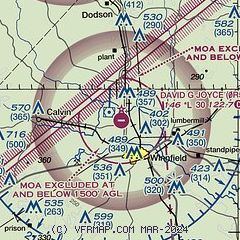
|
| Airport distance calculator |
|---|
|
|
| Sunrise and sunset |
|---|
|
Times for 16-Jul-2026
| | Local
(UTC-5) | | Zulu
(UTC) |
|---|
| Morning civil twilight | | 05:49 | | 10:49 |
| Sunrise | | 06:17 | | 11:17 |
| Sunset | | 20:16 | | 01:16 |
| Evening civil twilight | | 20:44 | | 01:44 |
|
| Current date and time |
|---|
| Zulu (UTC) | 16-Jul-2026 06:23:14 |
|---|
| Local (UTC-5) | 16-Jul-2026 01:23:14 |
|---|
|
| METAR |
|---|
KIER
26nm SW | 160555Z AUTO 00000KT 10SM CLR 23/23 A3011 RMK AO2 T02270227 10298 20226 403220218
|
KRSN
33nm N | 160555Z AUTO 22004KT 10SM SCT130 BKN150 BKN200 22/22 A3010 RMK AO2 60000 T02210221 10228 20219 403180219 51006 $
|
KESF
39nm SE | 160553Z AUTO 00000KT 10SM CLR 23/23 A3010 RMK AO2 SLP191 T02330228 10267 20233 403280222 51005
|
KAQV
44nm SW | 160547Z AUTO 00000KT 7SM CLR 23/22 A3012 RMK AO2 SLP196 T02280222 10278 20228 403170211 51010
|
KMLU
46nm NE | 160553Z AUTO 10SM FEW120 24/21 A3010 RMK AO2 SLP192 T02390211 10283 20239 403280239 51007
|
|
| TAF |
|---|
KAEX
38nm S | 160535Z 1606/1706 VRB02KT P6SM BKN250 TEMPO 1611/1613 00000KT 5SM BR FM161700 20005KT P6SM BKN250 FM170200 16003KT P6SM BKN250
|
KMLU
46nm NE | 160540Z 1606/1706 21003KT P6SM SCT120 BKN250 FM161500 25007KT P6SM SCT035 BKN150 BKN250 FM170100 VRB03KT P6SM SCT200
|
|
| NOTAMs |
|---|
NOTAMs are issued by the DoD/FAA and will open in a separate window not controlled by AirNav.
|
|

