FAA INFORMATION EFFECTIVE 14 MAY 2026
Location
| FAA Identifier: | FCI |
| Lat/Long: | 37-24-23.2000N 077-31-29.4000W
37-24.386667N 077-31.490000W
37.4064444,-77.5248333
(estimated) |
| Elevation: | 236.1 ft. / 72.0 m (surveyed) |
| Variation: | 10W (2005) |
| From city: | 4 miles SW of RICHMOND, VA |
| Time zone: | UTC -4 (UTC -5 during Standard Time) |
| Zip code: | 23237 |
Airport Operations
| Airport use: | Open to the public |
| Activation date: | 06/1973 |
| Control tower: | no |
| ARTCC: | WASHINGTON CENTER |
| FSS: | LEESBURG FLIGHT SERVICE STATION |
| NOTAMs facility: | DCA (NOTAM-D service available) |
| Attendance: | 0700-2200 |
| Pattern altitude: | TPA SINGLE ENGINE ACFT (1000 FT AGL) MULTI ENGINE ACFT (1500 FT AGL). |
| Wind indicator: | lighted |
| Segmented circle: | yes |
| Lights: | HIRL RWY 15/33 PRESET LOW INTST; INCR INTST & ACTVT MALSR RWY 33 & REIL RWY 15 - CTAF. |
| Beacon: | white-green (lighted land airport)
Operates sunset to sunrise. |
| Airline operations: | ARFF INDEX A. |
| International operations: | customs landing rights airport |
Airport Communications
| CTAF/UNICOM: | 123.05 |
| WX AWOS-3PT: | 128.625 (804-271-8426) |
| POTOMAC APPROACH: | 126.75 118.2 |
| POTOMAC DEPARTURE: | 126.75 118.2 |
| CLEARANCE DELIVERY: | 124.6 |
| WX ASOS at RIC (11 nm NE): | PHONE 804-223-6573 |
| WX AWOS-3 at PTB (13 nm S): | 133.325 (804-861-5551) |
| WX ASOS at OFP (19 nm N): | 119.025 (804-752-2902) |
| WX AWOS-3 at W96 (20 nm E): | 119.875 (804-932-8863) |
- APCH/DEP SVC PRVDD BY POTOMAC TRACON 126.75/307.2.
Nearby radio navigation aids
| VOR radial/distance | | VOR name | | Freq | | Var |
|---|
| RICr248/11.3 | | RICHMOND VORTAC | | 114.10 | | 09W |
| FAKr123/16.2 | | FLAT ROCK VORTAC | | 113.30 | | 06W |
| HPWr289/20.0 | | HOPEWELL VORTAC | | 114.35 | | 06W |
| HCMr273/38.8 | | HARCUM VORTAC | | 108.80 | | 07W |
| NDB name | | Hdg/Dist | | Freq | | Var | | ID |
|---|
| BLACKSTONE | | 065/29.9 | | 326 | | 09W | | BKT | -... -.- - |
| WAKEFIELD | | 326/35.7 | | 274 | | 11W | | AKQ | .- -.- --.- |
Airport Services
| Fuel available: | 100LL JET-A
A:FUEL AFT HRS CALL 804-271-7793 OR 844-435-9732 BTN 2200-0700.
100LL:FUEL AFT HRS CALL 804-271-7793 OR 844-435-9732 BTN 2200-0700. |
| Parking: | hangars and tiedowns |
| Airframe service: | MAJOR |
| Powerplant service: | MAJOR |
| Bottled oxygen: | HIGH |
Runway Information
Runway 15/33
| Dimensions: | 5500 x 100 ft. / 1676 x 30 m |
| Surface: | asphalt/grooved, in good condition |
| Weight bearing capacity: | | Single wheel: | 60.0 | | Double wheel: | 80.0 |
|
| Runway edge lights: | high intensity |
| RUNWAY 15 | | RUNWAY 33 |
| Latitude: | 37-24.738788N | | 37-24.033423N |
| Longitude: | 077-31.846680W | | 077-31.133265W |
| Elevation: | 236.1 ft. | | 198.8 ft. |
| Traffic pattern: | left | | left |
| Runway heading: | 151 magnetic, 141 true | | 331 magnetic, 321 true |
| Markings: | nonprecision, in good condition | | precision, in good condition |
| Visual slope indicator: | 4-light PAPI on left (3.00 degrees glide path) | | 4-light PAPI on left (3.00 degrees glide path) |
| Approach lights: | | | MALSR: 1,400 foot medium intensity approach lighting system with runway alignment indicator lights |
| Runway end identifier lights: | yes | | |
| Touchdown point: | yes, no lights | | yes, no lights |
| Instrument approach: | | | ILS/DME |
| Obstructions: | 62 ft. trees, 1997 ft. from runway, 432 ft. right of centerline, 28:1 slope to clear | | 72 ft. trees, 2201 ft. from runway, 606 ft. left of centerline, 27:1 slope to clear |
Airport Ownership and Management from official FAA records
| Ownership: | Publicly-owned |
| Owner: | CHESTERFIELD CO
PO BOX 40
CHESTERFIELD, VA 23832-0040
Phone 804-748-1215
BOARD OF SUPERVISORS. |
| Manager: | JEREMY WILKINSON
7511 AIRFIELD DRIVE
RICHMOND, VA 23237-2252
Phone 804-768-7722 |
Additional Remarks
| - | ACFT ON ILS APCH TO RICHMOND INTL CROSSING OVER ARPT. |
| - | 400 FT TWR 5 NM N ARPT. |
| - | NOISE SENSITIVE AREA NORTH OF ARPT. NO WIND VOLUNTARY USE OF RWY 15 PREFERRED. |
| - | DEER & BIRDS ON & INVOF ARPT. |
| - | HELICOPTER PARKING ADJ TO TWY C. |
| - | MED-FLIGHT: IRREGULAR DEPARTURE PATTERN. |
| - | ARFF EQPT AND TRAINED PERSONNEL AVBL AT ARPT. |
| - | FOR CD CTC POTOMAC APCH AT 866-640-4124. |
Instrument Procedures
NOTE: All procedures below are presented as PDF files. If you need a reader for these files, you should download the free Adobe Reader.NOT FOR NAVIGATION. Please procure official charts for flight.
FAA instrument procedures published for use from 14 May 2026 at 0901Z to 11 June 2026 at 0900Z.
IAPs - Instrument Approach Procedures |
|---|
| ILS OR LOC RWY 33 | |
download (296KB) |
| RNAV (GPS) RWY 15 | |
download (251KB) |
| RNAV (GPS) RWY 33 | |
download (263KB) |
| NOTE: Special Alternate Minimums apply | |
download (166KB) |
| NOTE: Special Take-Off Minimums/Departure Procedures apply | |
download (357KB) |
Other nearby airports with instrument procedures:
KRIC - Richmond International Airport (11 nm NE)
KPTB - Tri Cities Executive/Dinwiddie County Airport (13 nm S)
KOFP - Hanover County Municipal Airport (19 nm N)
W96 - New Kent County Airport (20 nm E)
KBKT - Allan C Perkinson/Blackstone AAF Airport (28 nm SW)
|
|

Road maps at:
MapQuest
Bing
Google
| Aerial photo |
|---|
WARNING: Photo may not be current or correct

Do you have a better or more recent aerial photo of Richmond Executive-Chesterfield County Airport that you would like to share? If so, please send us your photo.
|
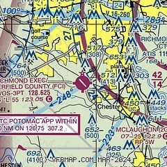
| Sectional chart |
|---|
|
CAUTION: Diagram may not be current

| Airport distance calculator |
|---|
|
|
| Sunrise and sunset |
|---|
|
Times for 10-Jun-2026
| | Local
(UTC-4) | | Zulu
(UTC) |
|---|
| Morning civil twilight | | 05:19 | | 09:19 |
| Sunrise | | 05:50 | | 09:50 |
| Sunset | | 20:29 | | 00:29 |
| Evening civil twilight | | 21:00 | | 01:00 |
|
| Current date and time |
|---|
| Zulu (UTC) | 10-Jun-2026 18:07:42 |
|---|
| Local (UTC-4) | 10-Jun-2026 14:07:42 |
|---|
|
| METAR |
|---|
| KFCI | 101756Z AUTO 22011G16KT 10SM BKN017 28/24 A2997 RMK AO2 SLP155 P0001 60002 T02780239 10278 20239 58017 $
|
KRIC
12nm NE | 101754Z 23015KT 7SM SCT018 SCT045 BKN130 29/22 A2995 RMK AO2 PK WND 22026/1705 SLP143 60000 T02940222 10300 20239 58018
|
KPTB
14nm S | 101755Z AUTO 22008G16KT 10SM SCT019 SCT024 BKN100 28/22 A2997 RMK AO2 P0001 60005 T02840224 10284 20235
|
KOFP
18nm N | 101754Z AUTO 21013G21KT 7SM CLR 31/22 A2995 RMK AO2 SLP138 60001 T03060222 10306 20233 58019
|
KW96
20nm E | 101755Z AUTO 21007KT 10SM SCT023 29/22 A2995 RMK AO1 T02860220 10287 20238
|
|
| TAF |
|---|
KRIC
12nm NE | 101740Z 1018/1118 24014G23KT P6SM BKN040 TEMPO 1020/1022 VRB20G30KT 2SM TSRA BKN030CB FM110000 22007KT P6SM BKN080 FM111400 25008KT P6SM FEW060
|
|
| NOTAMs |
|---|
NOTAMs are issued by the DoD/FAA and will open in a separate window not controlled by AirNav.
|
|


