FAA INFORMATION EFFECTIVE 11 JUNE 2026
Location
| FAA Identifier: | FKR |
| Lat/Long: | 40-16-24.3510N 086-33-43.8130W
40-16.405850N 086-33.730217W
40.2734308,-86.5621703
(estimated) |
| Elevation: | 860.7 ft. / 262.3 m (surveyed) |
| Variation: | 02W (1990) |
| From city: | 3 miles W of FRANKFORT, IN |
| Time zone: | UTC -4 (UTC -5 during Standard Time) |
| Zip code: | 46041 |
Airport Operations
| Airport use: | Open to the public |
| Activation date: | 12/1960 |
| Control tower: | no |
| ARTCC: | CHICAGO CENTER |
| FSS: | TERRE HAUTE FLIGHT SERVICE STATION |
| NOTAMs facility: | HUF (NOTAM-D service available) |
| Attendance: | 0800-1700
SVC AFT HR - AMGR. |
| Wind indicator: | lighted |
| Segmented circle: | no |
| Lights: | ACTVT REIL RWY 09 & 27; MIRL RWY 04/22 & 09/27 - CTAF. MIRL RWY 04/22 & 09/27 PRESET LOW INTST; INCR INTST - CTAF. |
| Beacon: | white-green (lighted land airport)
Operates sunset to sunrise. |
Airport Communications
| CTAF/UNICOM: | 123.0 |
| WX AWOS-3: | 124.325 (765-654-0328) |
| GRISSOM APPROACH: | 123.85 |
| GRISSOM DEPARTURE: | 123.85 |
| WX ASOS at LAF (19 nm NW): | PHONE 765-743-9687 |
- APCH/DEP SVC PRVDD BY CHICAGO ARTCC ON FREQ 123.85 (LAFAYETTE RCAG) WHEN GRISSOM (GUS) APCH/DEP CON CLSD.
Nearby radio navigation aids
| VOR radial/distance | | VOR name | | Freq | | Var |
|---|
| BVTr125/28.7 | | BOILER VORTAC | | 115.10 | | 01E |
| VHPr341/28.9 | | BRICKYARD VORTAC | | 116.30 | | 01E |
| NDB name | | Hdg/Dist | | Freq | | Var | | ID |
|---|
| CRAWFORDSVILLE | | 047/23.9 | | 388 | | 04W | | CFJ | -.-. ..-. .--- |
Airport Services
| Fuel available: | 100LL JET-A |
| Parking: | hangars and tiedowns |
| Airframe service: | MINOR |
| Powerplant service: | MINOR |
Runway Information
Runway 9/27
| Dimensions: | 5000 x 75 ft. / 1524 x 23 m |
| Surface: | asphalt, in good condition |
| Runway edge lights: | medium intensity |
| RUNWAY 9 | | RUNWAY 27 |
| Latitude: | 40-16.360818N | | 40-16.360287N |
| Longitude: | 086-34.133352W | | 086-33.058223W |
| Elevation: | 856.2 ft. | | 860.7 ft. |
| Traffic pattern: | left | | left |
| Runway heading: | 092 magnetic, 090 true | | 272 magnetic, 270 true |
| Markings: | nonprecision, in fair condition | | nonprecision, in fair condition |
| Visual slope indicator: | 2-light PAPI on left (3.00 degrees glide path) | | 2-light PAPI on left (3.00 degrees glide path) |
| Runway end identifier lights: | yes | | yes |
| Touchdown point: | yes, no lights | | yes, no lights |
| Obstructions: | 10 ft. crops, 300 ft. from runway, 10:1 slope to clear
30:1 @ THLD | | none |
Runway 4/22
| Dimensions: | 2527 x 70 ft. / 770 x 21 m |
| Surface: | asphalt, in excellent condition |
| Weight bearing capacity: | | Single wheel: | 12.5 | | Double wheel: | 20.0 |
|
| Runway edge lights: | medium intensity |
| Operational restrictions: | 420 FT SWY NE END. 20 FT WIDE DITCH PERPENDICULAR TO RWY 100 FT W OF CNTRLN. |
| RUNWAY 4 | | RUNWAY 22 |
| Latitude: | 40-16.323067N | | 40-16.667383N |
| Longitude: | 086-34.148417W | | 086-33.843017W |
| Elevation: | 856.6 ft. | | 857.3 ft. |
| Traffic pattern: | left | | left |
| Runway heading: | 036 magnetic, 034 true | | 216 magnetic, 214 true |
| Markings: | nonprecision, in fair condition | | basic, in fair condition |
| Visual slope indicator: | | | 2-light PAPI on right (4.00 degrees glide path) |
| Runway end identifier lights: | no | | no |
| Touchdown point: | yes, no lights | | yes, no lights |
| Obstructions: | 10 ft. crops, 206 ft. from runway
CLNC SLOPE 20:1 @ THLD | | 19 ft. road, 370 ft. from runway, 140 ft. right of centerline, 8:1 slope to clear
CLOSEST INTCP POINT. |
Airport Ownership and Management from official FAA records
| Ownership: | Publicly-owned |
| Owner: | FRANKFORT ARPT AUTH
3009 W STATE ROAD 28
FRANKFORT, IN 46041
Phone 765-654-6275 |
| Manager: | NICK RASMUSSEN
3009 W STATE ROAD 28
FRANKFORT, IN 46041
Phone 765-654-6275 |
Additional Remarks
| - | FOR CD CTC CHICAGO ARTCC AT 630-906-8921. |
| - | COYOTE ON & INVOF ARPT. |
Instrument Procedures
NOTE: All procedures below are presented as PDF files. If you need a reader for these files, you should download the free Adobe Reader.NOT FOR NAVIGATION. Please procure official charts for flight.
FAA instrument procedures published for use from 11 June 2026 at 0901Z to 09 July 2026 at 0900z.
IAPs - Instrument Approach Procedures |
|---|
| RNAV (GPS) RWY 09 | |
download (257KB) |
| RNAV (GPS) RWY 27 | |
download (201KB) |
| NOTE: Special Alternate Minimums apply | |
download (151KB) |
| NOTE: Special Take-Off Minimums/Departure Procedures apply | |
download (501KB) |
Other nearby airports with instrument procedures:
5I4 - Sheridan Airport (17 nm E)
1I9 - Delphi Municipal Airport (17 nm N)
KLAF - Purdue University Airport (19 nm NW)
KTYQ - Indianapolis Executive Airport (20 nm SE)
KCFJ - Crawfordsville Regional Airport (24 nm SW)
|
|

Road maps at:
MapQuest
Bing
Google
| Aerial photo |
|---|
WARNING: Photo may not be current or correct
 Photo by Alexander Vela
Taken in 2015
looking north.
Photo by Alexander Vela
Taken in 2015
looking north.
Do you have a better or more recent aerial photo of Frankfort Clinton County Regional Airport that you would like to share? If so, please send us your photo.
|
| Sectional chart |
|---|
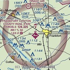
|
CAUTION: Diagram may not be current

| Airport distance calculator |
|---|
|
|
| Sunrise and sunset |
|---|
|
Times for 14-Jun-2026
| | Local
(UTC-4) | | Zulu
(UTC) |
|---|
| Morning civil twilight | | 05:44 | | 09:44 |
| Sunrise | | 06:17 | | 10:17 |
| Sunset | | 21:16 | | 01:16 |
| Evening civil twilight | | 21:49 | | 01:49 |
|
| Current date and time |
|---|
| Zulu (UTC) | 14-Jun-2026 21:42:45 |
|---|
| Local (UTC-4) | 14-Jun-2026 17:42:45 |
|---|
|
| METAR |
|---|
| KFKR | 142115Z AUTO 30015KT 10SM OVC060 21/15 A2987 RMK AO2
|
KLAF
20nm NW | 142054Z 31012G22KT 10SM OVC065 22/14 A2987 RMK AO2 SLP111 T02220139 55001
|
|
| TAF |
|---|
KLAF
20nm NW | 141725Z 1418/1518 31011G21KT P6SM BKN035 FM150000 34003KT P6SM FEW050 FM151400 27004KT P6SM SCT050
|
|
| NOTAMs |
|---|
NOTAMs are issued by the DoD/FAA and will open in a separate window not controlled by AirNav.
|
|


