FAA INFORMATION EFFECTIVE 17 APRIL 2025
Location
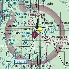
| FAA Identifier: | HPT |
| Lat/Long: | 42-43-25.3000N 093-13-34.8000W
42-43.421667N 093-13.580000W
42.7236944,-93.2263333
(estimated) |
| Elevation: | 1176.3 ft. / 358.5 m (surveyed) |
| Variation: | 03E (1995) |
| From city: | 2 miles SW of HAMPTON, IA |
| Time zone: | UTC -5 (UTC -6 during Standard Time) |
| Zip code: | 50441 |
Airport Operations
| Airport use: | Open to the public |
| Activation date: | 08/1969 |
| Control tower: | no |
| ARTCC: | MINNEAPOLIS CENTER |
| FSS: | FORT DODGE FLIGHT SERVICE STATION |
| NOTAMs facility: | FOD (NOTAM-D service available) |
| Attendance: | MON-FRI 0800-1700
FOR ATTENDANT AFT HRS CALL 641-456-9000 OR 641-456-2529 (POLICE DEPT.) |
| Wind indicator: | lighted |
| Segmented circle: | no |
| Lights: | ACTVT REIL RWY 17 & 35; PAPI RWY 17 & 35; MIRL RWY 17/35 - CTAF. |
| Beacon: | white-green (lighted land airport)
Operates sunset to sunrise. |
Airport Communications
| CTAF/UNICOM: | 122.7 |
| WX AWOS-3: | 121.025 (641-456-4055) |
| WX AWOS-3 at IFA (15 nm S): | 120.425 (641-648-2469) |
- APCH/DEP SVC PRVDD BY MINNEAPOLIS ARTCC ON FREQS 134.0/288.3 (FORT DODGE RCAG).
Nearby radio navigation aids
| VOR radial/distance | | VOR name | | Freq | | Var |
|---|
| MCWr162/22.7 | | MASON CITY VOR/DME | | 114.90 | | 06E |
| ALOr285/37.9 | | WATERLOO VOR/DME | | 112.20 | | 00E |
Airport Services
| Fuel available: | 100LL JET-A |
| Parking: | hangars and tiedowns |
| Airframe service: | MINOR |
| Powerplant service: | MINOR |
| Bottled oxygen: | NONE |
| Bulk oxygen: | NONE |
Runway Information
Runway 17/35
| Dimensions: | 4020 x 75 ft. / 1225 x 23 m |
| Surface: | concrete, in good condition |
| Weight bearing capacity: | | PCN 6 /R/D/W/U | | Single wheel: | 12.0 |
|
| Runway edge lights: | medium intensity |
| RUNWAY 17 | | RUNWAY 35 |
| Latitude: | 42-43.752480N | | 42-43.090682N |
| Longitude: | 093-13.576822W | | 093-13.583128W |
| Elevation: | 1176.3 ft. | | 1159.2 ft. |
| Traffic pattern: | left | | left |
| Runway heading: | 177 magnetic, 180 true | | 357 magnetic, 000 true |
| Markings: | nonprecision, in good condition | | nonprecision, in good condition |
| Visual slope indicator: | 2-light PAPI on left (3.00 degrees glide path) | | 2-light PAPI on left (3.00 degrees glide path) |
| Runway end identifier lights: | yes | | yes |
| Touchdown point: | yes, no lights | | yes, no lights |
| Obstructions: | 17 ft. road, 240 ft. from runway, 220 ft. right of centerline, 2:1 slope to clear | | 19 ft. tree, 284 ft. from runway, 225 ft. left of centerline, 4:1 slope to clear
15 FT TREE, 220 FT W OF APCH END RWY 35, 1:1 APCH SLP. |
Airport Ownership and Management from official FAA records
| Ownership: | Publicly-owned |
| Owner: | CITY OF HAMPTON
122 1ST AVE. NW
HAMPTON, IA 50441
Phone 641-456-4853 |
| Manager: | JAY SCHUMANN
1274 B OLIVE AVE
HAMPTON, IA 50441
Phone 641-456-4102
SCHUMANN AVIATION |
Additional Remarks
| - | FOR CD CTC MINNEAPOLIS ARTCC AT 651-463-5588. |
Instrument Procedures
NOTE: All procedures below are presented as PDF files. If you need a reader for these files, you should download the free Adobe Reader.NOT FOR NAVIGATION. Please procure official charts for flight.
FAA instrument procedures published for use from 17 April 2025 at 0901Z to 15 May 2025 at 0900z.
IAPs - Instrument Approach Procedures |
|---|
| RNAV (GPS) RWY 17 | |
download (209KB) |
| RNAV (GPS) RWY 35 | |
download (219KB) |
| VOR/DME RWY 35 | |
download (179KB) |
| NOTE: Special Take-Off Minimums/Departure Procedures apply | |
download (158KB) |
Other nearby airports with instrument procedures:
KIFA - Iowa Falls Municipal Airport (15 nm S)
KCAV - Clarion Municipal Airport (24 nm W)
KMCW - Mason City Municipal Airport (26 nm N)
KEAG - Eagle Grove Municipal Airport (30 nm W)
C25 - Waverly Municipal Airport (32 nm E)
|
|

Road maps at:
MapQuest
Bing
Google
| Aerial photo |
|---|

|
| Sectional chart |
|---|
|
| Airport distance calculator |
|---|
|
|
| Sunrise and sunset |
|---|
|
Times for 01-May-2025
| | Local
(UTC-5) | | Zulu
(UTC) |
|---|
| Morning civil twilight | | 05:37 | | 10:37 |
| Sunrise | | 06:08 | | 11:08 |
| Sunset | | 20:12 | | 01:12 |
| Evening civil twilight | | 20:43 | | 01:43 |
|
| Current date and time |
|---|
| Zulu (UTC) | 02-May-2025 01:12:47 |
|---|
| Local (UTC-5) | 01-May-2025 20:12:47 |
|---|
|
| METAR |
|---|
| KHPT | 020055Z AUTO 29006KT 10SM CLR 11/10 A2975 RMK AO2
|
KIFA
15nm S | 020055Z AUTO 30011KT 10SM SCT070 14/10 A2977 RMK AO2 T01350098
|
|
| TAF |
|---|
KMCW
26nm N | 012026Z 0120/0218 VRB05KT 5SM -SHRA SCT008 OVC020 FM012200 32011G17KT P6SM VCSH BKN018 OVC028 FM020200 31010KT P6SM SCT030 BKN060 FM021200 32012KT P6SM SCT015 BKN025
|
|
| NOTAMs |
|---|
NOTAMs are issued by the DoD/FAA and will open in a separate window not controlled by AirNav.
|
|


