FAA INFORMATION EFFECTIVE 19 MARCH 2026
Location
| FAA Identifier: | HYW |
| Lat/Long: | 33-49-42.5550N 079-07-19.8348W
33-49.709250N 079-07.330580W
33.8284875,-79.1221763
(estimated) |
| Elevation: | 34.8 ft. / 10.6 m (surveyed) |
| Variation: | 08W (2000) |
| From city: | 3 miles W of CONWAY, SC |
| Time zone: | UTC -4 (UTC -5 during Standard Time) |
| Zip code: | 29527 |
Airport Operations
| Airport use: | Open to the public |
| Control tower: | no |
| ARTCC: | JACKSONVILLE CENTER |
| FSS: | ANDERSON FLIGHT SERVICE STATION |
| NOTAMs facility: | AND (NOTAM-D service available) |
| Attendance: | 0900-1700 |
| Wind indicator: | lighted |
| Segmented circle: | yes |
| Lights: | ACTVT MIRL RWY 04/22 - CTAF. |
| Beacon: | white-green (lighted land airport)
Operates sunset to sunrise. |
Airport Communications
| CTAF/UNICOM: | 122.7 |
| WX AWOS-3: | 119.525 (843-397-8046) |
| MYRTLE BEACH APPROACH: | 127.4 |
| MYRTLE BEACH DEPARTURE: | 127.4 |
| WX AWOS-3PT at MYR (13 nm SE): | 123.925 (843-238-0335) |
| WX ASOS at CRE (20 nm E): | 119.625 (843-361-2802) |
- APCH/DEP SVC PRVDD BY JACKSONVILLE ARTCC ON FREQS 134.375/317.550 (MYRTLE BEACH RCAG) WHEN MYRTLE BEACH CTL CLSD.
Nearby radio navigation aids
| VOR radial/distance | | VOR name | | Freq | | Var |
|---|
| CREr276/19.8 | | GRAND STRAND VORTAC | | 114.40 | | 03W |
| FLOr135/36.0 | | FLORENCE VORTAC | | 115.20 | | 03W |
| NDB name | | Hdg/Dist | | Freq | | Var | | ID |
|---|
| EVANS | | 099/32.1 | | 420 | | 06W | | CFY | -.-. ..-. -.-- |
Airport Services
| Fuel available: | 100LL JET-A JET-A+
100LL:FUEL 24 HR CREDIT CARD SVC AVBL. |
| Parking: | tiedowns |
| Airframe service: | MAJOR |
| Powerplant service: | MAJOR |
| Bottled oxygen: | NONE |
| Bulk oxygen: | NONE |
Runway Information
Runway 4/22
| Dimensions: | 4401 x 75 ft. / 1341 x 23 m |
| Surface: | asphalt, in good condition |
| Weight bearing capacity: | | Single wheel: | 12.5 | | Double wheel: | 20.0 |
|
| Runway edge lights: | medium intensity |
| RUNWAY 4 | | RUNWAY 22 |
| Latitude: | 33-49.400977N | | 33-50.017522N |
| Longitude: | 079-07.559822W | | 079-07.101337W |
| Elevation: | 33.3 ft. | | 34.5 ft. |
| Traffic pattern: | left | | left |
| Runway heading: | 040 magnetic, 032 true | | 220 magnetic, 212 true |
| Markings: | nonprecision, in good condition | | nonprecision, in good condition |
| Visual slope indicator: | 4-light PAPI on right (3.35 degrees glide path) | | 4-light PAPI on left (3.00 degrees glide path) |
| Runway end identifier lights: | yes | | yes |
| Touchdown point: | yes, no lights | | yes, no lights |
| Obstructions: | 89 ft. tree, 1776 ft. from runway, 220 ft. left of centerline, 17:1 slope to clear | | 76 ft. tree, 2013 ft. from runway, 449 ft. right of centerline, 23:1 slope to clear |
Airport Ownership and Management from official FAA records
| Ownership: | Publicly-owned |
| Owner: | HORRY COUNTY
PO BOX 1236
CONWAY, SC 29526
Phone 843-397-9111 |
| Manager: | JUDI OLMSTEAD
1100 JETPORT RD
MYRTLE BEACH, SC 29577
Phone 843-448-1580 |
Additional Remarks
| - | FOR CD CTC MYRTLE BEACH APCH AT 843-477-2727 OR 843-477-2704, WHEN APCH CLSD CTC JACKSONVILLE ARTCC AT 904-845-1592. |
Instrument Procedures
NOTE: All procedures below are presented as PDF files. If you need a reader for these files, you should download the free Adobe Reader.NOT FOR NAVIGATION. Please procure official charts for flight.
FAA instrument procedures published for use from 19 March 2026 at 0901Z to 16 April 2026 at 0900Z.
IAPs - Instrument Approach Procedures |
|---|
| RNAV (GPS) RWY 04 | |
download (247KB) |
| RNAV (GPS) RWY 22 | |
download (228KB) |
| NOTE: Special Alternate Minimums apply | |
download (25KB) |
| NOTE: Special Take-Off Minimums/Departure Procedures apply | |
download (141KB) |
Other nearby airports with instrument procedures:
KMYR - Myrtle Beach International Airport (13 nm SE)
KCRE - Grand Strand Airport (20 nm E)
5J9 - Twin City Airport (20 nm NE)
KMAO - Marion County Airport (24 nm NW)
KPHH - Robert F Swinnie Airport (30 nm SW)
|
|

Road maps at:
MapQuest
Bing
Google
| Aerial photo |
|---|
WARNING: Photo may not be current or correct

Do you have a better or more recent aerial photo of Conway-Horry County Airport that you would like to share? If so, please send us your photo.
|
| Sectional chart |
|---|
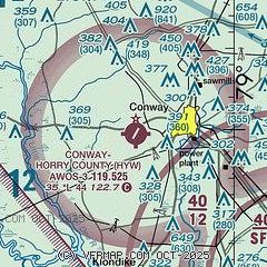
|
| Airport distance calculator |
|---|
|
|
| Sunrise and sunset |
|---|
|
Times for 14-Apr-2026
| | Local
(UTC-4) | | Zulu
(UTC) |
|---|
| Morning civil twilight | | 06:22 | | 10:22 |
| Sunrise | | 06:48 | | 10:48 |
| Sunset | | 19:46 | | 23:46 |
| Evening civil twilight | | 20:11 | | 00:11 |
|
| Current date and time |
|---|
| Zulu (UTC) | 14-Apr-2026 08:58:16 |
|---|
| Local (UTC-4) | 14-Apr-2026 04:58:16 |
|---|
|
| METAR |
|---|
| KHYW | 140835Z AUTO 00000KT 10SM CLR 13/13 A3021 RMK AO2
|
KMYR
14nm SE | 140853Z AUTO 25004KT 10SM CLR 17/16 A3022 RMK AO2 SLP233 T01670156 55004 $
|
|
| TAF |
|---|
KMYR
14nm SE | 140526Z 1406/1506 22006KT P6SM SKC FM141700 19015G24KT P6SM FEW250 FM150200 20008KT P6SM SKC
|
|
| NOTAMs |
|---|
NOTAMs are issued by the DoD/FAA and will open in a separate window not controlled by AirNav.
|
|

