FAA INFORMATION EFFECTIVE 22 JANUARY 2026
Location
| FAA Identifier: | HYX |
| Lat/Long: | 43-26-00.1480N 083-51-44.2870W
43-26.002467N 083-51.738117W
43.4333744,-83.8623019
(estimated) |
| Elevation: | 601.5 ft. / 183.3 m (surveyed) |
| Variation: | 07W (2020) |
| From city: | 4 miles E of SAGINAW, MI |
| Time zone: | UTC -5 (UTC -4 during Daylight Saving Time) |
| Zip code: | 48601 |
Airport Operations
| Airport use: | Open to the public |
| Activation date: | 04/1940 |
| Control tower: | no |
| ARTCC: | CLEVELAND CENTER |
| FSS: | LANSING FLIGHT SERVICE STATION |
| NOTAMs facility: | HYX (NOTAM-D service available) |
| Attendance: | MON-FRI 0730-1700, ALL SAT-SUN 0800-1200
UNATNDD MAJOR HOLS. |
| Wind indicator: | lighted |
| Segmented circle: | no |
| Lights: | ACTVT MALSF RWY 28; REIL RWY 10; PAPI RWY 05, 23, 10, & 28; HIRL RWY 10/28; MIRL RWY 05/23 - CTAF. PAPI RWY 10 & 28 OPR CONSLY DURG DALGT HRS. |
| Beacon: | white-green (lighted land airport)
Operates sunset to sunrise. |
Airport Communications
| CTAF/UNICOM: | 122.8 |
| WX AWOS-3PT: | 118.325 (989-752-3408) |
| GREAT LAKES APPROACH: | 120.95 |
| GREAT LAKES DEPARTURE: | 120.95 |
| WX ASOS at MBS (11 nm NW): | PHONE 989-695-2488 |
| WX AWOS-3 at CFS (18 nm E): | 119.275 (989-672-4182) |
- APCH/DEP SVC PRVDD BY CLEVELAND ARTCC (ZOB) ON FREQS 127.7/290.425 (FREELAND RCAG) WHEN GREAT LAKES APCH CTL CLSD.
Nearby radio navigation aids
| VOR radial/distance | | VOR name | | Freq | | Var |
|---|
| MBSr125/11.1 | | SAGINAW VOR/DME | | 114.35 | | 03W |
| FNTr356/28.4 | | FLINT VORTAC | | 116.90 | | 06W |
| MOPr112/39.7 | | MOUNT PLEASANT VOR/DME | | 110.60 | | 05W |
| NDB name | | Hdg/Dist | | Freq | | Var | | ID |
|---|
| OLSTE | | 104/13.9 | | 257 | | 07W | | MB | -- -... |
Airport Services
| Fuel available: | 100LL JET-A+
100LL:100LL & JET A+ AVBL H24 SELF SVC. |
| Parking: | tiedowns |
| Airframe service: | MAJOR |
| Powerplant service: | MAJOR |
Runway Information
Runway 10/28
| Dimensions: | 5002 x 100 ft. / 1525 x 30 m |
| Surface: | asphalt, in excellent condition |
| Weight bearing capacity: | | Single wheel: | 60.0 | | Double wheel: | 72.0 | | Double tandem: | 101.0 |
|
| Runway edge lights: | high intensity |
| RUNWAY 10 | | RUNWAY 28 |
| Latitude: | 43-26.034315N | | 43-26.035343N |
| Longitude: | 083-52.312800W | | 083-51.182965W |
| Elevation: | 598.7 ft. | | 597.3 ft. |
| Traffic pattern: | left | | left |
| Runway heading: | 097 magnetic, 090 true | | 277 magnetic, 270 true |
| Markings: | nonprecision, in good condition | | precision, in good condition |
| Visual slope indicator: | 4-light PAPI on left (3.00 degrees glide path) | | 4-light PAPI on left (3.00 degrees glide path) |
| Approach lights: | | | MALSF: 1,400 foot medium intensity approach lighting system with sequenced flashers |
| Runway end identifier lights: | yes | | no |
| Touchdown point: | yes, no lights | | yes, no lights |
| Instrument approach: | | | ILS/DME |
| Obstructions: | 4 ft. brush, 229 ft. from runway, 313 ft. right of centerline, 7:1 slope to clear | | 66 ft. trees, 842 ft. from runway, 620 ft. left of centerline, 9:1 slope to clear |
Runway 5/23
| Dimensions: | 2952 x 60 ft. / 900 x 18 m |
| Surface: | asphalt, in good condition |
| Weight bearing capacity: | |
| Runway edge lights: | medium intensity |
| RUNWAY 5 | | RUNWAY 23 |
| Latitude: | 43-25.774612N | | 43-26.120580N |
| Longitude: | 083-51.955610W | | 083-51.487470W |
| Elevation: | 600.8 ft. | | 597.9 ft. |
| Traffic pattern: | left | | left |
| Runway heading: | 052 magnetic, 045 true | | 232 magnetic, 225 true |
| Displaced threshold: | 119 ft. | | 129 ft. |
| Markings: | basic, in good condition | | basic, in good condition |
| Visual slope indicator: | 2-light PAPI on left (3.00 degrees glide path) | | 2-light PAPI on right (3.00 degrees glide path) |
| Touchdown point: | yes, no lights | | yes, no lights |
| Obstructions: | 6 ft. fence, 200 ft. from runway, 120 ft. right of centerline, 1:1 slope to clear
APCH RATIO 20:1 TO DTHR. | | 15 ft. road, 210 ft. from runway, 126 ft. right of centerline, 1:1 slope to clear
2 FT CONC CULVERT, 100 FT DIST, 80 FT L; -15 FT DITCH, ACRS APCH END. |
Airport Ownership and Management from official FAA records
| Ownership: | Publicly-owned |
| Owner: | COUNTY OF SAGINAW
4821 JANES RD
SAGINAW, MI 48601-9656
Phone 989-758-2459 |
| Manager: | ALAN KAUFMAN
4789 JANES RD
SAGINAW, MI 48601
Phone 989-295-0675 |
Additional Remarks
| - | DEER & LRG BIRDS ON & INVOF ARPT. |
| - | FOR CD CTC GREAT LAKES APCH AT 269-459-3345, WHEN APCH CLSD CTC CLEVELAND ARTCC AT 440-774-0224/0490. |
Instrument Procedures
NOTE: All procedures below are presented as PDF files. If you need a reader for these files, you should download the free Adobe Reader.NOT FOR NAVIGATION. Please procure official charts for flight.
FAA instrument procedures published for use from 22 January 2026 at 0901Z to 19 February 2026 at 0900z.
IAPs - Instrument Approach Procedures |
|---|
| ILS OR LOC RWY 28 | |
download (230KB) |
| RNAV (GPS) RWY 10 | |
download (225KB) |
| RNAV (GPS) RWY 28 | |
download (237KB) |
| VOR/DME-A | |
download (194KB) |
| NOTE: Special Alternate Minimums apply **CHANGED** | |
download (139KB) |
| NOTE: Special Take-Off Minimums/Departure Procedures apply | |
download (349KB) |
Other nearby airports with instrument procedures:
3CM - James Clements Municipal Airport (7 nm N)
KMBS - MBS International Airport (11 nm NW)
KCFS - Tuscola Area Airport (18 nm E)
KIKW - Jack Barstow Airport (22 nm NW)
KFNT - Bishop International Airport (29 nm S)
|
|

Road maps at:
MapQuest
Bing
Google
| Aerial photo |
|---|
WARNING: Photo may not be current or correct
 As seen circa 2017
looking east.
As seen circa 2017
looking east.
Do you have a better or more recent aerial photo of Saginaw County/H W Browne Airport that you would like to share? If so, please send us your photo.
|
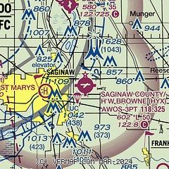
| Sectional chart |
|---|
|
| Airport distance calculator |
|---|
|
|
| Sunrise and sunset |
|---|
|
Times for 03-Feb-2026
| | Local
(UTC-5) | | Zulu
(UTC) |
|---|
| Morning civil twilight | | 07:20 | | 12:20 |
| Sunrise | | 07:50 | | 12:50 |
| Sunset | | 17:48 | | 22:48 |
| Evening civil twilight | | 18:19 | | 23:19 |
|
| Current date and time |
|---|
| Zulu (UTC) | 03-Feb-2026 20:01:09 |
|---|
| Local (UTC-5) | 03-Feb-2026 15:01:09 |
|---|
|
| METAR |
|---|
| KHYX | 031955Z AUTO 32011KT 10SM OVC031 M06/M12 A3019 RMK AO2
|
KMBS
11nm NW | 031953Z 34008KT 10SM OVC030 M06/M12 A3019 RMK AO2 SLP234 T10611122
|
KCFS
18nm E | 031955Z AUTO 29010KT 10SM OVC028 M07/M12 A3018 RMK AO2
|
|
| TAF |
|---|
KMBS
11nm NW | 031737Z 0318/0418 33009KT 6SM -SN BKN035 OVC045 TEMPO 0318/0320 BKN025 OVC045 FM032000 33008KT P6SM BKN045 FM040900 35004KT P6SM OVC028 FM041700 34007KT P6SM BKN035
|
|
| NOTAMs |
|---|
NOTAMs are issued by the DoD/FAA and will open in a separate window not controlled by AirNav.
|
|

