FAA INFORMATION EFFECTIVE 16 APRIL 2026
Location
| FAA Identifier: | FNT |
| Lat/Long: | 42-57-55.6700N 083-44-41.0570W
42-57.927833N 083-44.684283W
42.9654639,-83.7447381
(estimated) |
| Elevation: | 782.1 ft. / 238.4 m (surveyed) |
| Variation: | 06W (2000) |
| From city: | 3 miles SW of FLINT, MI |
| Time zone: | UTC -4 (UTC -5 during Standard Time) |
| Zip code: | 48507 |
Airport Operations
| Airport use: | Open to the public |
| Activation date: | 04/1940 |
| Control tower: | yes |
| ARTCC: | CLEVELAND CENTER |
| FSS: | LANSING FLIGHT SERVICE STATION |
| NOTAMs facility: | FNT (NOTAM-D service available) |
| Attendance: | CONTINUOUS |
| Wind indicator: | lighted |
| Segmented circle: | yes |
| Lights: | WHEN ATCT CLSD ACTVT MALSR RWY 09 & 27; REIL RWY 18 & 36; HIRL RWY 09/27 & 18/36 - CTAF. |
| Beacon: | white-green (lighted land airport)
Operates sunset to sunrise. |
| Fire and rescue: | ARFF index B |
| International operations: | customs landing rights airport |
Airport Communications
| CTAF: | 126.3 |
| UNICOM: | 122.95 |
| ATIS: | 133.15 |
| WX ASOS: | PHONE 810-202-2914 |
| FLINT GROUND: | 121.9 [0545-2330] |
| FLINT TOWER: | 126.3 257.9 [0545-2330] |
| GREAT LAKES APPROACH: | 118.8 |
| CLEVELAND ARTCC APPROACH: | 128.55 |
| GREAT LAKES DEPARTURE: | 118.8 |
| CLEVELAND ARTCC DEPARTURE: | 128.55 |
| CLEARANCE DELIVERY: | 121.75 |
| CLASS C: | 118.8 |
| CLASS C/S: | 128.55 |
| WX AWOS-3P at RNP (17 nm W): | 118.025 (989-729-2967) |
- EMERG FREQS NOT AVBL AT TWR.
- APCH/DEP SVC PRVDD BY CLEVELAND ARTCC (ZOB) ON FREQS 126.75/348.75 (FLINT RCAG) WHEN GREAT LAKES APCH CTL CLSD.
Nearby radio navigation aids
| VOR radial/distance | | VOR name | | Freq | | Var |
|---|
| FNT at field | | FLINT VORTAC | | 116.90 | | 06W |
| SVMr352/34.1 | | SALEM VORTAC | | 114.30 | | 03W |
| MBSr160/36.9 | | SAGINAW VOR/DME | | 114.35 | | 03W |
Airport Services
| Fuel available: | 100LL JET-A
100LL:100LL AVBL SELF SVC AT GOLF TEES. |
| Parking: | hangars and tiedowns |
| Airframe service: | MAJOR |
| Powerplant service: | MAJOR |
| Bottled oxygen: | NONE |
Runway Information
Runway 18/36
| Dimensions: | 7852 x 150 ft. / 2393 x 46 m |
| Surface: | asphalt/grooved, in good condition |
| Weight bearing capacity: | | Single wheel: | 120.0 | | Double wheel: | 250.0 | | Double tandem: | 550.0 |
|
| Runway edge lights: | high intensity |
| RUNWAY 18 | | RUNWAY 36 |
| Latitude: | 42-58.364170N | | 42-57.071822N |
| Longitude: | 083-44.607380W | | 083-44.580532W |
| Elevation: | 763.9 ft. | | 779.0 ft. |
| Traffic pattern: | left | | left |
| Runway heading: | 185 magnetic, 179 true | | 005 magnetic, 359 true |
| Displaced threshold: | 202 ft. | | no |
| Declared distances: | TORA:7852 TODA:7852 ASDA:7852 LDA:7650 | | TORA:7852 TODA:7852 ASDA:7652 LDA:7652 |
| Markings: | nonprecision, in good condition | | nonprecision, in good condition |
| Visual slope indicator: | 4-light PAPI on right (3.00 degrees glide path)
PAPI UNUSBL BYD 8 DEGS LEFT OF CNTRLN. | | 4-light PAPI on left (3.00 degrees glide path) |
| Runway end identifier lights: | yes | | yes |
| Touchdown point: | yes, no lights | | yes, no lights |
| Obstructions: | 79 ft. tree, 2229 ft. from runway, 299 ft. left of centerline, 25:1 slope to clear
APCH RATIO 28:1 TO DTHR. | | 69 ft. tree, 1945 ft. from runway, 485 ft. left of centerline, 25:1 slope to clear |
Runway 9/27
| Dimensions: | 7201 x 150 ft. / 2195 x 46 m |
| Surface: | asphalt/grooved, in good condition |
| Weight bearing capacity: | | Single wheel: | 120.0 | | Double wheel: | 250.0 | | Double tandem: | 550.0 |
|
| Runway edge lights: | high intensity |
| RUNWAY 9 | | RUNWAY 27 |
| Latitude: | 42-58.138510N | | 42-58.174615N |
| Longitude: | 083-45.589523W | | 083-43.976063W |
| Elevation: | 763.8 ft. | | 762.5 ft. |
| Traffic pattern: | left | | left |
| Runway heading: | 094 magnetic, 088 true | | 274 magnetic, 268 true |
| Declared distances: | TORA:7201 TODA:7201 ASDA:7201 LDA:7201 | | TORA:7201 TODA:7201 ASDA:7201 LDA:7201 |
| Markings: | precision, in good condition | | precision, in good condition |
| Visual slope indicator: | 4-light PAPI on right (3.00 degrees glide path) | | 4-light PAPI on left (3.00 degrees glide path) |
| RVR equipment: | touchdown | | rollout |
| Approach lights: | MALSR: 1,400 foot medium intensity approach lighting system with runway alignment indicator lights | | MALSR: 1,400 foot medium intensity approach lighting system with runway alignment indicator lights |
| Runway end identifier lights: | no | | no |
| Touchdown point: | yes, no lights | | yes, no lights |
| Instrument approach: | ILS | | ILS |
| Obstructions: | 60 ft. trees, 2460 ft. from runway, 540 ft. left of centerline, 37:1 slope to clear | | 76 ft. trees, 2968 ft. from runway, 98 ft. right of centerline, 36:1 slope to clear |
Airport Ownership and Management from official FAA records
| Ownership: | Publicly-owned |
| Owner: | BISHOP INTL ARPT AUTH
G-3425 W BRISTOL RD
FLINT, MI 48507
Phone 810-235-6560 |
| Manager: | NINO SAPONE
G-3425 W BRISTOL RD
FLINT, MI 48507
Phone 810-701-0992 |
Additional Remarks
| A39-18/36 | PCR VALUE: 850/F/A/W/T |
| A39-09/27 | PCR VALUE: 800/F/A/W/T |
| - | BIRDS & DEER ON & INVOF ARPT. |
| - | FOR CD WHEN ATCT CLSD CTC GREAT LAKES APCH AT 269-459-3345, WHEN APCH CLSD CTC CLEVELAND ARTCC AT 440-774-0224/0490. |
Instrument Procedures
NOTE: All procedures below are presented as PDF files. If you need a reader for these files, you should download the free Adobe Reader.NOT FOR NAVIGATION. Please procure official charts for flight.
FAA instrument procedures published for use from 16 April 2026 at 0901Z to 14 May 2026 at 0900Z.
STARs - Standard Terminal Arrivals |
|---|
| FOREY TWO (RNAV) | |
download (160KB) |
IAPs - Instrument Approach Procedures |
|---|
| ILS OR LOC RWY 09 | |
download (259KB) |
| ILS OR LOC RWY 27 | |
download (243KB) |
| RNAV (GPS) RWY 09 | |
download (252KB) |
| RNAV (GPS) RWY 18 | |
download (250KB) |
| RNAV (GPS) RWY 27 | |
download (255KB) |
| RNAV (GPS) RWY 36 | |
download (244KB) |
| VOR RWY 18 | |
download (187KB) |
| VOR RWY 36 | |
download (185KB) |
| NOTE: Special Alternate Minimums apply | |
download (139KB) |
| NOTE: Special Take-Off Minimums/Departure Procedures apply | |
download (122KB) |
Other nearby airports with instrument procedures:
9G2 - Price's Airport (10 nm S)
KRNP - Owosso Community Airport (17 nm W)
D95 - Dupont/Lapeer Airport (22 nm E)
KOZW - Livingston County/Spencer J Hardy Airport (23 nm SW)
KPTK - Oakland County International Airport (23 nm SE)
|
|

Road maps at:
MapQuest
Bing
Google
| Aerial photo |
|---|
WARNING: Photo may not be current or correct
 Photo courtesy of Bishop International Airport
Photo taken 06-Oct-2010
looking north.
Photo courtesy of Bishop International Airport
Photo taken 06-Oct-2010
looking north.
Do you have a better or more recent aerial photo of Bishop International Airport that you would like to share? If so, please send us your photo.
|
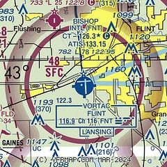
| Sectional chart |
|---|
|
 Download PDF
of official airport diagram from the FAA
| Airport distance calculator |
|---|
|
|
| Sunrise and sunset |
|---|
|
Times for 08-May-2026
| | Local
(UTC-4) | | Zulu
(UTC) |
|---|
| Morning civil twilight | | 05:49 | | 09:49 |
| Sunrise | | 06:21 | | 10:21 |
| Sunset | | 20:42 | | 00:42 |
| Evening civil twilight | | 21:14 | | 01:14 |
|
| Current date and time |
|---|
| Zulu (UTC) | 08-May-2026 18:46:37 |
|---|
| Local (UTC-4) | 08-May-2026 14:46:37 |
|---|
|
| METAR |
|---|
| KFNT | 081753Z 29008KT 10SM CLR 15/M02 A2981 RMK AO2 SLP098 T01501017 10156 20056 58018
|
KRNP
17nm W | 081835Z AUTO 25007KT 10SM CLR 16/M06 A2980 RMK AO2 T01621065
|
|
| TAF |
|---|
| KFNT | 081720Z 0818/0918 25012KT P6SM SCT070 SCT250 FM082300 22005KT P6SM SCT250 FM091000 22010KT P6SM SCT012 BKN040 OVC080 PROB30 0912/0915 6SM -SHRA SCT025 OVC040 FM091600 26016G27KT P6SM BKN100
|
|
| NOTAMs |
|---|
NOTAMs are issued by the DoD/FAA and will open in a separate window not controlled by AirNav.
|
|


