FAA INFORMATION EFFECTIVE 15 MAY 2025
Location
| FAA Identifier: | IWI |
| Lat/Long: | 43-57-41.1000N 069-42-45.2000W
43-57.685000N 069-42.753333W
43.9614167,-69.7125556
(estimated) |
| Elevation: | 70.2 ft. / 21.4 m (surveyed) |
| Variation: | 18W (1985) |
| From city: | 3 miles SW of WISCASSET, ME |
| Time zone: | UTC -4 (UTC -5 during Standard Time) |
| Zip code: | 04578 |
Airport Operations
| Airport use: | Open to the public |
| Activation date: | 09/1960 |
| Control tower: | no |
| ARTCC: | BOSTON CENTER |
| FSS: | BANGOR FLIGHT SERVICE STATION |
| NOTAMs facility: | IWI (NOTAM-D service available) |
| Attendance: | MAY-LABOR DAY 0800-1600, SEP-NOV FRI-SUN 0900-1600, JAN-MAR/NOT ATTENDED/, DEC-APR SAT-SUN 1000-1400 |
| Wind indicator: | lighted |
| Segmented circle: | yes |
| Lights: | ACTVT REIL RWY 25; PAPI RWY 07 & 25; MIRL RWY 07/25 - CTAF. |
| Beacon: | white-green (lighted land airport)
Operates sunset to sunrise. |
Airport Communications
| CTAF/UNICOM: | 122.8 |
| WX ASOS: | 135.725 (207-882-8094) |
| PORTLAND APPROACH: | 119.75 ;112-292 120.4 ;293-111 [0545-0000] |
| PORTLAND DEPARTURE: | 119.75 ;112-292 120.4 ;293-111 [0545-0000] |
| WX AWOS-3PT at BXM (11 nm SW): | 134.875 (207-409-1747) |
- APCH/DEP SVC PRVDD BY BOSTON ARTCC ON FREQS 128.2/263.05 (112-292) (WATERBORO RCAG); FREQS 124.25/290.50 (293-111) (BANGOR RCAG) WHEN PORTLAND APCH CTL CLSD.
Nearby radio navigation aids
| VOR radial/distance | | VOR name | | Freq | | Var |
|---|
| AUGr188/21.8 | | AUGUSTA VOR/DME | | 114.95 | | 18W |
Airport Services
| Fuel available: | 100LL JET-A1+
100LL:24 HR CREDIT CARD FUEL OPN. |
| Parking: | hangars and tiedowns |
| Airframe service: | NONE |
| Powerplant service: | NONE |
| Bottled oxygen: | NONE |
| Bulk oxygen: | NONE |
Runway Information
Runway 7/25
| Dimensions: | 3397 x 75 ft. / 1035 x 23 m |
| Surface: | asphalt, in excellent condition |
| Weight bearing capacity: | |
| Runway edge lights: | medium intensity |
| RUNWAY 7 | | RUNWAY 25 |
| Latitude: | 43-57.511470N | | 43-57.857812N |
| Longitude: | 069-43.057600W | | 069-42.450080W |
| Elevation: | 70.1 ft. | | 55.8 ft. |
| Traffic pattern: | left | | right |
| Runway heading: | 070 magnetic, 052 true | | 250 magnetic, 232 true |
| Markings: | nonprecision, in good condition | | nonprecision, in good condition |
| Visual slope indicator: | 4-light PAPI on right (4.00 degrees glide path) | | 4-light PAPI on left (3.50 degrees glide path) |
| Runway end identifier lights: | no | | yes |
| Touchdown point: | yes, no lights | | yes, no lights |
| Obstructions: | 12 ft. pole, lighted, 262 ft. from runway, 253 ft. right of centerline, 5:1 slope to clear | | 5 ft. tree, 255 ft. from runway, 200 ft. right of centerline, 11:1 slope to clear
SCRUB BRUSH 60-100 FT FM RWY END, 80-200 FT R; SCRUB BRUSH 20-43 FT FM RWY END, 140-210 FT L. |
Airport Ownership and Management from official FAA records
| Ownership: | Publicly-owned |
| Owner: | TOWN OF WISCASSET
51 BATH RD
WISCASSET, ME 04578
Phone (207) 882-8200 |
| Manager: | RICK TETREV
96 CHEWONKI NECK ROAD, 51 BATH RD
WISCASSET, ME 04578
Phone (207) 882-5475
EMAIL: AIRPORT@WISCASSET.ORG. EMERG CTC: 207-882-8202 (TOWN DISPATCHER). |
Additional Remarks
| - | NOISE SENSITIVE AREA SOUTHWEST OFF EOR 07, CLIMB STRAIGHT OUT TO 700 FT AGL. |
| - | DEER AND WILDLIFE ON & INVOF ARPT. |
| - | RWY 7 APCH OBSTN LGTS ON 60 FT. POLES ALG RIGHT SIDE OF APCH LCTD IN 60 FT. TO 70 FT. TALL TREES. |
| - | FOR CD CTC PORTLAND APCH AT 207-874-7320. WHEN PORTLAND APCH CLSD, CTC BOSTON ARTCC AT 603-879-6859. |
Instrument Procedures
NOTE: All procedures below are presented as PDF files. If you need a reader for these files, you should download the free Adobe Reader.NOT FOR NAVIGATION. Please procure official charts for flight.
FAA instrument procedures published for use from 15 May 2025 at 0901Z to 13 June 2025 at 0900z.
IAPs - Instrument Approach Procedures |
|---|
| RNAV (GPS) RWY 07 | |
download (210KB) |
| RNAV (GPS) RWY 25 | |
download (212KB) |
| NOTE: Special Alternate Minimums apply | |
download (57KB) |
| NOTE: Special Take-Off Minimums/Departure Procedures apply | |
download (178KB) |
Other nearby airports with instrument procedures:
KBXM - Brunswick Executive Airport (11 nm SW)
KAUG - Augusta State Airport (22 nm N)
KLEW - Auburn/Lewiston Municipal Airport (25 nm W)
KRKD - Knox County Regional Airport (27 nm E)
KPWM - Portland International Jetport (32 nm SW)
|
|

Road maps at:
MapQuest
Bing
Google
| Aerial photo |
|---|
WARNING: Photo may not be current or correct
 Taken early January 2015
looking southeast.
Taken early January 2015
looking southeast.
Do you have a better or more recent aerial photo of Wiscasset Airport that you would like to share? If so, please send us your photo.
|
| Sectional chart |
|---|
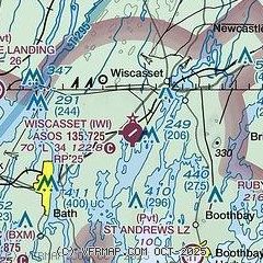
|
| Airport distance calculator |
|---|
|
|
| Sunrise and sunset |
|---|
|
Times for 23-May-2025
| | Local
(UTC-4) | | Zulu
(UTC) |
|---|
| Morning civil twilight | | 04:32 | | 08:32 |
| Sunrise | | 05:06 | | 09:06 |
| Sunset | | 20:05 | | 00:05 |
| Evening civil twilight | | 20:39 | | 00:39 |
|
| Current date and time |
|---|
| Zulu (UTC) | 23-May-2025 05:45:02 |
|---|
| Local (UTC-4) | 23-May-2025 01:45:02 |
|---|
|
| METAR |
|---|
| KIWI | 230528Z AUTO 05006KT 4SM +RA BR BKN014 OVC020 07/06 A2982 RMK AO2 P0018 T00720056
|
KBXM
11nm SW | 230535Z AUTO 04012G17KT 6SM RA BR BKN008 OVC013 07/06 A2981 RMK AO2
|
|
| NOTAMs |
|---|
NOTAMs are issued by the DoD/FAA and will open in a separate window not controlled by AirNav.
|
|


