FAA INFORMATION EFFECTIVE 15 MAY 2025
Location
| FAA Identifier: | JYR |
| Lat/Long: | 40-53-47.0990N 097-37-26.6608W
40-53.784983N 097-37.444347W
40.8964164,-97.6240724
(estimated) |
| Elevation: | 1669.7 ft. / 508.9 m (surveyed) |
| Variation: | 06E (1995) |
| From city: | 1 mile NW of YORK, NE |
| Time zone: | UTC -5 (UTC -6 during Standard Time) |
| Zip code: | 68467 |
Airport Operations
| Airport use: | Open to the public |
| Activation date: | 06/1985 |
| Control tower: | no |
| ARTCC: | MINNEAPOLIS CENTER |
| FSS: | COLUMBUS FLIGHT SERVICE STATION |
| NOTAMs facility: | JYR (NOTAM-D service available) |
| Attendance: | 0700-1700
FOR SVC AFTER HRS CALL (402) 366-5876 |
| Wind indicator: | lighted |
| Segmented circle: | yes |
| Lights: | ACTVT MIRL RY 17/35; PAPI RYS 17 & 35; REIL RYS 17 & 35 - CTAF. |
| Beacon: | white-green (lighted land airport)
Operates sunset to sunrise. |
Airport Communications
| CTAF/UNICOM: | 122.8 |
| WX AWOS-3: | 124.175 (402-362-3785) |
| WX AWOS-3 at AUH (17 nm W): | 121.225 (402-694-5472) |
- APCH/DEP SVC PRVDD BY MINNEAPOLIS ARTCC ON FREQ 119.4/278.8 (HASTINGS RCAG).
Nearby radio navigation aids
| VOR radial/distance | | VOR name | | Freq | | Var |
|---|
| GRIr093/31.7 | | GRAND ISLAND VOR/DME | | 116.55 | | 07E |
| OLUr193/35.6 | | COLUMBUS VOR/DME | | 116.95 | | 08E |
| NDB name | | Hdg/Dist | | Freq | | Var | | ID |
|---|
| YORK | | at field | | 257 | | 06E | | JYR | .--- -.-- .-. |
| BEKLOF | | 349/18.6 | | 392 | | 03E | | FMZ | ..-. -- --.. |
| PLATTE CENTER | | 189/37.6 | | 407 | | 08E | | PLT | .--. .-.. - |
Airport Services
| Fuel available: | 100LL JET-A |
| Parking: | hangars and tiedowns |
| Airframe service: | MINOR |
| Powerplant service: | MINOR |
Runway Information
Runway 17/35
| Dimensions: | 5898 x 100 ft. / 1798 x 30 m |
| Surface: | concrete, in good condition |
| Weight bearing capacity: | | Single wheel: | 30.0 | | Double wheel: | 38.0 |
|
| Runway edge lights: | medium intensity |
| RUNWAY 17 | | RUNWAY 35 |
| Latitude: | 40-54.288932N | | 40-53.321575N |
| Longitude: | 097-37.426710W | | 097-37.307250W |
| Elevation: | 1664.9 ft. | | 1669.7 ft. |
| Traffic pattern: | left | | left |
| Runway heading: | 169 magnetic, 175 true | | 349 magnetic, 355 true |
| Displaced threshold: | no | | 400 ft. |
| Declared distances: | TORA:5900 TODA:5900 ASDA:5500 LDA:5900 | | TORA:5900 TODA:5900 ASDA:5900 LDA:5500 |
| Markings: | nonprecision, in good condition | | nonprecision, in good condition |
| Visual slope indicator: | 2-light PAPI on left (3.00 degrees glide path) | | 2-light PAPI on left (3.00 degrees glide path) |
| Runway end identifier lights: | yes | | yes |
| Touchdown point: | yes, no lights | | yes, no lights |
| Obstructions: | 46 ft. pole, 1437 ft. from runway, 172 ft. left of centerline, 27:1 slope to clear
RWY 35 APCH SLOPE 50:1 DUE TO 12 FT ROAD 1020 FT FROM DSPLCD THLD. | | 12 ft. road, 620 ft. from runway, 35:1 slope to clear |
Runway 5/23
| Dimensions: | 4500 x 150 ft. / 1372 x 46 m |
| Surface: | turf, in good condition |
| Operational restrictions: | NOT PLOWED WINTER MONTHS. |
| RUNWAY 5 | | RUNWAY 23 |
| Latitude: | 40-53.540000N | | 40-53.976833N |
| Longitude: | 097-37.940167W | | 097-37.151333W |
| Elevation: | 1665.0 ft. | | 1664.0 ft. |
| Traffic pattern: | left | | left |
| Runway heading: | 048 magnetic, 054 true | | 228 magnetic, 234 true |
| Touchdown point: | yes, no lights | | yes, no lights |
| Obstructions: | 50 ft. pole, 1004 ft. from runway, 219 ft. left of centerline, 20:1 slope to clear
RWY 05 CNTR PIVOT ROTATES INTO APCH DURING IRRIGATION SEASON. | | 40 ft. pline, 829 ft. from runway, 113 ft. right of centerline, 20:1 slope to clear |
Airport Ownership and Management from official FAA records
| Ownership: | Publicly-owned |
| Owner: | CITY OF YORK
PO BOX 276
YORK, NE 68467-0276
Phone 402-363-2600 |
| Manager: | RANDY HALL
1112 HWY 34
YORK, NE 68467-3512
Phone 402-366-5876
RANDY HALL AIRPORT OPS MANAGER |
Additional Remarks
| - | RY 35 DESIGNATED AS CALM WIND RY. |
| - | FOR CD CTC MINNEAPOLIS ARTCC AT 651-463-5588. |
Instrument Procedures
NOTE: All procedures below are presented as PDF files. If you need a reader for these files, you should download the free Adobe Reader.NOT FOR NAVIGATION. Please procure official charts for flight.
FAA instrument procedures published for use from 15 May 2025 at 0901Z to 13 June 2025 at 0900z.
IAPs - Instrument Approach Procedures |
|---|
| RNAV (GPS) RWY 17 | |
download (250KB) |
| RNAV (GPS) RWY 35 | |
download (234KB) |
| NDB RWY 17 | |
download (178KB) |
| NDB RWY 35 | |
download (170KB) |
| NOTE: Special Alternate Minimums apply | |
download (19KB) |
| NOTE: Special Take-Off Minimums/Departure Procedures apply | |
download (147KB) |
Other nearby airports with instrument procedures:
KAUH - Aurora Municipal Airport/Al Potter Field (17 nm W)
KFMZ - Fairmont State Airport (19 nm S)
07K - Central City Municipal Airport/Larry Reineke Field (23 nm NW)
KSWT - Seward Municipal Airport (23 nm E)
08K - Harvard State Airport (25 nm SW)
|
|

Road maps at:
MapQuest
Bing
Google
| Aerial photo |
|---|
WARNING: Photo may not be current or correct

Do you have a better or more recent aerial photo of York Municipal Airport that you would like to share? If so, please send us your photo.
|
| Sectional chart |
|---|
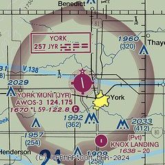
|
| Airport distance calculator |
|---|
|
|
| Sunrise and sunset |
|---|
|
Times for 23-May-2025
| | Local
(UTC-5) | | Zulu
(UTC) |
|---|
| Morning civil twilight | | 05:35 | | 10:35 |
| Sunrise | | 06:07 | | 11:07 |
| Sunset | | 20:47 | | 01:47 |
| Evening civil twilight | | 21:19 | | 02:19 |
|
| Current date and time |
|---|
| Zulu (UTC) | 23-May-2025 18:42:56 |
|---|
| Local (UTC-5) | 23-May-2025 13:42:56 |
|---|
|
| METAR |
|---|
| KJYR | 231815Z AUTO 13006G11KT 5SM -RA BR FEW033 SCT044 BKN070 12/11 A3009 RMK AO2 LTG DSNT SW
|
KAUH
17nm W | 231815Z AUTO 15011KT 7SM +RA SCT065 SCT080 OVC090 13/10 A3009 RMK AO2 LTG DSNT SE P0003 T01260104
|
|
| TAF |
|---|
KGRI
32nm W | 231727Z 2318/2418 11013KT P6SM SCT025 OVC060 TEMPO 2318/2319 -SHRA FM240000 09009KT P6SM OVC025 FM240900 07007KT P6SM VCSH OVC020 FM241600 08012KT P6SM OVC030
|
KLNK
39nm E | 231724Z 2318/2418 12011KT P6SM -SHRA BKN080 FM240000 09009KT P6SM OVC040
|
|
| NOTAMs |
|---|
NOTAMs are issued by the DoD/FAA and will open in a separate window not controlled by AirNav.
|
|


