FAA INFORMATION EFFECTIVE 16 APRIL 2026
Location
| FAA Identifier: | K24 |
| Lat/Long: | 37-00-34.9000N 085-06-09.9000W
37-00.581667N 085-06.165000W
37.0096944,-85.1027500
(estimated) |
| Elevation: | 1010.3 ft. / 307.9 m (surveyed) |
| Variation: | 04W (2005) |
| From city: | 2 miles NW of JAMESTOWN, KY |
| Time zone: | UTC -5 (UTC -6 during Standard Time) |
| Zip code: | 42629 |
Airport Operations
| Airport use: | Open to the public |
| Activation date: | 01/1994 |
| Control tower: | no |
| ARTCC: | INDIANAPOLIS CENTER |
| FSS: | LOUISVILLE FLIGHT SERVICE STATION |
| NOTAMs facility: | LOU (NOTAM-D service available) |
| Attendance: | 0900-1700 |
| Wind indicator: | lighted |
| Segmented circle: | yes |
| Lights: | ACTVT REIL RWY 17 & 35; PAPI RWY 17 & 35; MIRL RWY 17/35 - CTAF. |
| Beacon: | white-green (lighted land airport)
Operates sunset to sunrise. |
Airport Communications
| CTAF/UNICOM: | 123.0 |
| WX AWOS-3P: | 119.6 (270-343-5556) |
| WX AWOS-3PT at EKQ (15 nm SE): | 118.825 (606-348-0862) |
- APCH/DEP SVC PRVDD BY INDIANAPOLIS ARTCC ON FREQS 124.625/371.925 (NEW HOPE RCAG).
Nearby radio navigation aids
| VOR radial/distance | | VOR name | | Freq | | Var |
|---|
| LVTr009/25.7 | | LIVINGSTON VOR/DME | | 114.35 | | 02W |
| NDB name | | Hdg/Dist | | Freq | | Var | | ID |
|---|
| GOODALL | | 208/37.7 | | 311 | | 03W | | DVK | -.. ...- -.- |
Airport Services
| Fuel available: | 100LL JET-A+
100LL:AVBL H24 WITH CREDIT CARD. |
| Parking: | tiedowns |
Runway Information
Runway 17/35
| Dimensions: | 5010 x 78 ft. / 1527 x 24 m |
| Surface: | asphalt, in good condition |
| Weight bearing capacity: | | PCN 15 /F/C/X/T | | Single wheel: | 41.0 | | Double wheel: | 59.5 |
|
| Runway edge lights: | medium intensity |
| RUNWAY 17 | | RUNWAY 35 |
| Latitude: | 37-00.993205N | | 37-00.170452N |
| Longitude: | 085-06.205805W | | 085-06.122453W |
| Elevation: | 1010.3 ft. | | 958.3 ft. |
| Traffic pattern: | left | | left |
| Runway heading: | 179 magnetic, 175 true | | 359 magnetic, 355 true |
| Markings: | nonprecision, in fair condition | | nonprecision, in fair condition |
| Visual slope indicator: | 4-light PAPI on left (3.00 degrees glide path) | | 4-light PAPI on left (3.00 degrees glide path) |
| Runway end identifier lights: | yes | | yes |
| Touchdown point: | yes, no lights | | yes, no lights |
| Obstructions: | 118 ft. trees, 3883 ft. from runway, 69 ft. left of centerline, 31:1 slope to clear | | 60 ft. trees, 1801 ft. from runway, 457 ft. right of centerline, 26:1 slope to clear |
Airport Ownership and Management from official FAA records
| Ownership: | Publicly-owned |
| Owner: | RUSSELL COUNTY AIRPORT BOARD
628 C SMITH ROAD
RUSSELL SPRINGS, KY 42629
Phone 270-585-1935 |
| Manager: | BRAXTON SMITH
628 C SMITH ROAD
RUSSELL SPRINGS, KY 42629
Phone 270-566-6010 |
Additional Remarks
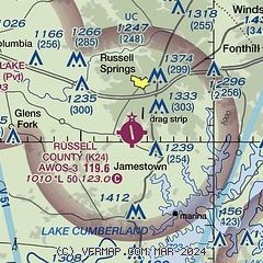
| - | CTN: DRAG STRIP 1 MI NE MAY BE MISTAKEN FOR RWY. |
| - | FOR CD CTC INDIANAPOLIS ARTCC AT 317-247-2411. |
Instrument Procedures
NOTE: All procedures below are presented as PDF files. If you need a reader for these files, you should download the free Adobe Reader.NOT FOR NAVIGATION. Please procure official charts for flight.
FAA instrument procedures published for use from 16 April 2026 at 0901Z to 14 May 2026 at 0900Z.
IAPs - Instrument Approach Procedures |
|---|
| RNAV (GPS) RWY 17 **CHANGED** | |
download (260KB) |
| RNAV (GPS) RWY 35 **CHANGED** | |
download (296KB) |
| NOTE: Special Take-Off Minimums/Departure Procedures apply | |
download (126KB) |
Other nearby airports with instrument procedures:
KEKQ - Wayne County Airport (15 nm SE)
KAAS - Taylor County Airport (23 nm NW)
KSME - Lake Cumberland Regional Airport (23 nm E)
KTZV - Tompkinsville/Monroe County Airport (31 nm SW)
8A3 - Livingston Municipal Airport (37 nm S)
|
|

Road maps at:
MapQuest
Bing
Google
| Aerial photo |
|---|
WARNING: Photo may not be current or correct

Do you have a better or more recent aerial photo of Russell County Airport that you would like to share? If so, please send us your photo.
|
| Sectional chart |
|---|
|
| Airport distance calculator |
|---|
|
|
| Sunrise and sunset |
|---|
|
Times for 09-May-2026
| | Local
(UTC-5) | | Zulu
(UTC) |
|---|
| Morning civil twilight | | 05:10 | | 10:10 |
| Sunrise | | 05:39 | | 10:39 |
| Sunset | | 19:35 | | 00:35 |
| Evening civil twilight | | 20:04 | | 01:04 |
|
| Current date and time |
|---|
| Zulu (UTC) | 09-May-2026 12:00:45 |
|---|
| Local (UTC-5) | 09-May-2026 07:00:45 |
|---|
|
| METAR |
|---|
KEKQ
15nm SE | 091056Z AUTO 17006KT 10SM CLR 13/09 A2986 RMK AO2 SLP104 T01280094 PNO $
|
KAAS
23nm NW | 091135Z AUTO 20006KT 10SM SCT045 SCT065 BKN090 13/09 A2986 RMK AO1
|
KSME
23nm E | 091135Z AUTO 18005KT 10SM FEW110 13/11 A2982 RMK AO2
|
|
| TAF |
|---|
KSME
23nm E | 090535Z 0906/1006 VRB03KT P6SM BKN150 FM091400 25008KT P6SM FEW070 FM100100 00000KT P6SM FEW250
|
|
| NOTAMs |
|---|
NOTAMs are issued by the DoD/FAA and will open in a separate window not controlled by AirNav.
|
|

