FAA INFORMATION EFFECTIVE 14 MAY 2026
Location
| FAA Identifier: | K44 |
| Lat/Long: | 36-47-52.6146N 100-31-36.8895W
36-47.876910N 100-31.614825W
36.7979485,-100.5269137
(estimated) |
| Elevation: | 2491 ft. / 759.3 m (surveyed) |
| Variation: | 09E (1985) |
| From city: | 1 mile SW of BEAVER, OK |
| Time zone: | UTC -5 (UTC -6 during Standard Time) |
| Zip code: | 73932 |
Airport Operations
| Airport use: | Open to the public |
| Activation date: | 12/1946 |
| Control tower: | no |
| ARTCC: | KANSAS CITY CENTER |
| FSS: | MC ALESTER FLIGHT SERVICE STATION |
| NOTAMs facility: | MLC (NOTAM-D service available) |
| Attendance: | UNATNDD |
| Wind indicator: | yes |
| Segmented circle: | yes |
| Lights: | ACTVT MIRL RY 17/35, REIL RYS 17 & 35 - CTAF. |
| Beacon: | white-green (lighted land airport)
Operates sunset to sunrise. |
Airport Communications
Airport Services
| Parking: | tiedowns |
| Airframe service: | NONE |
| Powerplant service: | NONE |
| Bottled oxygen: | NONE |
| Bulk oxygen: | NONE |
Runway Information
Runway 17/35
| Dimensions: | 4050 x 60 ft. / 1234 x 18 m |
| Surface: | asphalt, in fair condition |
| Weight bearing capacity: | |
| Runway edge lights: | medium intensity |
| RUNWAY 17 | | RUNWAY 35 |
| Latitude: | 36-48.179667N | | 36-47.512500N |
| Longitude: | 100-31.572000W | | 100-31.555833W |
| Elevation: | 2470.0 ft. | | 2467.0 ft. |
| Traffic pattern: | left | | left |
| Runway heading: | 170 magnetic, 179 true | | 350 magnetic, 359 true |
| Markings: | basic, in good condition | | basic, in good condition |
| Runway end identifier lights: | yes | | yes |
| Obstructions: | 30 ft. pline, 660 ft. from runway, 100 ft. left and right of centerline, 15:1 slope to clear | | 28 ft. trees, 515 ft. from runway, 11:1 slope to clear |
Runway 4/22
| Dimensions: | 2000 x 130 ft. / 610 x 40 m |
| Surface: | turf, in good condition |
| RUNWAY 4 | | RUNWAY 22 |
| Latitude: | 36-47.823500N | | 36-48.055167N |
| Longitude: | 100-31.863500W | | 100-31.572333W |
| Elevation: | 2486.0 ft. | | 2456.0 ft. |
| Traffic pattern: | left | | left |
| Runway heading: | 036 magnetic, 045 true | | 216 magnetic, 225 true |
| Obstructions: | 10 ft. road, 25 ft. from runway, 2:1 slope to clear | | none |
Airport Ownership and Management from official FAA records
| Ownership: | Publicly-owned |
| Owner: | CITY OF BEAVER
30 W. 2ND ST.
BEAVER, OK 73932
Phone 580-625-3331 |
| Manager: | DAVE DREW
PO BOX 698
BEAVER, OK 73932
Phone 580-625-3331
CITY MANAGER. |
Additional Remarks
| - | RWY 04/22 SOFT WHEN WET. |
| - | FOR CD CTC KANSAS CITY ARTCC AT 913-254-8508. |
Instrument Procedures
There are no published instrument procedures at K44.
Some nearby airports with instrument procedures:
KLBL - Liberal Mid-America Regional Airport (25 nm NW)
KPYX - Perryton Ochiltree County Airport (26 nm SW)
KMEJ - Meade Municipal Airport (30 nm N)
KBFK - Buffalo Municipal Airport (44 nm E)
KHQG - Hugoton Municipal Airport (46 nm NW)
|
|

Road maps at:
MapQuest
Bing
Google
| Aerial photo |
|---|
WARNING: Photo may not be current or correct
 Taken in August 2007
on final for runway 35
Taken in August 2007
on final for runway 35
Do you have a better or more recent aerial photo of Beaver Municipal Airport that you would like to share? If so, please send us your photo.
|
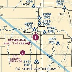
| Sectional chart |
|---|
|
| Airport distance calculator |
|---|
|
|
| Sunrise and sunset |
|---|
|
Times for 26-May-2026
| | Local
(UTC-5) | | Zulu
(UTC) |
|---|
| Morning civil twilight | | 05:58 | | 10:58 |
| Sunrise | | 06:28 | | 11:28 |
| Sunset | | 20:50 | | 01:50 |
| Evening civil twilight | | 21:20 | | 02:20 |
|
| Current date and time |
|---|
| Zulu (UTC) | 26-May-2026 23:30:57 |
|---|
| Local (UTC-5) | 26-May-2026 18:30:57 |
|---|
|
| METAR |
|---|
KPYX
23nm SW | 262315Z AUTO 17020KT 10SM CLR 26/13 A2984 RMK AO2 T02600134
|
KLBL
25nm NW | 262256Z AUTO 15015G22KT 10SM 28/12 A2983 RMK AO2 LTG DSNT SW SLP074 T02780117 $
|
|
| TAF |
|---|
KLBL
25nm NW | 261720Z 2618/2718 16016KT P6SM BKN040 BKN060 FM270800 13005KT P6SM VCSH BKN030 FM271500 12008KT 4SM SHRA BR OVC007
|
|
| NOTAMs |
|---|
NOTAMs are issued by the DoD/FAA and will open in a separate window not controlled by AirNav.
|
|

