FAA INFORMATION EFFECTIVE 25 DECEMBER 2025
Location
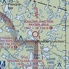
| FAA Identifier: | BDJ |
| Lat/Long: | 46-08-12.7165N 089-38-51.3990W
46-08.211942N 089-38.856650W
46.1368657,-89.6476108
(estimated) |
| Elevation: | 1662 ft. / 507 m (estimated) |
| Variation: | 01W (1985) |
| From city: | 2 miles N of BOULDER JUNCTION, WI |
| Time zone: | UTC -6 (UTC -5 during Daylight Saving Time) |
| Zip code: | 54512 |
Airport Operations
| Airport use: | Open to the public |
| Activation date: | 10/1947 |
| Control tower: | no |
| ARTCC: | MINNEAPOLIS CENTER |
| FSS: | GREEN BAY FLIGHT SERVICE STATION |
| NOTAMs facility: | GRB (NOTAM-D service available) |
| Attendance: | MAY-NOV/UNATNDD/, DEC-APR/CLSD/ |
| Wind indicator: | yes |
| Segmented circle: | no |
Airport Communications
| CTAF: | 122.9 |
| WX AWOS-3PT at D25 (10 nm W): | 118.175 (715-543-2004) |
| WX AWOS-3 at ARV (13 nm S): | 121.125 (715-356-2417) |
| WX AWOS-3 at LNL (18 nm E): | 119.525 (715-547-6313) |
Nearby radio navigation aids
| VOR radial/distance | | VOR name | | Freq | | Var |
|---|
| IWDr139/30.9 | | IRONWOOD VOR/DME | | 108.80 | | 01E |
| RHIr343/31.2 | | RHINELANDER VOR/DME | | 115.05 | | 02E |
Airport Services
| Parking: | tiedowns |
| Airframe service: | NONE |
| Powerplant service: | NONE |
| Bottled oxygen: | NONE |
| Bulk oxygen: | NONE |
Runway Information
Runway 5/23
| Dimensions: | 3821 x 165 ft. / 1165 x 50 m |
| Surface: | turf, in fair condition |
| Runway edge markings: | MKD WITH YELLOW A-FRAME. |
| RUNWAY 5 | | RUNWAY 23 |
| Latitude: | 46-07.951667N | | 46-08.375667N |
| Longitude: | 089-39.310333W | | 089-38.642667W |
| Elevation: | 1649.0 ft. | | 1661.0 ft. |
| Traffic pattern: | left | | left |
| Runway heading: | 049 magnetic, 048 true | | 229 magnetic, 228 true |
| Displaced threshold: | 800 ft.
MKD WITH YELLOW A-FRAMES. | | 310 ft.
MKD WITH YELLOW A-FRAMES. |
| Markings: | none | | none |
| Runway end identifier lights: | no | | no |
| Obstructions: | 15 ft. road, 20 ft. from runway, 125 ft. left of centerline, 1:1 slope to clear
APCH RATIO 20:1 TO DSPLCD THR. | | 50 ft. trees, 115 ft. left of centerline
APCH RATIO 6:1 TO DSPLCD THR; 50 FT TREES 310 FT FM DSPLCD THR, 115 FT L. |
Runway 16/34
| Dimensions: | 3214 x 160 ft. / 980 x 49 m |
| Surface: | turf, in fair condition |
| Runway edge markings: | MKD WITH YELLOW A-FRAME. |
| RUNWAY 16 | | RUNWAY 34 |
| Latitude: | 46-08.520000N | | 46-08.018667N |
| Longitude: | 089-38.835000W | | 089-38.593333W |
| Elevation: | 1661.0 ft. | | 1656.0 ft. |
| Traffic pattern: | left | | left |
| Runway heading: | 162 magnetic, 161 true | | 342 magnetic, 341 true |
| Displaced threshold: | 274 ft.
MKD WITH YELLOW A-FRAMES. | | 207 ft.
MKD WITH YELLOW A-FRAMES. |
| Markings: | none | | none |
| Runway end identifier lights: | no | | no |
| Obstructions: | 15 ft. road, 100 ft. right of centerline
APCH RATIO 18:1 TO DSPLCD THR; 15 FT ROAD 270 FT FM DSPCLD THR, 100 FT R. | | 50 ft. trees, 100 ft. left and right of centerline
APCH RATIO 3:1 TO DSPLCD THR; 65 FT TREES 210 FT FM DSPLCD THR, 1025 FT L/R. |
Airport Ownership and Management from official FAA records
| Ownership: | Publicly-owned |
| Owner: | TOWN OF BOULDER JUNCTION
PO BOX 616
BOULDER JUNCTION, WI 54512
Phone 715-385-2220 |
| Manager: | JOE SALAJA
PO BOX 642
BOULDER JUNCTION, WI 54512
Phone 414-333-5521 |
Additional Remarks
| - | ARPT NOT PLOWED WINTER MONTHS. |
| - | FOR CD CTC MINNEAPOLIS ARTCC AT 651-463-5588. |
| - | WILDLIFE ON & INVOF ARPT. |
Instrument Procedures
There are no published instrument procedures at KBDJ.
Some nearby airports with instrument procedures:
D25 - Manitowish Waters Airport (10 nm W)
KARV - Lakeland Airport/Noble F. Lee Memorial Field (13 nm S)
KLNL - Kings Land O' Lakes Airport (18 nm E)
KEGV - Eagle River Union Airport (20 nm SE)
KIWD - Gogebic/Iron County Airport (31 nm NW)
|
|

Road maps at:
MapQuest
Bing
Google
| Aerial photo |
|---|
WARNING: Photo may not be current or correct

Do you have a better or more recent aerial photo of Boulder Junction Payzer Airport that you would like to share? If so, please send us your photo.
|
| Sectional chart |
|---|
|
| Airport distance calculator |
|---|
|
|
| Sunrise and sunset |
|---|
|
Times for 12-Jan-2026
| | Local
(UTC-6) | | Zulu
(UTC) |
|---|
| Morning civil twilight | | 07:06 | | 13:06 |
| Sunrise | | 07:40 | | 13:40 |
| Sunset | | 16:34 | | 22:34 |
| Evening civil twilight | | 17:08 | | 23:08 |
|
| Current date and time |
|---|
| Zulu (UTC) | 13-Jan-2026 01:37:15 |
|---|
| Local (UTC-6) | 12-Jan-2026 19:37:15 |
|---|
|
| METAR |
|---|
KD25
10nm W | 130115Z AUTO 17003KT 10SM CLR M05/M05 A2984 RMK AO2 T10461046
|
KARV
14nm S | 130115Z AUTO 00000KT 10SM CLR M03/M04 A2985 RMK AO2 T10341040
|
KLNL
18nm E | 130115Z AUTO 00000KT 10SM CLR M02/M02 A2986 RMK AO2 T10221022
|
|
| TAF |
|---|
KIWD
30nm NW | 121739Z 1218/1318 25009KT P6SM FEW210 FM130800 21008KT P6SM OVC045 TEMPO 1308/1312 3SM -SHRASN OVC010 FM131200 24009KT 2SM -SHRASN OVC008 FM131600 26011G20KT 4SM -SHRA BKN007
|
KRHI
31nm S | 121743Z 1218/1318 26010G17KT P6SM SCT200 FM122200 24005KT P6SM BKN200 FM130800 22006KT P6SM -FZRAPL SCT025 OVC050 FM131000 23007G15KT 4SM -PLSN BKN015 OVC022 FM131200 24008G17KT 2SM -PLSN OVC008 FM131500 27009G19KT 4SM -FZDZ BR OVC008 WS020/30035KT
|
|
| NOTAMs |
|---|
NOTAMs are issued by the DoD/FAA and will open in a separate window not controlled by AirNav.
|
|

