FAA INFORMATION EFFECTIVE 14 MAY 2026
Location
| FAA Identifier: | CEK |
| Lat/Long: | 40-37-06.1562N 096-55-32.5513W
40-37.102603N 096-55.542522W
40.6183767,-96.9257087
(estimated) |
| Elevation: | 1499.5 ft. / 457.0 m (surveyed) |
| Variation: | 05E (2000) |
| From city: | 2 miles E of CRETE, NE |
| Time zone: | UTC -5 (UTC -6 during Standard Time) |
| Zip code: | 68333 |
Airport Operations
| Airport use: | Open to the public |
| Activation date: | 12/1949 |
| Control tower: | no |
| ARTCC: | MINNEAPOLIS CENTER |
| FSS: | COLUMBUS FLIGHT SERVICE STATION |
| NOTAMs facility: | OLU (NOTAM-D service available) |
| Attendance: | 0800-1800 |
| Wind indicator: | lighted |
| Segmented circle: | yes |
| Lights: | SS-SR |
| Beacon: | white-green (lighted land airport)
Operates sunset to sunrise. |
Airport Communications
| CTAF/UNICOM: | 122.8 |
| OMAHA APPROACH: | 124.0 |
| OMAHA DEPARTURE: | 124.0 |
| WX ASOS at LNK (16 nm NE): | PHONE 402-417-0560 |
Nearby radio navigation aids
| VOR radial/distance | | VOR name | | Freq | | Var |
|---|
| LNKr195/20.1 | | LINCOLN VORTAC | | 116.10 | | 09E |
| BIEr331/(20.6) | | BEATRICE VOR | | 110.60 | | 07E |
| NDB name | | Hdg/Dist | | Freq | | Var | | ID |
|---|
| FAIRBURY | | 016/28.7 | | 293 | | 06E | | FBY | ..-. -... -.-- |
| BEKLOF | | 084/29.3 | | 392 | | 03E | | FMZ | ..-. -- --.. |
| YORK | | 112/35.6 | | 257 | | 06E | | JYR | .--- -.-- .-. |
Airport Services
| Fuel available: | 100LL JET-A
A:FOR SVC AFT HRS 402-314-0887.
100LL:FOR SVC AFT HRS 402-314-0887. |
| Parking: | hangars and tiedowns |
| Airframe service: | MAJOR |
| Powerplant service: | MAJOR |
| Bottled oxygen: | HIGH/LOW |
| Bulk oxygen: | NONE |
Runway Information
Runway 17/35
| Dimensions: | 4201 x 75 ft. / 1280 x 23 m |
| Surface: | concrete, in fair condition |
| Weight bearing capacity: | | Single wheel: | 28.0 | | Double wheel: | 48.0 |
|
| Runway edge lights: | high intensity |
| RUNWAY 17 | | RUNWAY 35 |
| Latitude: | 40-37.420288N | | 40-36.728415N |
| Longitude: | 096-55.490532W | | 096-55.495272W |
| Elevation: | 1499.1 ft. | | 1478.8 ft. |
| Traffic pattern: | left | | left |
| Runway heading: | 175 magnetic, 180 true | | 355 magnetic, 000 true |
| Markings: | nonprecision, in good condition | | nonprecision, in good condition |
| Visual slope indicator: | 2-light PAPI on left (3.00 degrees glide path)
RY 17 PAPI UNUSBL BYD 8 DEGS LEFT OF CNTRLN. | | 2-light PAPI on left (3.00 degrees glide path) |
| Runway end identifier lights: | yes | | yes |
| Touchdown point: | yes, no lights | | yes, no lights |
Runway 13/31
| Dimensions: | 3370 x 150 ft. / 1027 x 46 m |
| Surface: | turf, in fair condition |
| RUNWAY 13 | | RUNWAY 31 |
| Latitude: | 40-37.335182N | | 40-36.940460N |
| Longitude: | 096-55.860340W | | 096-55.348417W |
| Elevation: | 1491.4 ft. | | 1495.8 ft. |
| Traffic pattern: | left | | left |
| Runway heading: | 130 magnetic, 135 true | | 310 magnetic, 315 true |
| Touchdown point: | yes, no lights | | yes, no lights |
Airport Ownership and Management from official FAA records
| Ownership: | Publicly-owned |
| Owner: | CITY OF CRETE
PO BOX 86
CRETE, NE 68333-0086
Phone (402) 826-7673
CITY OF CRETE, NEBRASKA |
| Manager: | JUSTIN HAACK
2429 COUNTY ROAD F, CRETE AVIATION
CRETE, NE 68333-0014
Phone 402-826-4408 |
Additional Remarks
| - | FOR CD CTC OMAHA APCH AT 402-682-4395. |
Instrument Procedures
NOTE: All procedures below are presented as PDF files. If you need a reader for these files, you should download the free Adobe Reader.NOT FOR NAVIGATION. Please procure official charts for flight.
FAA instrument procedures published for use from 14 May 2026 at 0901Z to 11 June 2026 at 0900Z.
IAPs - Instrument Approach Procedures |
|---|
| RNAV (GPS) RWY 17 | |
download (180KB) |
| RNAV (GPS) RWY 35 | |
download (192KB) |
| VOR/DME RWY 17 | |
download (186KB) |
| VOR/DME RWY 35 | |
download (161KB) |
| NOTE: Special Take-Off Minimums/Departure Procedures apply | |
download (147KB) |
Other nearby airports with instrument procedures:
KLNK - Lincoln Airport (16 nm NE)
KSWT - Seward Municipal Airport (17 nm NW)
KBIE - Beatrice Municipal Airport (21 nm S)
KFBY - Fairbury Municipal Airport (28 nm SW)
KFMZ - Fairmont State Airport (30 nm W)
|
|

Road maps at:
MapQuest
Bing
Google
| Aerial photo |
|---|
WARNING: Photo may not be current or correct
 Photo taken 17-Apr-2010
looking west from approximately 4000
Photo taken 17-Apr-2010
looking west from approximately 4000
Do you have a better or more recent aerial photo of Crete Municipal Airport that you would like to share? If so, please send us your photo.
|
| Sectional chart |
|---|
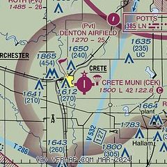
|
| Airport distance calculator |
|---|
|
|
| Sunrise and sunset |
|---|
|
Times for 09-Jun-2026
| | Local
(UTC-5) | | Zulu
(UTC) |
|---|
| Morning civil twilight | | 05:25 | | 10:25 |
| Sunrise | | 05:58 | | 10:58 |
| Sunset | | 20:56 | | 01:56 |
| Evening civil twilight | | 21:29 | | 02:29 |
|
| Current date and time |
|---|
| Zulu (UTC) | 10-Jun-2026 01:31:18 |
|---|
| Local (UTC-5) | 09-Jun-2026 20:31:18 |
|---|
|
| METAR |
|---|
KLNK
15nm NE | 100054Z 17015KT 10SM CLR 31/24 A2969 RMK AO2 PRESRR SLP041 T03060239
|
KBIE
22nm S | 100115Z AUTO 18014KT 10SM CLR 31/23 A2973 RMK AO2 T03120227
|
|
| TAF |
|---|
KLNK
15nm NE | 091917Z 0919/1018 18015G25KT P6SM BKN040 FM100300 18017G28KT P6SM FEW250 WS015/22048KT FM101000 19015G26KT P6SM SCT150 FM101600 23015G24KT P6SM FEW160 BKN250
|
|
| NOTAMs |
|---|
NOTAMs are issued by the DoD/FAA and will open in a separate window not controlled by AirNav.
|
|

