FAA INFORMATION EFFECTIVE 15 MAY 2025
Location
| FAA Identifier: | CNM |
| Lat/Long: | 32-20-14.8000N 104-15-48.1000W
32-20.246667N 104-15.801667W
32.3374444,-104.2633611
(estimated) |
| Elevation: | 3294.6 ft. / 1004.2 m (surveyed) |
| Variation: | 10E (1985) |
| From city: | 5 miles SW of CARLSBAD, NM |
| Time zone: | UTC -6 (UTC -7 during Standard Time) |
| Zip code: | 88220 |
Airport Operations
| Airport use: | Open to the public |
| Activation date: | 04/1941 |
| Control tower: | no |
| ARTCC: | ALBUQUERQUE CENTER |
| FSS: | ALBUQUERQUE FLIGHT SERVICE STATION |
| NOTAMs facility: | CNM (NOTAM-D service available) |
| Attendance: | MON-FRI 0600-2000, ALL SAT-SUN 0700-1700
SFC COND UNMTD MON-FRI 2200-1200 UTC (1500-0500 LOCAL) AND SAT-SUN 2030-1200 UTC (1330-0500 LOCAL). |
| Wind indicator: | lighted |
| Segmented circle: | yes |
| Lights: | ACTVT MALSR RWY 03; MIRL RWY 03/21, 08/26 & 14R/32L - CTAF. MALSR RWY 03 & MIRL RWY 03/21, 08/26, 14R/32L PRESET LOW INTST; INCR INTST - CTAF. |
| Beacon: | white-green (lighted land airport)
Operates sunset to sunrise. |
| Fire and rescue: | ARFF index A |
| Airline operations: | ACR OPS MORE THAN 30 PAX SEATS 24 HR PPR - AMGR. |
Airport Communications
| CTAF/UNICOM: | 123.0 |
| WX ASOS: | 118.375 (575-887-6858) |
- APCH/DEP SVC PRVDD BY ALBUQUERQUE ARTCC (ABQ) ON FREQS 135.875/292.15 (CARLSBAD RCAG).
Nearby radio navigation aids
| VOR radial/distance | | VOR name | | Freq | | Var |
|---|
| CNMr327/5.2 | | CARLSBAD VORTAC | | 116.30 | | 12E |
| NDB name | | Hdg/Dist | | Freq | | Var | | ID |
|---|
| CARLZ | | 032/5.7 | | 402 | | 10E | | CV | -.-. ...- |
Airport Services
| Fuel available: | 100LL JET-A1+
100LL:FUEL AFT HR & WKEND - 575-887-1500. |
| Parking: | hangars and tiedowns |
Runway Information
Runway 3/21
| Dimensions: | 7854 x 150 ft. / 2394 x 46 m |
| Surface: | asphalt/porous friction courses, in good condition |
| Weight bearing capacity: | | PCN 20 /F/D/X/T | | Single wheel: | 62.0 | | Double wheel: | 88.0 | | Double tandem: | 140.0 |
|
| Runway edge lights: | medium intensity |
| RUNWAY 3 | | RUNWAY 21 |
| Latitude: | 32-19.358965N | | 32-20.288232N |
| Longitude: | 104-16.455737W | | 104-15.393303W |
| Elevation: | 3294.5 ft. | | 3247.4 ft. |
| Traffic pattern: | left | | left |
| Runway heading: | 034 magnetic, 044 true | | 214 magnetic, 224 true |
| Declared distances: | TORA:7854 TODA:7854 ASDA:7504 LDA:7504 | | TORA:7854 TODA:7854 ASDA:7854 LDA:7854 |
| Markings: | precision, in poor condition | | nonprecision, in poor condition |
| Visual slope indicator: | | | 4-box VASI on left (3.00 degrees glide path) |
| Approach lights: | MALSR: 1,400 foot medium intensity approach lighting system with runway alignment indicator lights | | |
| Runway end identifier lights: | no | | |
| Touchdown point: | yes, no lights | | yes, no lights |
| Instrument approach: | ILS | | |
| Obstructions: | 24 ft. road, 1080 ft. from runway, 623 ft. left of centerline, 36:1 slope to clear | | 14 ft. road, 388 ft. from runway, 514 ft. left of centerline, 13:1 slope to clear |
Runway 14R/32L
| Dimensions: | 5837 x 100 ft. / 1779 x 30 m |
| Surface: | asphalt, in good condition |
| Weight bearing capacity: | | PCN 9 /F/D/X/T | | Single wheel: | 30.0 | | Double wheel: | 45.0 |
|
| Runway edge lights: | medium intensity |
| RUNWAY 14R | | RUNWAY 32L |
| Latitude: | 32-20.573478N | | 32-19.708142N |
| Longitude: | 104-16.251595W | | 104-15.755097W |
| Elevation: | 3269.3 ft. | | 3266.8 ft. |
| Traffic pattern: | right | | left |
| Runway heading: | 144 magnetic, 154 true | | 324 magnetic, 334 true |
| Displaced threshold: | no | | 385 ft. |
| Declared distances: | TORA:5837 TODA:5837 ASDA:5837 LDA:5837 | | TORA:5837 TODA:5837 ASDA:5837 LDA:5452 |
| Markings: | nonprecision, in good condition | | nonprecision, in good condition |
| Visual slope indicator: | 4-light PAPI on left (3.00 degrees glide path) | | 4-light PAPI on left (3.00 degrees glide path) |
| Touchdown point: | yes, no lights | | yes, no lights |
| Obstructions: | 7 ft. road, 300 ft. from runway, 150 ft. left of centerline, 14:1 slope to clear | | 15 ft. road, 672 ft. from runway, 318 ft. right of centerline, 31:1 slope to clear
APCH SLOPE 50:1 FM DTHR. |
Runway 8/26
| Dimensions: | 5334 x 75 ft. / 1626 x 23 m |
| Surface: | asphalt, in good condition |
| Weight bearing capacity: | | PCN 9 /F/C/Y/T | | Single wheel: | 19.0 |
|
| Runway edge lights: | medium intensity |
| RUNWAY 8 | | RUNWAY 26 |
| Latitude: | 32-20.537733N | | 32-20.537417N |
| Longitude: | 104-16.243525W | | 104-15.207562W |
| Elevation: | 3269.8 ft. | | 3238.8 ft. |
| Traffic pattern: | left | | left |
| Runway heading: | 080 magnetic, 090 true | | 260 magnetic, 270 true |
| Declared distances: | TORA:5334 TODA:5334 ASDA:5334 LDA:5334 | | TORA:5334 TODA:5334 ASDA:5334 LDA:5334 |
| Markings: | basic, in good condition | | basic, in good condition |
| Touchdown point: | yes, no lights | | yes, no lights |
| Obstructions: | 15 ft. road, 310 ft. from runway, 7:1 slope to clear | | 4 ft. fence, 200 ft. from runway, 125 ft. right of centerline |
Runway 14L/32R
| Dimensions: | 4616 x 150 ft. / 1407 x 46 m |
| Surface: | asphalt, in fair condition |
| Weight bearing capacity: | | PCN 4 /F/D/Y/T | | Single wheel: | 8.0 | | Double wheel: | 12.5 |
|
| Operational restrictions: | ACR OPS NA. |
| RUNWAY 14L | | RUNWAY 32R |
| Latitude: | 32-21.111197N | | 32-20.414763N |
| Longitude: | 104-15.604910W | | 104-15.243073W |
| Elevation: | 3240.6 ft. | | 3241.3 ft. |
| Traffic pattern: | left | | right |
| Runway heading: | 146 magnetic, 156 true | | 326 magnetic, 336 true |
| Displaced threshold: | no | | 615 ft. |
| Declared distances: | TORA:4615 TODA:4615 ASDA:4615 LDA:4615 | | TORA:4615 TODA:4615 ASDA:4615 LDA:3999 |
| Markings: | basic, in good condition | | basic, in good condition |
| Touchdown point: | yes, no lights | | yes, no lights |
| Obstructions: | none | | 15 ft. road, 230 ft. from runway, 150 ft. right of centerline
APCH SLOPE 38:1 FM DTHR. |
Airport Ownership and Management from official FAA records
| Ownership: | Publicly-owned |
| Owner: | CITY OF CARLSBAD
101 NORTH HALAGUENO ST
CARLSBAD, NM 88220
Phone 575-887-1191 |
| Manager: | ROBERT ESPINOZA
101 NORTH HALAGUENO ST
CARLSBAD, NM 88220
Phone 575-887-3060 |
Additional Remarks
| - | OIL DERRICKS INVOF ARPT. |
| - | FOR CD IF UNA TO CTC ON FSS FREQ, CTC ALBUQUERQUE ARTCC AT 505-856-4561. |
Instrument Procedures
NOTE: All procedures below are presented as PDF files. If you need a reader for these files, you should download the free Adobe Reader.NOT FOR NAVIGATION. Please procure official charts for flight.
FAA instrument procedures published for use from 15 May 2025 at 0901Z to 13 June 2025 at 0900z.
IAPs - Instrument Approach Procedures |
|---|
| ILS RWY 03 | |
download (216KB) |
| RNAV (GPS) RWY 03 | |
download (239KB) |
| RNAV (GPS) RWY 14R | |
download (226KB) |
| RNAV (GPS) RWY 21 | |
download (235KB) |
| RNAV (GPS) RWY 32L | |
download (251KB) |
| VOR RWY 32L | |
download (238KB) |
| NOTE: Special Alternate Minimums apply | |
download (36KB) |
| NOTE: Special Take-Off Minimums/Departure Procedures apply | |
download (298KB) |
Other nearby airports with instrument procedures:
KATS - Artesia Municipal Airport (33 nm N)
E06 - Lea County/Zip Franklin Memorial Airport (57 nm NE)
KHOB - Lea County Regional Airport (57 nm E)
KROW - Roswell Air Center Airport (59 nm N)
KINK - Winkler County Airport (64 nm SE)
|
|

Road maps at:
MapQuest
Bing
Google
| Aerial photo |
|---|
WARNING: Photo may not be current or correct
 Photo taken 18-Nov-2005
Do you have a better or more recent aerial photo of Cavern City Air Terminal that you would like to share? If so, please send us your photo.
|
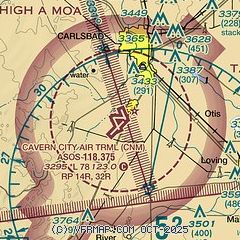
| Sectional chart |
|---|
|
CAUTION: Diagram may not be current

| Airport distance calculator |
|---|
|
|
| Sunrise and sunset |
|---|
|
Times for 19-May-2025
| | Local
(UTC-6) | | Zulu
(UTC) |
|---|
| Morning civil twilight | | 05:30 | | 11:30 |
| Sunrise | | 05:57 | | 11:57 |
| Sunset | | 19:50 | | 01:50 |
| Evening civil twilight | | 20:17 | | 02:17 |
|
| Current date and time |
|---|
| Zulu (UTC) | 19-May-2025 08:13:02 |
|---|
| Local (UTC-6) | 19-May-2025 02:13:02 |
|---|
|
| METAR |
|---|
| KCNM | 190753Z AUTO 25009KT 10SM CLR 22/M07 A2974 RMK AO2 SLP007 T02221072 $
|
|
| TAF |
|---|
| KCNM | 190520Z 1906/2006 27011KT P6SM SKC FM191600 26025G34KT P6SM SKC FM200400 32011KT P6SM SKC
|
|
| NOTAMs |
|---|
NOTAMs are issued by the DoD/FAA and will open in a separate window not controlled by AirNav.
|
|


