FAA INFORMATION EFFECTIVE 14 MAY 2026
Location
| FAA Identifier: | CQX |
| Lat/Long: | 41-41-17.8950N 069-59-22.7470W
41-41.298250N 069-59.379117W
41.6883042,-69.9896519
(estimated) |
| Elevation: | 63.6 ft. / 19.4 m (surveyed) |
| Variation: | 16W (1990) |
| From city: | 2 miles NW of CHATHAM, MA |
| Time zone: | UTC -4 (UTC -5 during Standard Time) |
| Zip code: | 02633 |
Airport Operations
| Airport use: | Open to the public |
| Activation date: | 04/1940 |
| Control tower: | no |
| ARTCC: | BOSTON CENTER |
| FSS: | BRIDGEPORT FLIGHT SERVICE STATION |
| NOTAMs facility: | CQX (NOTAM-D service available) |
| Attendance: | 0800-DUSK |
| Wind indicator: | yes |
| Segmented circle: | yes |
| Lights: | ACTVT MIRL RWY 06/24 - 122.95. |
| Beacon: | white-green (lighted land airport)
Operates sunset to sunrise. |
Airport Communications
| CTAF/UNICOM: | 122.8 |
| WX ASOS: | 135.875 (508-945-5034) |
| BOSTON APPROACH: | 118.2 |
| BOSTON DEPARTURE: | 118.2 |
| CLEARANCE DELIVERY: | 127.3 |
| WX ASOS at HYA (13 nm W): | PHONE 508-862-2601 |
Nearby radio navigation aids
| VOR radial/distance | | VOR name | | Freq | | Var |
|---|
| LFVr190/19.8 | | MARCONI VOR/DME | | 114.70 | | 16W |
| ACKr019/24.4 | | NANTUCKET VOR/DME | | 116.20 | | 15W |
| MVYr073/33.0 | | MARTHAS VINEYARD VOR/DME | | 114.50 | | 15W |
| NDB name | | Hdg/Dist | | Freq | | Var | | ID |
|---|
| NAUSET | | at field | | 279 | | 16W | | CQX | -.-. --.- -..- |
| PROVINCETOWN | | 171/25.1 | | 389 | | 16W | | PVC | .--. ...- -.-. |
Airport Services
| Fuel available: | 100LL JET-A JET-A+ |
| Parking: | hangars and tiedowns |
| Airframe service: | MAJOR |
| Powerplant service: | MINOR |
| Bottled oxygen: | NONE |
| Bulk oxygen: | NONE |
Runway Information
Runway 6/24
| Dimensions: | 3001 x 100 ft. / 915 x 30 m |
| Surface: | asphalt, in good condition |
| Weight bearing capacity: | |
| Runway edge lights: | medium intensity |
| RUNWAY 6 | | RUNWAY 24 |
| Latitude: | 41-41.120298N | | 41-41.476203N |
| Longitude: | 069-59.607685W | | 069-59.150537W |
| Elevation: | 49.0 ft. | | 62.6 ft. |
| Traffic pattern: | left | | left |
| Runway heading: | 060 magnetic, 044 true | | 240 magnetic, 224 true |
| Markings: | basic, in good condition | | basic, in good condition |
| Visual slope indicator: | 2-light PAPI on left (3.50 degrees glide path) | | 2-light PAPI on right (3.50 degrees glide path) |
| Runway end identifier lights: | yes | | yes |
| Touchdown point: | yes, no lights | | yes, no lights |
| Obstructions: | 120 ft. trees, 800 ft. from runway, 150 ft. right of centerline, 5:1 slope to clear | | 232 ft. tank, 3100 ft. from runway, 25 ft. left of centerline, 12:1 slope to clear |
Airport Ownership and Management from official FAA records
| Ownership: | Publicly-owned |
| Owner: | TOWN OF CHATHAM
549 MAIN STREET
CHATHAM, MA 02633
Phone 508-945-5100 |
| Manager: | TIMOTHY HOWARD
CHATHAM MUNICIPAL AIRPORT, GEORGE RYDER ROAD
CHATHAM, MA 02633
Phone 508-945-9000 |
Additional Remarks
| - | CHECK NOTAMS FOR TREE OBS ON APCH AREAS TO RWYS 06 & 24. |
| - | BE AWARE OF HIGH-SPD MIL JET & HVY HEL TFC VCNTY CAPE COD CGAS. |
| - | BIRDS PRIMLY GULLS AND WILDLIFE ON OR INVOF ARPT. |
| - | RCMD MIN ALT OF 2000 FT AGL FM NORTHEAST TO SOUTHEAST OF ARPT OVER NATL SEASHORE . |
| - | WATER LDG AREA CLSD PERMLY. |
| - | NOISE ABATEMENT RWY 6/24: USE FULL RWY & AVOID INTXN DEPS. MINIMIZE OR AVOID TGL OPNS. CLIMB OUT ON RWY HDG TIL 1100 FT OVR WATER THEN PROCD ON CRS. REDUCE PWR AS SOON AS PRACTICAL. |
| - | RWY 6/24, FLY PAT DOWNWIND LEG 1/2 TO 1 MILE OUT FM RWY AS PRACTICABLE. |
| - | AVOID RESIDENTIAL AREAS AS MUCH AS PSBL. |
| - | FOR CD CTC BOSTON APCH AT 603-594-5554. |
Instrument Procedures
NOTE: All procedures below are presented as PDF files. If you need a reader for these files, you should download the free Adobe Reader.NOT FOR NAVIGATION. Please procure official charts for flight.
FAA instrument procedures published for use from 14 May 2026 at 0901Z to 11 June 2026 at 0900Z.
IAPs - Instrument Approach Procedures |
|---|
| RNAV (GPS)-B | |
download (216KB) |
| NDB-A | |
download (210KB) |
| NOTE: Special Alternate Minimums apply | |
download (129KB) |
| NOTE: Special Take-Off Minimums/Departure Procedures apply | |
download (178KB) |
Other nearby airports with instrument procedures:
KHYA - Cape Cod Gateway Airport (13 nm W)
KFMH - Cape Cod Coast Guard Air Station (24 nm W)
KPVC - Provincetown Municipal Airport (25 nm NW)
5B6 - Falmouth Airpark (25 nm W)
KACK - Nantucket Memorial Airport (26 nm S)
|
|

Road maps at:
MapQuest
Bing
Google
| Aerial photo |
|---|
WARNING: Photo may not be current or correct
 Photo by Sal Salvaggio
Taken in the Summer of 2020
looking west.
Photo by Sal Salvaggio
Taken in the Summer of 2020
looking west.
Do you have a better or more recent aerial photo of Chatham Municipal Airport that you would like to share? If so, please send us your photo.
|
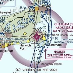
| Sectional chart |
|---|
|
| Airport distance calculator |
|---|
|
|
| Sunrise and sunset |
|---|
|
Times for 16-May-2026
| | Local
(UTC-4) | | Zulu
(UTC) |
|---|
| Morning civil twilight | | 04:48 | | 08:48 |
| Sunrise | | 05:20 | | 09:20 |
| Sunset | | 19:52 | | 23:52 |
| Evening civil twilight | | 20:24 | | 00:24 |
|
| Current date and time |
|---|
| Zulu (UTC) | 16-May-2026 17:57:38 |
|---|
| Local (UTC-4) | 16-May-2026 13:57:38 |
|---|
|
| METAR |
|---|
| KCQX | 161752Z AUTO 22012G22KT 10SM CLR 15/11 A3004 RMK AO2 SLP174 T01500111 10156 20133 58015
|
KHYA
12nm W | 161656Z 20012KT 10SM CLR 16/11 A3003 RMK AO2 SLP169 T01610111 $
|
|
| TAF |
|---|
KHYA
12nm W | 161120Z 1612/1712 24007KT P6SM FEW250 FM161500 22010G17KT P6SM SCT250 FM161900 21013G23KT P6SM FEW250
|
|
| NOTAMs |
|---|
NOTAMs are issued by the DoD/FAA and will open in a separate window not controlled by AirNav.
|
|

