FAA INFORMATION EFFECTIVE 09 JULY 2026
Location
| FAA Identifier: | CZD |
| Lat/Long: | 40-52-10.5330N 100-00-15.3050W
40-52.175550N 100-00.255083W
40.8695925,-100.0042514
(estimated) |
| Elevation: | 2503.2 ft. / 763.0 m (surveyed) |
| Variation: | 07E (2005) |
| From city: | 1 mile NW of COZAD, NE |
| Time zone: | UTC -5 (UTC -6 during Standard Time) |
| Zip code: | 69130 |
Airport Operations
| Airport use: | Open to the public |
| Activation date: | 04/1947 |
| Control tower: | no |
| ARTCC: | DENVER CENTER |
| FSS: | COLUMBUS FLIGHT SERVICE STATION |
| NOTAMs facility: | OLU (NOTAM-D service available) |
| Attendance: | MON-FRI 0800-1700 |
| Wind indicator: | lighted |
| Segmented circle: | yes |
| Lights: | ACTVT PAPI RWY 13 & 31; MIRL RWY 13/31 - CTAF. |
| Beacon: | white-green (lighted land airport)
Operates sunset to sunrise. |
Airport Communications
| CTAF/UNICOM: | 122.8 |
| WX AWOS-3 at LXN (11 nm SE): | 121.025 (308-324-5975) |
- APCH/DEP CTL SVC PRVDD BY DENVER ARTCC (ZDV) ON FREQS 132.7/226.675 (NORTH PLATTE RCAG).
Nearby radio navigation aids
| VOR radial/distance | | VOR name | | Freq | | Var |
|---|
| OZB at field | | COZAD VOR | | 109.00 | | 09E |
| LBFr097/35.3 | | NORTH PLATTE VOR/DME | | 117.40 | | 11E |
| CUZr193/39.5 | | CUSTER COUNTY VOR/DME | | 108.20 | | 08E |
Airport Services
| Fuel available: | 100LL JET-A
100LL:AVBL H24 VIA CREDIT CARD.
A:AVBL H24 VIA CREDIT CARD. |
| Parking: | hangars and tiedowns |
| Airframe service: | NONE |
| Powerplant service: | NONE |
| Bottled oxygen: | NONE |
| Bulk oxygen: | NONE |
Runway Information
Runway 13/31
| Dimensions: | 5000 x 75 ft. / 1524 x 23 m |
| Surface: | concrete, in good condition |
| Weight bearing capacity: | |
| Runway edge lights: | medium intensity |
| RUNWAY 13 | | RUNWAY 31 |
| Latitude: | 40-52.497923N | | 40-51.891682N |
| Longitude: | 100-00.679192W | | 099-59.945202W |
| Elevation: | 2503.2 ft. | | 2497.3 ft. |
| Traffic pattern: | left | | left |
| Runway heading: | 130 magnetic, 137 true | | 310 magnetic, 317 true |
| Markings: | nonprecision, in good condition | | nonprecision, in good condition |
| Visual slope indicator: | 2-light PAPI on left (3.00 degrees glide path) | | 2-light PAPI on left (3.75 degrees glide path) |
| Touchdown point: | yes, no lights | | yes, no lights |
| Obstructions: | none
GRAIN ELEVATOR. | | 167 ft. other, lighted, 3560 ft. from runway, 330 ft. right of centerline, 20:1 slope to clear
CLNC SLP 26:1 ALSO DUE TO ROAD 631 FT OUT 16 FT ABV 0B. |
Runway 18/36
| Dimensions: | 3000 x 300 ft. / 914 x 91 m |
| Surface: | turf, in good condition |
| Runway edge markings: | MKD WITH YELLOW CONES. |
| RUNWAY 18 | | RUNWAY 36 |
| Latitude: | 40-52.386237N | | 40-51.900622N |
| Longitude: | 100-00.100275W | | 100-00.219575W |
| Elevation: | 2499.5 ft. | | 2497.2 ft. |
| Traffic pattern: | left | | left |
| Runway heading: | 184 magnetic, 191 true | | 004 magnetic, 011 true |
| Displaced threshold: | 20 ft. | | no |
| Touchdown point: | yes, no lights | | yes, no lights |
| Obstructions: | 15 ft. road, 309 ft. from runway, 156 ft. right of centerline, 20:1 slope to clear | | 25 ft. rr, 515 ft. from runway, 176 ft. left of centerline, 20:1 slope to clear |
Airport Ownership and Management from official FAA records
| Ownership: | Publicly-owned |
| Owner: | COZAD AIRPORT AUTHORITY
PO BOX 2000
COZAD, NE 69130-2000
Phone 308-784-3868 |
| Manager: | ALLISON DONNER
P.O. BOX 458
COZAD, NE 69130-0458
Phone 308-784-3868 |
Additional Remarks
| - | RWY 18/36 NOT PLOWED WINTER MONTHS. |
| - | FOR CD CTC DENVER ARTCC AT 303-651-4257. |
Instrument Procedures
NOTE: All procedures below are presented as PDF files. If you need a reader for these files, you should download the free Adobe Reader.NOT FOR NAVIGATION. Please procure official charts for flight.
FAA instrument procedures published for use from 09 July 2026 at 0901Z to 06 August 2026 at 0900Z.
IAPs - Instrument Approach Procedures |
|---|
| RNAV (GPS) RWY 13 | |
download (197KB) |
| RNAV (GPS) RWY 31 | |
download (185KB) |
| VOR RWY 13 | |
download (178KB) |
| NOTE: Special Take-Off Minimums/Departure Procedures apply | |
download (192KB) |
Other nearby airports with instrument procedures:
KGTE - Gothenburg Municipal Airport (7 nm NW)
KLXN - Jim Kelly Field Airport (11 nm SE)
47V - Curtis Municipal Airport (25 nm SW)
KLBF - North Platte Regional Airport/Lee Bird Field (34 nm NW)
KCSB - Cambridge Municipal Airport (35 nm S)
|
|

Road maps at:
MapQuest
Bing
Google
| Aerial photo |
|---|
WARNING: Photo may not be current or correct

Do you have a better or more recent aerial photo of Cozad Municipal Airport that you would like to share? If so, please send us your photo.
|
| Sectional chart |
|---|
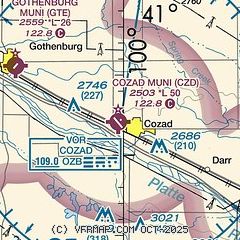
|
| Airport distance calculator |
|---|
|
|
| Sunrise and sunset |
|---|
|
Times for 24-Jul-2026
| | Local
(UTC-5) | | Zulu
(UTC) |
|---|
| Morning civil twilight | | 05:58 | | 10:58 |
| Sunrise | | 06:30 | | 11:30 |
| Sunset | | 21:03 | | 02:03 |
| Evening civil twilight | | 21:35 | | 02:35 |
|
| Current date and time |
|---|
| Zulu (UTC) | 24-Jul-2026 21:12:44 |
|---|
| Local (UTC-5) | 24-Jul-2026 16:12:44 |
|---|
|
| METAR |
|---|
KLXN
12nm SE | 242055Z AUTO 19003KT 10SM SCT019 26/21 A3000 RMK AO2 T02640211
|
|
| TAF |
|---|
KLBF
33nm NW | 241733Z 2418/2518 20004KT P6SM BKN015 FM241900 20004KT P6SM SKC FM242200 16004KT P6SM SKC FM250900 VRB03KT P6SM SKC FM251600 21007KT P6SM SCT250
|
|
| NOTAMs |
|---|
NOTAMs are issued by the DoD/FAA and will open in a separate window not controlled by AirNav.
|
|

