FAA INFORMATION EFFECTIVE 09 JULY 2026
Location
| FAA Identifier: | GTE |
| Lat/Long: | 40-55-31.7400N 100-08-47.6500W
40-55.529000N 100-08.794167W
40.9254833,-100.1465694
(estimated) |
| Elevation: | 2558.8 ft. / 780 m (estimated) |
| Variation: | 08E (1985) |
| From city: | 1 mile E of GOTHENBURG, NE |
| Time zone: | UTC -5 (UTC -6 during Standard Time) |
| Zip code: | 69138 |
Airport Operations
| Airport use: | Open to the public |
| Activation date: | 11/1948 |
| Control tower: | no |
| ARTCC: | DENVER CENTER |
| FSS: | COLUMBUS FLIGHT SERVICE STATION |
| NOTAMs facility: | OLU (NOTAM-D service available) |
| Attendance: | UNATNDD |
| Wind indicator: | lighted |
| Segmented circle: | no |
| Lights: | ACTVT MIRL RWY 03/21 - CTAF. |
| Beacon: | white-green (lighted land airport)
Operates sunset to sunrise. |
Airport Communications
| CTAF/UNICOM: | 122.8 |
| WX AWOS-3 at LXN (19 nm SE): | 121.025 (308-324-5975) |
- APCH/DEP CTL SVC PRVDD BY DENVER ARTCC (ZDV) ON FREQS 132.7/226.675 (NORTH PLATTE RCAG).
Nearby radio navigation aids
| VOR radial/distance | | VOR name | | Freq | | Var |
|---|
| OZBr288/(7.3) | | COZAD VOR | | 109.00 | | 09E |
| LBFr094/28.2 | | NORTH PLATTE VOR/DME | | 117.40 | | 11E |
| CUZr204/39.4 | | CUSTER COUNTY VOR/DME | | 108.20 | | 08E |
Airport Services
| Fuel available: | 100LL
100LL:FUEL AVBL H24 VIA CREDIT CARD. |
| Parking: | hangars and tiedowns |
| Bottled oxygen: | NONE |
| Bulk oxygen: | NONE |
Runway Information
Runway 3/21
| Dimensions: | 2599 x 50 ft. / 792 x 15 m |
| Surface: | concrete, in good condition |
| Weight bearing capacity: | |
| Runway edge lights: | medium intensity |
| RUNWAY 3 | | RUNWAY 21 |
| Latitude: | 40-55.408388N | | 40-55.743703N |
| Longitude: | 100-09.074040W | | 100-08.723553W |
| Elevation: | 2556.0 ft. | | 2558.8 ft. |
| Traffic pattern: | left | | left |
| Runway heading: | 030 magnetic, 038 true | | 210 magnetic, 218 true |
| Displaced threshold: | 70 ft. | | no |
| Markings: | nonprecision, in good condition | | nonprecision, in good condition |
| Touchdown point: | yes, no lights | | yes, no lights |
| Obstructions: | 11 ft. other, 279 ft. from runway, 170 ft. left of centerline, 7:1 slope to clear
CTLG OBSTN FM DEP THR IS TWR 2157 FT OUT, 107 FT ABV, 514 FT R, CLNC SLP 20:1. | | 19 ft. road, 353 ft. from runway, 273 ft. right of centerline, 8:1 slope to clear |
Runway 14/32
| Dimensions: | 3300 x 150 ft. / 1006 x 46 m |
| Surface: | turf, in good condition |
| RUNWAY 14 | | RUNWAY 32 |
| Latitude: | 40-55.724000N | | 40-55.260000N |
| Longitude: | 100-08.898333W | | 100-08.525333W |
| Elevation: | 2555.0 ft. | | 2555.0 ft. |
| Traffic pattern: | left | | left |
| Runway heading: | 141 magnetic, 149 true | | 321 magnetic, 329 true |
| Touchdown point: | yes, no lights | | yes, no lights |
Airport Ownership and Management from official FAA records
| Ownership: | Publicly-owned |
| Owner: | CITY OF GOTHENBURG
P.O. BOX 267
GOTHENBURG, NE 69138-0267
Phone (308) 529-2594
CHAIRMAN OF ARPT AUTH; ROGER TEDERMAN. |
| Manager: | GARY GREER
P.O. BOX 267
GOTHENBURG, NE 69138-0267
Phone 308-529-2594 |
Additional Remarks
| - | RWY 14/32 NOT PLOWED WINTER MONTHS. |
| - | MIGRATORY BIRDS INVOF APRT SPRING AND FALL. |
| - | FOR CD CTC DENVER ARTCC AT 303-651-4257. |
Instrument Procedures
NOTE: All procedures below are presented as PDF files. If you need a reader for these files, you should download the free Adobe Reader.NOT FOR NAVIGATION. Please procure official charts for flight.
FAA instrument procedures published for use from 09 July 2026 at 0901Z to 06 August 2026 at 0900Z.
IAPs - Instrument Approach Procedures |
|---|
| RNAV (GPS) RWY 03 | |
download (232KB) |
| RNAV (GPS) RWY 21 | |
download (194KB) |
| VOR-A | |
download (198KB) |
| NOTE: Special Take-Off Minimums/Departure Procedures apply | |
download (365KB) |
Other nearby airports with instrument procedures:
KCZD - Cozad Municipal Airport (7 nm SE)
KLXN - Jim Kelly Field Airport (19 nm SE)
47V - Curtis Municipal Airport (23 nm SW)
KLBF - North Platte Regional Airport/Lee Bird Field (27 nm NW)
KCSB - Cambridge Municipal Airport (37 nm S)
|
|

Road maps at:
MapQuest
Bing
Google
| Aerial photo |
|---|
WARNING: Photo may not be current or correct

Do you have a better or more recent aerial photo of Gothenburg Municipal Airport that you would like to share? If so, please send us your photo.
|
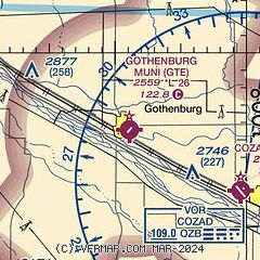
| Sectional chart |
|---|
|
| Airport distance calculator |
|---|
|
|
| Sunrise and sunset |
|---|
|
Times for 29-Jul-2026
| | Local
(UTC-5) | | Zulu
(UTC) |
|---|
| Morning civil twilight | | 06:04 | | 11:04 |
| Sunrise | | 06:35 | | 11:35 |
| Sunset | | 20:59 | | 01:59 |
| Evening civil twilight | | 21:30 | | 02:30 |
|
| Current date and time |
|---|
| Zulu (UTC) | 29-Jul-2026 15:58:26 |
|---|
| Local (UTC-5) | 29-Jul-2026 10:58:26 |
|---|
|
| METAR |
|---|
KLXN
19nm SE | 291535Z AUTO 00000KT 10SM CLR 25/21 A2998 RMK AO2 T02460206
|
KLBF
26nm NW | 291553Z AUTO 09005KT 10SM CLR 28/23 A2998 RMK AO2 SLP121 T02780228
|
KBBW
37nm NE | 291553Z AUTO VRB03KT 10SM CLR 27/21 A2996 RMK AO2 SLP121 T02670211
|
KCSB
37nm S | 291535Z AUTO VRB03KT 10SM CLR 28/21 A2996 RMK AO2
|
|
| TAF |
|---|
KLBF
26nm NW | 291131Z 2912/3012 VRB03KT P6SM SCT100 FM291800 13008G18KT P6SM SCT250 FM300300 14007KT P6SM OVC250
|
|
| NOTAMs |
|---|
NOTAMs are issued by the DoD/FAA and will open in a separate window not controlled by AirNav.
|
|

