FAA INFORMATION EFFECTIVE 27 NOVEMBER 2025
Location
| FAA Identifier: | DLC |
| Lat/Long: | 34-26-56.6000N 079-22-06.9000W
34-26.943333N 079-22.115000W
34.4490556,-79.3685833
(estimated) |
| Elevation: | 133.1 ft. / 40.6 m (surveyed) |
| Variation: | 06W (1985) |
| From city: | 3 miles N of DILLON, SC |
| Time zone: | UTC -5 (UTC -4 during Daylight Saving Time) |
| Zip code: | 29536 |
Airport Operations
| Airport use: | Open to the public |
| Activation date: | 08/1960 |
| Control tower: | no |
| ARTCC: | JACKSONVILLE CENTER |
| FSS: | ANDERSON FLIGHT SERVICE STATION |
| NOTAMs facility: | AND (NOTAM-D service available) |
| Attendance: | UNATNDD |
| Wind indicator: | yes |
| Segmented circle: | yes |
| Lights: | SS-SR |
| Beacon: | white-green (lighted land airport)
Operates sunset to sunrise. |
Airport Communications
| CTAF: | 122.9 |
| FLORENCE APPROACH: | 118.6 |
| FLORENCE DEPARTURE: | 118.6 |
| WX AWOS-3PT at MAO (16 nm S): | 119.875 (843-423-4231) |
| WX ASOS at LBT (18 nm NE): | 134.775 (910-739-7120) |
- APCH/DEP SVC PRVDD BY JACKSONVILLE ARTCC ON FREQS 133.45/306.3 (FLORENCE RCAG) WHEN FLORENCE APCH CTL CLSD.
Nearby radio navigation aids
| VOR radial/distance | | VOR name | | Freq | | Var |
|---|
| FLOr051/19.3 | | FLORENCE VORTAC | | 115.20 | | 03W |
| NDB name | | Hdg/Dist | | Freq | | Var | | ID |
|---|
| JIGEL | | 251/12.8 | | 384 | | 08W | | JB | .--- -... |
| CAMP | | 295/34.2 | | 227 | | 07W | | CPC | -.-. .--. -.-. |
| HARTSVILLE | | 093/37.3 | | 341 | | 07W | | HVS | .... ...- ... |
Airport Services
| Parking: | tiedowns |
| Airframe service: | NONE |
| Powerplant service: | NONE |
| Bottled oxygen: | NONE |
| Bulk oxygen: | NONE |
Runway Information
Runway 7/25
| Dimensions: | 3000 x 60 ft. / 914 x 18 m |
| Surface: | asphalt/aggregate friction seal coat, in fair condition |
| Weight bearing capacity: | |
| Runway edge lights: | medium intensity |
| RUNWAY 7 | | RUNWAY 25 |
| Latitude: | 34-26.834567N | | 34-27.051700N |
| Longitude: | 079-22.383617W | | 079-21.847200W |
| Elevation: | 133.1 ft. | | 117.3 ft. |
| Traffic pattern: | left | | left |
| Runway heading: | 070 magnetic, 064 true | | 250 magnetic, 244 true |
| Markings: | nonprecision, in good condition | | nonprecision, in good condition |
| Touchdown point: | yes, no lights | | yes, no lights |
| Obstructions: | 44 ft. pole, 773 ft. from runway, 258 ft. right of centerline, 12:1 slope to clear | | 52 ft. tree, 302 ft. from runway, 135 ft. left of centerline, 1:1 slope to clear
RWY 25 APCH HAS LINES OF TREES PARL TO THE RWY 135 FT BOTH SIDES OF CNTRLN. |
Airport Ownership and Management from official FAA records
| Ownership: | Publicly-owned |
| Owner: | DILLON COUNTY
PO BOX 449
DILLON, SC 29536
Phone (843) 774-1401 |
| Manager: | TIM HARPER
PO BOX 449
DILLON, SC 29536
Phone 843-845-8529 |
Additional Remarks
| - | FOR CD CTC FLORENCE APCH AT 843-665-0632, WHEN APCH CLSD CTC JACKSONVILLE ARTCC AT 904-845-1592. |
Instrument Procedures
NOTE: All procedures below are presented as PDF files. If you need a reader for these files, you should download the free Adobe Reader.NOT FOR NAVIGATION. Please procure official charts for flight.
FAA instrument procedures published for use from 27 November 2025 at 0901Z to 25 December 2025 at 0900Z.
IAPs - Instrument Approach Procedures |
|---|
| RNAV (GPS)-A | |
download (174KB) |
| NOTE: Special Take-Off Minimums/Departure Procedures apply | |
download (141KB) |
Other nearby airports with instrument procedures:
KMAO - Marion County Airport (16 nm S)
KLBT - Lumberton Regional Airport (18 nm NE)
KMEB - Laurinburg/Maxton Airport (21 nm N)
KBBP - Marlboro County Jetport/H E Avent Field Airport (21 nm NW)
KFLO - Florence Regional Airport (24 nm SW)
|
|

Road maps at:
MapQuest
Bing
Google
| Aerial photo |
|---|
WARNING: Photo may not be current or correct

Do you have a better or more recent aerial photo of Dillon County Airport that you would like to share? If so, please send us your photo.
|
| Sectional chart |
|---|
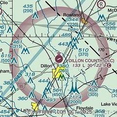
|
| Airport distance calculator |
|---|
|
|
| Sunrise and sunset |
|---|
|
Times for 30-Nov-2025
| | Local
(UTC-5) | | Zulu
(UTC) |
|---|
| Morning civil twilight | | 06:38 | | 11:38 |
| Sunrise | | 07:06 | | 12:06 |
| Sunset | | 17:06 | | 22:06 |
| Evening civil twilight | | 17:34 | | 22:34 |
|
| Current date and time |
|---|
| Zulu (UTC) | 01-Dec-2025 02:04:28 |
|---|
| Local (UTC-5) | 30-Nov-2025 21:04:28 |
|---|
|
| METAR |
|---|
KMAO
16nm S | 010155Z AUTO 35004KT 10SM SCT014 BKN110 12/08 A3020 RMK AO2
|
KLBT
17nm NE | 010156Z AUTO 00000KT 10SM OVC038 12/08 A3018 RMK AO2 SLP221 T01220078
|
KMEB
20nm N | 010152Z AUTO 32006KT 10SM FEW021 OVC065 11/07 A3020 RMK AO2 SLP228 T01060067
|
KBBP
21nm NW | 010155Z AUTO 32004KT 10SM BKN022 OVC026 09/07 A3020 RMK AO2
|
KFLO
24nm SW | 010153Z 34003KT 10SM SCT049 BKN055 OVC110 11/08 A3020 RMK AO2 SLP225 T01110083
|
KUDG
25nm W | 010156Z AUTO 36003KT 10SM -RA OVC028 11/08 A3020 RMK AO2 RAB47 SLP229 P0000 T01060078 $
|
|
| TAF |
|---|
KLBT
17nm NE | 301723Z 3018/0118 VRB04KT P6SM VCSH BKN060 FM010800 03010KT P6SM SCT060
|
|
| NOTAMs |
|---|
NOTAMs are issued by the DoD/FAA and will open in a separate window not controlled by AirNav.
|
|

