FAA INFORMATION EFFECTIVE 14 MAY 2026
Location
| FAA Identifier: | MEB |
| Lat/Long: | 34-47-31.8200N 079-21-57.2260W
34-47.530333N 079-21.953767W
34.7921722,-79.3658961
(estimated) |
| Elevation: | 215.6 ft. / 65.7 m (surveyed) |
| Variation: | 08W (2005) |
| From city: | 3 miles N of MAXTON, NC |
| Time zone: | UTC -4 (UTC -5 during Standard Time) |
| Zip code: | 28352 |
Airport Operations
| Airport use: | Open to the public |
| Activation date: | 05/1943 |
| Control tower: | no |
| ARTCC: | WASHINGTON CENTER |
| FSS: | RALEIGH FLIGHT SERVICE STATION |
| NOTAMs facility: | MEB (NOTAM-D service available) |
| Attendance: | MON - FRI 0800-1800, ALL SAT - SUN 0900-1700
FOR SVC AFT HRS CALL 910-390-6122 OR 315-807-4759. |
| Wind indicator: | lighted |
| Segmented circle: | yes |
| Lights: | ACTVT MALSR RWY 05; PAPI RWY 05 & 23; HIRL RWY 05/23 - CTAF. |
| Beacon: | white-green (lighted land airport)
Operates sunset to sunrise. |
Airport Communications
| CTAF/UNICOM: | 122.8 |
| WX ASOS: | 134.125 (910-844-5338) |
| FAYETTEVILLE APPROACH: | 127.8 |
| FAYETTEVILLE DEPARTURE: | 127.8 |
| WX ASOS at HFF (16 nm NW): | 141.25 (910-396-7804) |
| WX ASOS at LBT (19 nm SE): | 134.775 (910-739-7120) |
Nearby radio navigation aids
| VOR radial/distance | | VOR name | | Freq | | Var |
|---|
| FAYr248/26.8 | | FAYETTEVILLE VOR/DME | | 114.85 | | 04W |
| SDZr160/27.6 | | SANDHILLS VORTAC | | 111.80 | | 03W |
| FLOr026/36.5 | | FLORENCE VORTAC | | 115.20 | | 03W |
| NDB name | | Hdg/Dist | | Freq | | Var | | ID |
|---|
| MAXTN | | 055/5.2 | | 257 | | 08W | | ME | -- . |
Airport Services
| Fuel available: | 100LL JET-A1+
100LL:24 HR SELF SVC WITH CREDIT CARD. |
| Parking: | hangars and tiedowns |
| Airframe service: | MINOR
CTC AMGR FOR ACFT RPR SVC. |
| Powerplant service: | MINOR |
| Bottled oxygen: | NONE |
| Bulk oxygen: | NONE |
Runway Information
Runway 5/23
| Dimensions: | 6503 x 100 ft. / 1982 x 30 m |
| Surface: | asphalt, in excellent condition |
| Weight bearing capacity: | | Single wheel: | 60.0 | | Double wheel: | 160.0 | | Double tandem: | 256.0 |
|
| Runway edge lights: | high intensity |
| RUNWAY 5 | | RUNWAY 23 |
| Latitude: | 34-47.421742N | | 34-48.168895N |
| Longitude: | 079-22.318317W | | 079-21.386543W |
| Elevation: | 215.6 ft. | | 200.0 ft. |
| Traffic pattern: | left | | right |
| Runway heading: | 054 magnetic, 046 true | | 234 magnetic, 226 true |
| Displaced threshold: | no | | 187 ft. |
| Markings: | precision, in good condition | | precision, in good condition |
| Visual slope indicator: | 4-light PAPI on left (3.00 degrees glide path) | | 4-light PAPI on left (3.00 degrees glide path) |
| Approach lights: | MALSR: 1,400 foot medium intensity approach lighting system with runway alignment indicator lights | | |
| Touchdown point: | yes, no lights | | yes, no lights |
| Instrument approach: | ILS | | |
| Obstructions: | none | | 20 ft. road, 534 ft. from runway, 16:1 slope to clear |
Runway 13/31
| Dimensions: | 3536 x 75 ft. / 1078 x 23 m
2750 FT CONC STOPWAY ON SE END. |
| Surface: | concrete, in fair condition |
| Weight bearing capacity: | | Single wheel: | 25.0 | | Double wheel: | 35.0 |
|
| RUNWAY 13 | | RUNWAY 31 |
| Latitude: | 34-47.249873N | | 34-46.836028N |
| Longitude: | 079-22.388795W | | 079-21.891365W |
| Elevation: | 215.5 ft. | | 207.0 ft. |
| Traffic pattern: | right | | left |
| Runway heading: | 143 magnetic, 135 true | | 323 magnetic, 315 true |
| Markings: | basic, in fair condition | | basic, in fair condition |
| Touchdown point: | yes, no lights | | yes, no lights |
| Obstructions: | 44 ft. trees, 1721 ft. from runway, 87 ft. right of centerline, 34:1 slope to clear | | 45 ft. trees, 749 ft. from runway, 294 ft. left of centerline, 12:1 slope to clear |
Airport Ownership and Management from official FAA records
| Ownership: | Publicly-owned |
| Owner: | TOWN OF LAURINBURG & MAXTON
16701 AIRPORT RD
MAXTON, NC 28364
Phone 910-844-5081 |
| Manager: | SETH HATCHELL
16701 AIRPORT RD
MAXTON, NC 28364
Phone 910-390-6122 |
Additional Remarks
| - | MIL ACFT FRQLY OPER FM CLSD PTN OF RWY 13/31 & CLSD RWY 18/36. |
| - | HVY PAJA AT SOUTH END OF CLSD RWY 18/36 & SOUTH SIDE RWY 13/31. |
| - | FARMING EQPT AND MIL OPS ON & INVOF ARPT. |
| - | RWY 13/31 DALGT USE ONLY. |
| - | NO LN OF SIGHT BTN RWY ENDS. |
| - | FOR CD IF UNA VIA GCO CTC FAYETTEVILLE APCH AT 910-484-8012. |
Instrument Procedures
NOTE: All procedures below are presented as PDF files. If you need a reader for these files, you should download the free Adobe Reader.NOT FOR NAVIGATION. Please procure official charts for flight.
FAA instrument procedures published for use from 14 May 2026 at 0901Z to 11 June 2026 at 0900Z.
IAPs - Instrument Approach Procedures |
|---|
| ILS OR LOC RWY 05 | |
download (217KB) |
| RNAV (GPS) RWY 05 | |
download (230KB) |
| RNAV (GPS) RWY 23 | |
download (189KB) |
| NOTE: Special Alternate Minimums apply | |
download (167KB) |
| NOTE: Special Take-Off Minimums/Departure Procedures apply | |
download (363KB) |
Other nearby airports with instrument procedures:
KHFF - Mackall Army Airfield (16 nm NW)
5W4 - P K Airpark (16 nm NE)
KLBT - Lumberton Regional Airport (19 nm SE)
KRCZ - Richmond County Airport (20 nm W)
KDLC - Dillon County Airport (21 nm S)
|
|

Road maps at:
MapQuest
Bing
Google
| Aerial photo |
|---|
WARNING: Photo may not be current or correct
 Photo by Seth Hatchell
Taken in the Summer of 2020
looking southwest.
Photo by Seth Hatchell
Taken in the Summer of 2020
looking southwest.
Do you have a better or more recent aerial photo of Laurinburg/Maxton Airport that you would like to share? If so, please send us your photo.
|
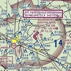
| Sectional chart |
|---|
|
CAUTION: Diagram may not be current

| Airport distance calculator |
|---|
|
|
| Sunrise and sunset |
|---|
|
Times for 02-Jun-2026
| | Local
(UTC-4) | | Zulu
(UTC) |
|---|
| Morning civil twilight | | 05:37 | | 09:37 |
| Sunrise | | 06:06 | | 10:06 |
| Sunset | | 20:25 | | 00:25 |
| Evening civil twilight | | 20:54 | | 00:54 |
|
| Current date and time |
|---|
| Zulu (UTC) | 02-Jun-2026 20:29:47 |
|---|
| Local (UTC-4) | 02-Jun-2026 16:29:47 |
|---|
|
| METAR |
|---|
| KMEB | 021952Z AUTO 29005KT 10SM CLR 23/13 A3012 RMK AO2 SLP199 T02280128
|
KHFF
15nm NW | 021955Z AUTO 06010KT 10SM FEW070 BKN140 26/09 A3010 RMK AO2 SLP193 T02570091 $
|
KLBT
19nm SE | 021956Z AUTO VRB05KT 10SM CLR 24/12 A3010 RMK AO2 RAE01 SLP192 P0000 T02390117
|
|
| TAF |
|---|
KLBT
19nm SE | 021720Z 0218/0318 03009KT P6SM BKN090 FM030000 04005KT P6SM SCT090 FM030800 02003KT P6SM SKC FM031600 02009KT P6SM SKC
|
|
| NOTAMs |
|---|
NOTAMs are issued by the DoD/FAA and will open in a separate window not controlled by AirNav.
|
|


