FAA INFORMATION EFFECTIVE 14 MAY 2026
Location
| FAA Identifier: | FLO |
| Lat/Long: | 34-11-07.3080N 079-43-25.9790W
34-11.121800N 079-43.432983W
34.1853633,-79.7238831
(estimated) |
| Elevation: | 146.6 ft. / 44.7 m (surveyed) |
| Variation: | 09W (2025) |
| From city: | 3 miles E of FLORENCE, SC |
| Time zone: | UTC -4 (UTC -5 during Standard Time) |
| Zip code: | 29506 |
Airport Operations
| Airport use: | Open to the public |
| Activation date: | 10/1937 |
| Control tower: | yes |
| ARTCC: | JACKSONVILLE CENTER |
| FSS: | ANDERSON FLIGHT SERVICE STATION |
| NOTAMs facility: | FLO (NOTAM-D service available) |
| Attendance: | 0600-2000 |
| Wind indicator: | lighted |
| Segmented circle: | yes |
| Lights: | WHEN ATCT CLSD ACTVT MALSR RWY 09; REIL RWY 01, 19 & 27; PAPI RWY 01 & 19; HIRL RWY 09/27; AND TWY LGTS - CTAF. |
| Beacon: | white-green (lighted land airport)
Operates sunset to sunrise. |
| Fire and rescue: | ARFF index B |
Airport Communications
| CTAF: | 125.1 |
| UNICOM: | 122.95 |
| ATIS: | 123.625 |
| WX ASOS: | PHONE 843-665-1306 |
| FLORENCE GROUND: | 121.9 353.85 [0630-2200] |
| FLORENCE TOWER: | 125.1 353.85 [0630-2200] |
| FLORENCE APPROACH: | 118.6 ;256-074 135.25 ;075-255 316.15 ;075-255 341.7 ;256-074 [0630-2200] |
| FLORENCE DEPARTURE: | 118.6 ;256-074 135.25 ;075-255 316.15 ;075-255 341.7 ;256-074 [0630-2200] |
| CLEARANCE DELIVERY: | 121.9 353.85 |
| WX AWOS-3PT at UDG (18 nm NW): | 119.925 (843-393-8220) |
| WX AWOS-3PT at MAO (19 nm E): | 119.875 (843-423-4231) |
- APCH/DEP SVC PRVDD BY JACKSONVILLE ARTCC ON FREQS 133.45/306.3 (FLORENCE RCAG) WHEN FLORENCE APCH CTL CLSD.
Nearby radio navigation aids
| VOR radial/distance | | VOR name | | Freq | | Var |
|---|
| FLOr232/4.4 | | FLORENCE VORTAC | | 115.20 | | 03W |
| CTFr139/39.0 | | CHESTERFIELD VOR/DME | | 114.55 | | 03W |
| NDB name | | Hdg/Dist | | Freq | | Var | | ID |
|---|
| EVANS | | 012/19.9 | | 420 | | 06W | | CFY | -.-. ..-. -.-- |
| HARTSVILLE | | 131/23.7 | | 341 | | 07W | | HVS | .... ...- ... |
Airport Services
| Fuel available: | 100LL JET-A |
| Parking: | hangars and tiedowns |
| Airframe service: | MAJOR |
| Powerplant service: | MAJOR |
| Bottled oxygen: | HIGH |
| Bulk oxygen: | HIGH |
Runway Information
Runway 9/27
| Dimensions: | 6502 x 150 ft. / 1982 x 46 m |
| Surface: | asphalt/grooved, in good condition |
| Weight bearing capacity: | | Single wheel: | 97.0 | | Double wheel: | 156.0 | | Double tandem: | 261.0 |
|
| Runway edge lights: | high intensity |
| RUNWAY 9 | | RUNWAY 27 |
| Latitude: | 34-11.120812N | | 34-11.241215N |
| Longitude: | 079-44.036615W | | 079-42.754957W |
| Elevation: | 146.5 ft. | | 121.5 ft. |
| Traffic pattern: | left | | left |
| Runway heading: | 093 magnetic, 084 true | | 273 magnetic, 264 true |
| Markings: | precision, in good condition | | nonprecision, in good condition |
| Visual slope indicator: | 4-light PAPI on left (3.00 degrees glide path) | | 4-light PAPI on left (3.00 degrees glide path) |
| Approach lights: | MALSR: 1,400 foot medium intensity approach lighting system with runway alignment indicator lights | | |
| Runway end identifier lights: | | | yes |
| Touchdown point: | yes, no lights | | yes, no lights |
| Instrument approach: | ILS/DME | | |
Runway 1/19
| Dimensions: | 6000 x 150 ft. / 1829 x 46 m |
| Surface: | asphalt, in poor condition
WIDESPREAD CRACKING; UNEVEN SURFACE |
| Weight bearing capacity: | | Single wheel: | 87.0 | | Double wheel: | 139.0 | | Double tandem: | 238.0 |
|
| Runway edge lights: | medium intensity |
| RUNWAY 1 | | RUNWAY 19 |
| Latitude: | 34-10.563218N | | 34-11.552002N |
| Longitude: | 079-43.488813W | | 079-43.457782W |
| Elevation: | 112.2 ft. | | 143.4 ft. |
| Traffic pattern: | left | | left |
| Runway heading: | 010 magnetic, 001 true | | 190 magnetic, 181 true |
| Markings: | nonprecision, in fair condition | | nonprecision, in good condition |
| Visual slope indicator: | 4-light PAPI on left (3.00 degrees glide path) | | 4-light PAPI on left (3.00 degrees glide path) |
| Runway end identifier lights: | yes | | yes |
| Touchdown point: | yes, no lights | | yes, no lights |
| Obstructions: | 42 ft. tree, 1250 ft. from runway, 25:1 slope to clear | | 90 ft. trees, 2000 ft. from runway, 20:1 slope to clear |
Airport Ownership and Management from official FAA records
| Ownership: | Publicly-owned |
| Owner: | PEE DEE REGIONAL ARPT AUTHORITY
2100 TERMINAL DRIVE
FLORENCE, SC 29506
Phone 843-669-5001 |
| Manager: | BRAD BEADLES
2100 TERMINAL DRIVE
FLORENCE, SC 29506
Phone 843-669-0550 |
Additional Remarks
| A39-09/27 | PCR VALUE: 1130/F/A/X/T |
| A39-01/19 | PCR VALUE: 190/F/C/X/T |
| - | 24 HR PPR FOR UNSKED ACR OPNS WITH MORE THAN 30 PSGR SEATS; CTC AMGR AT 843-669-5001. |
| - | FOR CD IF UNA TO CTC ON FSS FREQ, CTC FLORENCE APCH AT 843-665-0632, WHEN APCH CLSD CTC JACKSONVILLE ARTCC AT 904-845-1592. |
Instrument Procedures
NOTE: All procedures below are presented as PDF files. If you need a reader for these files, you should download the free Adobe Reader.NOT FOR NAVIGATION. Please procure official charts for flight.
FAA instrument procedures published for use from 14 May 2026 at 0901Z to 11 June 2026 at 0900Z.
IAPs - Instrument Approach Procedures |
|---|
| ILS OR LOC RWY 09 | |
download (242KB) |
| RNAV (GPS) RWY 01 | |
download (218KB) |
| RNAV (GPS) RWY 09 | |
download (240KB) |
| RNAV (GPS) RWY 19 | |
download (238KB) |
| RNAV (GPS) RWY 27 | |
download (236KB) |
| VOR OR TACAN-A | |
download (230KB) |
| NOTE: Special Alternate Minimums apply | |
download (144KB) |
| NOTE: Special Take-Off Minimums/Departure Procedures apply | |
download (357KB) |
Other nearby airports with instrument procedures:
KUDG - Darlington County Airport (18 nm NW)
KMAO - Marion County Airport (19 nm E)
51J - Lake City Municipal Airport-CJ Evans Field (20 nm S)
KHVS - Hartsville Regional Airport (24 nm NW)
KDLC - Dillon County Airport (24 nm NE)
|
|

Road maps at:
MapQuest
Bing
Google
| Aerial photo |
|---|
WARNING: Photo may not be current or correct
 Photo by Brian Corley
Photo taken 04-Feb-2015
looking west.
Photo by Brian Corley
Photo taken 04-Feb-2015
looking west.
Do you have a better or more recent aerial photo of Florence Regional Airport that you would like to share? If so, please send us your photo.
|
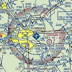
| Sectional chart |
|---|
|
| Airport distance calculator |
|---|
|
|
| Sunrise and sunset |
|---|
|
Times for 30-May-2026
| | Local
(UTC-4) | | Zulu
(UTC) |
|---|
| Morning civil twilight | | 05:41 | | 09:41 |
| Sunrise | | 06:10 | | 10:10 |
| Sunset | | 20:23 | | 00:23 |
| Evening civil twilight | | 20:52 | | 00:52 |
|
| Current date and time |
|---|
| Zulu (UTC) | 30-May-2026 12:21:38 |
|---|
| Local (UTC-4) | 30-May-2026 08:21:38 |
|---|
|
| METAR |
|---|
| KFLO | 301153Z 25003KT 8SM FEW080 23/21 A2991 RMK AO2 SLP126 T02280211 10228 20217 53005
|
KUDG
18nm NW | 301156Z AUTO 21005KT OVC075 23/22 A2991 RMK AO2 SLP129 T02280222 10228 20222 50005 PWINO $
|
KMAO
19nm E | 301155Z AUTO 00000KT 10SM CLR 21/21 A2991 RMK AO2
|
|
| TAF |
|---|
| KFLO | 301120Z 3012/3112 27007KT P6SM -RA SCT040 OVC120 FM301500 27006KT P6SM -SHRA SCT040 OVC090 TEMPO 3016/3020 4SM TSRA BKN040CB FM302100 31004KT P6SM BKN120 FM310400 07011KT P6SM SCT120
|
|
| NOTAMs |
|---|
NOTAMs are issued by the DoD/FAA and will open in a separate window not controlled by AirNav.
|
|


