FAA INFORMATION EFFECTIVE 09 JULY 2026
Location
| FAA Identifier: | DLS |
| Lat/Long: | 45-37-09.6786N 121-10-05.7926W
45-37.161310N 121-10.096543W
45.6193552,-121.1682757
(estimated) |
| Elevation: | 246.5 ft. / 75.1 m (surveyed) |
| Variation: | 15E (2015) |
| From city: | 2 miles NE of THE DALLES, OR |
| Time zone: | UTC -7 (UTC -8 during Standard Time) |
| Zip code: | 98617 |
Airport Operations
| Airport use: | Open to the public |
| Activation date: | 06/1943 |
| Control tower: | no |
| ARTCC: | SEATTLE CENTER |
| FSS: | SEATTLE FLIGHT SERVICE STATION |
| NOTAMs facility: | DLS (NOTAM-D service available) |
| Attendance: | 0800-1700 |
| Wind indicator: | lighted |
| Segmented circle: | yes |
| Lights: | ACTVT MIRL RYS 13/31 & 07/25, & REIL RY 31 - CTAF. REIL OPERATES ON 7 CLICKS ONLY. |
| Beacon: | white-green (lighted land airport)
Operates sunset to sunrise. |
Airport Communications
| CTAF/UNICOM: | 123.0 |
| WX ASOS: | 135.175 (509-767-1726) |
| WX AWOS-3 at 4S2 (16 nm W): | 134.375 (541-386-2386) |
- APCH/DEP CTL SVC PRVDD SEATTLE ARTCC (ZSE) ON FREQS 119.65/257.6 (KLICKITAT RCAG).
Nearby radio navigation aids
| VOR radial/distance | | VOR name | | Freq | | Var |
|---|
| LTJr186/6.3 | | KLICKITAT VOR/DME | | 112.30 | | 21E |
Airport Services
| Fuel available: | 100LL JET-A1 |
| Parking: | tiedowns |
| Airframe service: | MAJOR |
| Powerplant service: | MAJOR |
| Bottled oxygen: | NONE |
| Bulk oxygen: | NONE |
Runway Information
Runway 13/31
| Dimensions: | 5097 x 100 ft. / 1554 x 30 m |
| Surface: | asphalt, in good condition |
| Weight bearing capacity: | | PCN 32 /F/C/X/T | | Single wheel: | 30.0 | | Double wheel: | 30.0 |
|
| Runway edge lights: | medium intensity |
| RUNWAY 13 | | RUNWAY 31 |
| Latitude: | 45-37.411800N | | 45-36.728067N |
| Longitude: | 121-10.406050W | | 121-09.714017W |
| Elevation: | 210.9 ft. | | 238.9 ft. |
| Traffic pattern: | left | | left |
| Runway heading: | 130 magnetic, 145 true | | 310 magnetic, 325 true |
| Displaced threshold: | 200 ft. | | no |
| Markings: | basic, in good condition | | basic, in good condition |
| Runway end identifier lights: | | | yes |
| Touchdown point: | yes, no lights | | yes, no lights |
| Obstructions: | 15 ft. trees, 201 ft. from runway, 107 ft. left of centerline
CNTLG OBSTN EXCEEDS 45 DEG SLP. | | none |
Runway 7/25
| Dimensions: | 4647 x 100 ft. / 1416 x 30 m |
| Surface: | asphalt, in good condition |
| Weight bearing capacity: | | Single wheel: | 30.0 | | Double wheel: | 30.0 |
|
| Runway edge lights: | medium intensity |
| RUNWAY 7 | | RUNWAY 25 |
| Latitude: | 45-37.248233N | | 45-37.274800N |
| Longitude: | 121-10.681083W | | 121-09.592167W |
| Elevation: | 211.1 ft. | | 242.7 ft. |
| Traffic pattern: | left | | left |
| Runway heading: | 073 magnetic, 088 true | | 253 magnetic, 268 true |
| Displaced threshold: | 440 ft. | | 196 ft. |
| Markings: | precision, in good condition | | precision, in good condition |
| Touchdown point: | yes, no lights | | yes, no lights |
| Instrument approach: | | | LDA/DME |
| Obstructions: | 34 ft. pole, 796 ft. from runway, 112 ft. left of centerline, 17:1 slope to clear
RWY 07 +15 FTROAD, 0 FT FM END, 200 FT R. | | none
THLD DSPLCD TO PROVIDE SAFETY AREA. |
Airport Ownership and Management from official FAA records
| Ownership: | Publicly-owned |
| Owner: | CITY OF THE DALLES/KLICKITAT COUNTY
PO BOX 285
DALLES PORT, WA 98617
Phone 509-767-2272 |
| Manager: | JEFF RENARD
PO BOX 285
DALLES PORT, WA 98617
Phone 509-767-2272
ADNL CTC - 541-288-6766. MANAGER@FLYCGRA.COM. |
Additional Remarks
| - | MTNS BYD 5000' APCH RY 31. |
| - | ALL TWYS MARKED WITH REFLECTORS. |
| - | WATERFOWL ON AND INVOF ARPT. |
| - | PRIOR PERMISSION REQUIRED FOR OVERWEIGHT LNDGS. |
| - | FOR CD CTC SEATTLE ARTCC AT 253-351-3694. |
Instrument Procedures
NOTE: All procedures below are presented as PDF files. If you need a reader for these files, you should download the free Adobe Reader.NOT FOR NAVIGATION. Please procure official charts for flight.
FAA instrument procedures published for use from 09 July 2026 at 0901Z to 06 August 2026 at 0900Z.
IAPs - Instrument Approach Procedures |
|---|
| RNAV (GPS)-A | |
download (440KB) |
| LDA/DME RWY 25 | |
download (452KB) |
| COPTER LDA/DME RWY 25 | |
download (447KB) |
| NOTE: Special Alternate Minimums apply | |
download (86KB) |
|
|---|
| DALLES ONE (OBSTACLE) | |
download (287KB) |
| NOTE: Special Take-Off Minimums/Departure Procedures apply | |
download (238KB) |
Other nearby airports with instrument procedures:
KTTD - Portland-Troutdale Airport (52 nm W)
S33 - Madras Municipal Airport (57 nm S)
KPDX - Portland International Airport (60 nm W)
KVUO - Pearson Field Airport (62 nm W)
KYKM - Yakima Air Terminal/McAllister Field (63 nm NE)
|
|

Road maps at:
MapQuest
Bing
Google
| Aerial photo |
|---|
WARNING: Photo may not be current or correct

Do you have a better or more recent aerial photo of Columbia Gorge Regional/The Dalles Municipal Airport that you would like to share? If so, please send us your photo.
|
| Sectional chart |
|---|
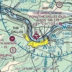
|
| Airport distance calculator |
|---|
|
|
| Sunrise and sunset |
|---|
|
Times for 26-Jul-2026
| | Local
(UTC-7) | | Zulu
(UTC) |
|---|
| Morning civil twilight | | 05:07 | | 12:07 |
| Sunrise | | 05:42 | | 12:42 |
| Sunset | | 20:40 | | 03:40 |
| Evening civil twilight | | 21:15 | | 04:15 |
|
| Current date and time |
|---|
| Zulu (UTC) | 26-Jul-2026 23:43:57 |
|---|
| Local (UTC-7) | 26-Jul-2026 16:43:57 |
|---|
|
| METAR |
|---|
| KDLS | 262253Z AUTO 28015KT 10SM SCT110 29/11 A2994 RMK AO2 SLP135 T02890106
|
K4S2
16nm W | 262315Z AUTO 31015G21KT 10SM CLR 26/11 A2998 RMK AO2
|
|
| TAF |
|---|
| KDLS | 261720Z 2618/2718 32010KT P6SM SKC FM262100 31015G24KT P6SM SKC FM270600 29011KT P6SM SCT250
|
|
| NOTAMs |
|---|
NOTAMs are issued by the DoD/FAA and will open in a separate window not controlled by AirNav.
|
|

