FAA INFORMATION EFFECTIVE 14 MAY 2026
Location
| FAA Identifier: | DPL |
| Lat/Long: | 35-00-00.1310N 077-58-53.9700W
35-00.002183N 077-58.899500W
35.0000364,-77.9816583
(estimated) |
| Elevation: | 136.6 ft. / 41.6 m (surveyed) |
| Variation: | 09W (2010) |
| From city: | 2 miles NW of KENANSVILLE, NC |
| Time zone: | UTC -4 (UTC -5 during Standard Time) |
| Zip code: | 28349 |
Airport Operations
| Airport use: | Open to the public |
| Activation date: | 08/1974 |
| Control tower: | no |
| ARTCC: | WASHINGTON CENTER |
| FSS: | RALEIGH FLIGHT SERVICE STATION |
| NOTAMs facility: | DPL (NOTAM-D service available) |
| Attendance: | SUN 1300-1800, ALL MON-FRI 0700-1800, ALL SAT 0800-1800
UNATTENDED THANKSGIVING AND CHRISTMAS. |
| Wind indicator: | lighted |
| Segmented circle: | yes |
| Lights: | ACTVT REIL RWY 05 & 23 - CTAF. MIRL RWY 05/23 ON UNTIL MIDNIGHT. AFTER MIDNIGHT, ACTVT MIRL RWY 05/23 - CTAF. |
| Beacon: | white-green (lighted land airport)
Operates sunset to sunrise. |
Airport Communications
| CTAF/UNICOM: | 123.0 |
| WX AWOS-3: | 120.675 (910-296-9688) |
| SEYMOUR JOHNSON APPROACH: | 119.7 |
| SEYMOUR JOHNSON DEPARTURE: | 119.7 |
| WX AWOS-3P at W40 (14 nm N): | 120.075 (919-658-8067) |
| WX AWOS-3P at ACZ (17 nm S): | 121.07 (910-285-0419) |
| WX AWOS-3 at CTZ (19 nm W): | 119.125 (910-592-7488) |
- APCH/DEP SVC PRVDD BY WASHINGTON ARTCC (ZDC) ON 123.85/279.65 (NEW BERN RCAG) WHEN APCH CTL CLSD.
Nearby radio navigation aids
| VOR radial/distance | | VOR name | | Freq | | Var |
|---|
| ISOr228/30.4 | | KINSTON VORTAC | | 117.50 | | 05W |
| ILMr359/39.3 | | WILMINGTON VORTAC | | 117.00 | | 07W |
| NDB name | | Hdg/Dist | | Freq | | Var | | ID |
|---|
| CLINTON | | 094/18.8 | | 412 | | 09W | | CTZ | -.-. - --.. |
Airport Services
| Fuel available: | 100LL JET-A1+
100LL:FUEL 24 HR CREDIT CARD SVC AVBL. |
| Parking: | tiedowns |
| Airframe service: | MAJOR |
| Powerplant service: | MAJOR |
| Bottled oxygen: | HIGH |
| Bulk oxygen: | NONE |
Runway Information
Runway 5/23
| Dimensions: | 6003 x 100 ft. / 1830 x 30 m |
| Surface: | asphalt, in excellent condition |
| Weight bearing capacity: | | Single wheel: | 70.0 | | Double wheel: | 95.0 |
|
| Runway edge lights: | medium intensity |
| RUNWAY 5 | | RUNWAY 23 |
| Latitude: | 34-59.603753N | | 35-00.400592N |
| Longitude: | 077-59.256085W | | 077-58.542858W |
| Elevation: | 134.9 ft. | | 136.6 ft. |
| Traffic pattern: | left | | left |
| Runway heading: | 045 magnetic, 036 true | | 225 magnetic, 216 true |
| Markings: | precision, in good condition | | precision, in good condition |
| Visual slope indicator: | 4-light PAPI on left (3.00 degrees glide path) | | 4-light PAPI on left (3.00 degrees glide path) |
| Runway end identifier lights: | yes | | yes |
| Touchdown point: | yes, no lights | | yes, no lights |
| Instrument approach: | | | LOCALIZER |
| Obstructions: | 8 ft. brush, 325 ft. from runway, 212 ft. right of centerline, 15:1 slope to clear | | 41 ft. trees, 1283 ft. from runway, 153 ft. left of centerline, 26:1 slope to clear |
Airport Ownership and Management from official FAA records
| Ownership: | Publicly-owned |
| Owner: | DUPLIN COUNTY
260 AIRPORT ROAD
KENANSVILLE, NC 28349
Phone 910-296-2188 |
| Manager: | JOSH RAYNOR
260 AIRPORT ROAD
KENANSVILLE, NC 28349
Phone 910-296-2188 |
Additional Remarks
| - | DEER/DOGS/BIRDS ON & INVOF ARPT. |
| - | MIL ACFT LAND FORWARD OF NUMBERS AND LIMIT DELAY ON RWY TO AVOID DAMAGE TO RWY SURFACES. |
| - | NOISE ABATEMENT PROCEDURES IN EFFECT, CALL AMGR 910-296-2188. |
| - | DUPLIN CO ARPT CLSD TO TOUCH & GO/PRACTICE APPROACHES 2100-0600 LCL DLY. (ALL OTHER TIMES T&G/PRACTICE APPROACHES LIMITED TO 30 MINUTES EACH). |
| - | ARPT CLSD TO MIL ACFT EXCEPT 1 HR PPR. |
| - | CD CTC SEYMOUR JOHNSON APCH AT 919-722-4186. |
Instrument Procedures
NOTE: All procedures below are presented as PDF files. If you need a reader for these files, you should download the free Adobe Reader.NOT FOR NAVIGATION. Please procure official charts for flight.
FAA instrument procedures published for use from 14 May 2026 at 0901Z to 11 June 2026 at 0900Z.
IAPs - Instrument Approach Procedures |
|---|
| RNAV (GPS) RWY 05 | |
download (220KB) |
| RNAV (GPS) RWY 23 | |
download (184KB) |
| NOTE: Special Alternate Minimums apply | |
download (24KB) |
| NOTE: Special Take-Off Minimums/Departure Procedures apply | |
download (387KB) |
Other nearby airports with instrument procedures:
W40 - Mount Olive Municipal Airport (14 nm N)
KACZ - Wallace-Pender Airport (17 nm S)
KCTZ - Clinton-Sampson County Airport (19 nm W)
KGSB - Seymour Johnson Air Force Base (20 nm N)
KOAJ - Albert J Ellis Airport (21 nm SE)
|
|

Road maps at:
MapQuest
Bing
Google
| Aerial photo |
|---|
WARNING: Photo may not be current or correct
 Photo taken 29-Sep-2008
Do you have a better or more recent aerial photo of Duplin County Airport that you would like to share? If so, please send us your photo.
|
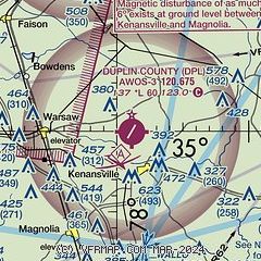
| Sectional chart |
|---|
|
| Airport distance calculator |
|---|
|
|
| Sunrise and sunset |
|---|
|
Times for 17-May-2026
| | Local
(UTC-4) | | Zulu
(UTC) |
|---|
| Morning civil twilight | | 05:40 | | 09:40 |
| Sunrise | | 06:08 | | 10:08 |
| Sunset | | 20:09 | | 00:09 |
| Evening civil twilight | | 20:37 | | 00:37 |
|
| Current date and time |
|---|
| Zulu (UTC) | 17-May-2026 08:16:10 |
|---|
| Local (UTC-4) | 17-May-2026 04:16:10 |
|---|
|
| METAR |
|---|
| KDPL | 170755Z AUTO 00000KT 10SM CLR 15/14 A3014 RMK AO2
|
KACZ
16nm S | 170755Z AUTO 00000KT 10SM CLR 14/13 A3013 RMK AO2 T01380134
|
KCTZ
19nm W | 170755Z AUTO 00000KT 10SM CLR 16/16 A3014 RMK AO2 T01600160
|
KGSB
19nm N | 170555Z AUTO 19003KT 10SM FEW210 M M RMK AO2 SLPNO RVRNO TSNO $
|
|
| TAF |
|---|
KOAJ
21nm SE | 170520Z 1706/1806 20005KT P6SM FEW200 FM171300 24007KT P6SM FEW200 FM172000 18009G16KT P6SM FEW150 FM180000 18005KT P6SM SKC FM180400 VRB02KT P6SM FEW020 AMD LTD TO CLD VIS AND WIND
|
|
| NOTAMs |
|---|
NOTAMs are issued by the DoD/FAA and will open in a separate window not controlled by AirNav.
|
|


