FAA INFORMATION EFFECTIVE 14 MAY 2026
Location
| FAA Identifier: | DSV |
| Lat/Long: | 42-34-13.9130N 077-42-47.7820W
42-34.231883N 077-42.796367W
42.5705314,-77.7132728
(estimated) |
| Elevation: | 659.8 ft. / 201.1 m (surveyed) |
| Variation: | 09W (1975) |
| From city: | 1 mile NW of DANSVILLE, NY |
| Time zone: | UTC -4 (UTC -5 during Standard Time) |
| Zip code: | 14437 |
Airport Operations
| Airport use: | Open to the public |
| Activation date: | 04/1941 |
| Control tower: | no |
| ARTCC: | CLEVELAND CENTER |
| FSS: | BUFFALO FLIGHT SERVICE STATION |
| NOTAMs facility: | DSV (NOTAM-D service available) |
| Attendance: | MON - FRI 0900-1630 |
| Wind indicator: | lighted |
| Segmented circle: | yes |
| Lights: | ACTVT VASI RWY 14 & 32; MIRL RWY 14/32 - CTAF. |
| Beacon: | white-green (lighted land airport)
Operates sunset to sunrise. |
Airport Communications
| CTAF/UNICOM: | 123.0 |
| WX ASOS: | 118.325 (585-335-2380) |
| ROCHESTER APPROACH: | 123.7 |
| ROCHESTER DEPARTURE: | 123.7 |
| WX AWOS-3 at HTF (11 nm S): | 118.475 (607-324-9138) |
| WX AWOS-2 at 01G (18 nm NW): | 118.525 (585-237-0235) |
Nearby radio navigation aids
| VOR radial/distance | | VOR name | | Freq | | Var |
|---|
| GEEr186/15.9 | | GENESEO VOR/DME | | 108.20 | | 09W |
| ROCr195/32.9 | | ROCHESTER VOR/DME | | 110.00 | | 12W |
Airport Services
| Fuel available: | 100LL
100LL:24 HR SELF SVC. |
| Parking: | hangars and tiedowns |
| Airframe service: | NONE |
| Powerplant service: | NONE |
| Bottled oxygen: | NONE |
| Bulk oxygen: | NONE |
Runway Information
Runway 14/32
| Dimensions: | 3500 x 100 ft. / 1067 x 30 m |
| Surface: | asphalt, in good condition |
| Weight bearing capacity: | | Single wheel: | 30.0 | | Double wheel: | MIN SFC AND BASE REQRMTS NOT MET FOR DUAL AND DUAL TANDEM GWTS RWY 14-32. |
|
| Runway edge lights: | medium intensity |
| RUNWAY 14 | | RUNWAY 32 |
| Latitude: | 42-34.409938N | | 42-34.053827N |
| Longitude: | 077-43.102733W | | 077-42.490032W |
| Elevation: | 635.3 ft. | | 659.8 ft. |
| Traffic pattern: | left | | left |
| Runway heading: | 137 magnetic, 128 true | | 317 magnetic, 308 true |
| Markings: | basic, in fair condition | | basic, in fair condition |
| Visual slope indicator: | 2-box VASI on left (3.00 degrees glide path) | | 4-box VASI on left (4.00 degrees glide path) |
| Runway end identifier lights: | no | | no |
| Touchdown point: | yes, no lights | | yes, no lights |
| Obstructions: | 6 ft. fence, lighted, 215 ft. from runway, 250 ft. right of centerline, 2:1 slope to clear
4 FT FENCE & 40 FT TREES IN THE APCH. | | 15 ft. road, 201 ft. from runway, 200 ft. right of centerline
ACES ROAD W/FENCE 230 FT RIGHT. |
Airport Ownership and Management from official FAA records
| Ownership: | Publicly-owned |
| Owner: | TOWN OF NORTH DANSVILLE
TOWN HALL, 14 CLARA BARTON ST
DANSVILLE, NY 14437
Phone 585-335-2330 |
| Manager: | RICK LAFFORD
176 FRANKLIN STREET
DANSVILLE, NY 14437
Phone 585-451-3316
AMGR CELL 585-451-3316 |
Additional Remarks
| - | EXTSV GLIDER ACTVTY. GLIDER USE RIGHT PAT FOR THE TURF AREA RIGHT OF RWY 32 & LEFT PAT FOR THE TURF AREA LEFT OF RWY 14. |
| - | FOR CD CTC CLEVELAND ARTCC AT 440-774-0490. |
| - | RWY 14 90 FT RELCTD THLD. |
Instrument Procedures
NOTE: All procedures below are presented as PDF files. If you need a reader for these files, you should download the free Adobe Reader.NOT FOR NAVIGATION. Please procure official charts for flight.
FAA instrument procedures published for use from 14 May 2026 at 0901Z to 11 June 2026 at 0900Z.
IAPs - Instrument Approach Procedures |
|---|
| RNAV (GPS) RWY 14 | |
download (205KB) |
| RNAV (GPS)-A | |
download (157KB) |
| NOTE: Special Alternate Minimums apply | |
download (122KB) |
| NOTE: Special Take-Off Minimums/Departure Procedures apply | |
download (458KB) |
Other nearby airports with instrument procedures:
KHTF - Hornell Municipal Airport (11 nm S)
5G0 - Le Roy Airport (27 nm N)
KIUA - Canandaigua Airport (27 nm NE)
KPEO - Penn Yan/Yates County Airport (29 nm E)
KELZ - Wellsville Municipal Airport/Tarantine Field (30 nm SW)
|
|

Road maps at:
MapQuest
Bing
Google
| Aerial photo |
|---|
WARNING: Photo may not be current or correct
 Photo courtesy of Ted Timmons, CFII-G
Taken in June 2017
looking south.
Photo courtesy of Ted Timmons, CFII-G
Taken in June 2017
looking south.
Do you have a better or more recent aerial photo of Dansville Municipal Airport that you would like to share? If so, please send us your photo.
|
| Sectional chart |
|---|
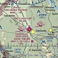
|
| Airport distance calculator |
|---|
|
|
| Sunrise and sunset |
|---|
|
Times for 01-Jun-2026
| | Local
(UTC-4) | | Zulu
(UTC) |
|---|
| Morning civil twilight | | 05:03 | | 09:03 |
| Sunrise | | 05:37 | | 09:37 |
| Sunset | | 20:40 | | 00:40 |
| Evening civil twilight | | 21:15 | | 01:15 |
|
| Current date and time |
|---|
| Zulu (UTC) | 01-Jun-2026 04:40:59 |
|---|
| Local (UTC-4) | 01-Jun-2026 00:40:59 |
|---|
|
| METAR |
|---|
| KDSV | 010354Z AUTO 18003KT 10SM FEW085 12/07 A2997 RMK AO2 SLP155 T01220072 $
|
|
| TAF |
|---|
KROC
33nm N | 311721Z 3118/0118 32013G22KT P6SM FEW250 FM312300 28009KT P6SM FEW250 FM010300 28005KT P6SM BKN080 FM010600 VRB04KT P6SM SCT090 FM011400 02005KT P6SM FEW250 FM011700 03007KT P6SM SKC
|
|
| NOTAMs |
|---|
NOTAMs are issued by the DoD/FAA and will open in a separate window not controlled by AirNav.
|
|

