FAA INFORMATION EFFECTIVE 19 FEBRUARY 2026
Location
| FAA Identifier: | ELZ |
| Lat/Long: | 42-06-34.2860N 077-59-23.9230W
42-06.571433N 077-59.398717W
42.1095239,-77.9899786
(estimated) |
| Elevation: | 2124.5 ft. / 647.5 m (surveyed) |
| Variation: | 08W (1965) |
| From city: | 2 miles SW of WELLSVILLE, NY |
| Time zone: | UTC -5 (UTC -4 during Daylight Saving Time) |
| Zip code: | 14895 |
Airport Operations
| Airport use: | Open to the public |
| Activation date: | 11/1970 |
| Control tower: | no |
| ARTCC: | CLEVELAND CENTER |
| FSS: | BUFFALO FLIGHT SERVICE STATION |
| NOTAMs facility: | ELZ (NOTAM-D service available) |
| Attendance: | MON-FRI 0800-1630
UNATNDD WKENDS, MEMORIAL DAY, 4TH OF JULY, LABOR DAY, THANKSGIVING, CHRISTMAS EVE, CHRISTMAS & NEW YEARS DAY.
AFT HRS SVCS AVBL CALL 585-593-3350 FOR NUMBERS. 24 HR ACCESS TO THE LOBBY AND RESTROOMS. 24 HR SELF SERVE AVGAS AND JET-A. |
| Wind indicator: | lighted |
| Segmented circle: | no |
| Lights: | ACTVT MALS RWY 28; REIL RWY 10; PAPI RWY 10 & 28; HIRL RWY 10/28 - CTAF. |
| Beacon: | white-green (lighted land airport)
BCN ON DUSK-DAWN DLY. |
| Landing fee: | yes |
Airport Communications
| CTAF/UNICOM: | 123.0 |
| WX ASOS: | 119.275 (585-593-0203) |
| WX AWOS-3 at OLE (19 nm NW): | 118.375 (716-557-2001) |
- APCH/DEP SVC PRVDD BY CLEVELAND ARTCC ON FREQS 124.325/353.850 (WAYLAND RCAG).
Nearby radio navigation aids
| VOR radial/distance | | VOR name | | Freq | | Var |
|---|
| SFKr322/35.6 | | STONYFORK VOR/DME | | 108.60 | | 08W |
| SLTr007/35.8 | | SLATE RUN VORTAC | | 113.90 | | 08W |
Airport Services
| Fuel available: | 100LL JET-A |
| Parking: | hangars and tiedowns |
| Airframe service: | MAJOR |
| Powerplant service: | MAJOR |
| Bottled oxygen: | NONE |
| Bulk oxygen: | NONE |
Runway Information
Runway 10/28
| Dimensions: | 5300 x 100 ft. / 1615 x 30 m |
| Surface: | asphalt/grooved, in good condition |
| Weight bearing capacity: | | Single wheel: | 25.0 | | Double wheel: | 45.0 |
|
| Runway edge lights: | high intensity |
| RUNWAY 10 | | RUNWAY 28 |
| Latitude: | 42-06.566007N | | 42-06.576810N |
| Longitude: | 077-59.984582W | | 077-58.812842W |
| Elevation: | 2122.6 ft. | | 2099.9 ft. |
| Traffic pattern: | left | | left |
| Runway heading: | 097 magnetic, 089 true | | 277 magnetic, 269 true |
| Displaced threshold: | 200 ft. | | no |
| Markings: | precision, in fair condition | | precision, in fair condition |
| Visual slope indicator: | 2-light PAPI on left (3.00 degrees glide path)
PAPI UNUSBL BYD 9 DEGS RIGHT AND LEFT OF CNTRLN. | | 2-light PAPI on left (3.00 degrees glide path) |
| Approach lights: | | | MALS: 1,400 foot medium intensity approach lighting system |
| Runway end identifier lights: | yes | | |
| Touchdown point: | yes, no lights | | yes, no lights |
| Instrument approach: | | | LOCALIZER |
| Obstructions: | 43 ft. trees, 631 ft. from runway, 442 ft. right of centerline, 10:1 slope to clear
15 FT ROAD AND 9 FT FENCE 250 - 460 FT RIGHT. | | 45 ft. tree, 1241 ft. from runway, 400 ft. left of centerline, 23:1 slope to clear |
Airport Ownership and Management from official FAA records
| Ownership: | Publicly-owned |
| Owner: | TOWN OF WELLSVILLE
MUNI BLDG
WELLSVILLE, NY 14895
Phone 585-593-1780 |
| Manager: | WILLIS SHUTT
2600 TARANTINE RD.
WELLSVILLE, NY 14895
Phone 585-593-3350
FAX: 585-593-1543 |
Additional Remarks
| E25 | BASED ON AN ULTIMATE LENGTH OF 5700 FT. |
| - | FOR CD CTC CLEVELAND ARTCC AT 440-774-0227. |
| - | PILOTS CONDUCTING EFVS OPS; BE AWARE LED ALS IN USE RWY 28. |
Instrument Procedures
NOTE: All procedures below are presented as PDF files. If you need a reader for these files, you should download the free Adobe Reader.NOT FOR NAVIGATION. Please procure official charts for flight.
FAA instrument procedures published for use from 19 February 2026 at 0901Z to 19 March 2026 at 0900Z.
IAPs - Instrument Approach Procedures |
|---|
| RNAV (GPS) RWY 10 **CHANGED** | |
download (185KB) |
| RNAV (GPS) RWY 28 **CHANGED** | |
download (189KB) |
| NOTE: Special Alternate Minimums apply | |
download (122KB) |
| NOTE: Special Take-Off Minimums/Departure Procedures apply | |
download (442KB) |
Other nearby airports with instrument procedures:
KOLE - Cattaraugus County-Olean Airport (19 nm NW)
KHTF - Hornell Municipal Airport (21 nm NE)
KDSV - Dansville Municipal Airport (30 nm NE)
KBFD - Bradford Regional Airport (34 nm SW)
N38 - Grand Canyon Regional Airport (35 nm SE)
|
|

Road maps at:
MapQuest
Bing
Google
| Aerial photo |
|---|
WARNING: Photo may not be current or correct
 Photo by Carol Rader
Taken mid March 2009
Photo by Carol Rader
Taken mid March 2009
Do you have a better or more recent aerial photo of Wellsville Municipal Airport/Tarantine Field that you would like to share? If so, please send us your photo.
|
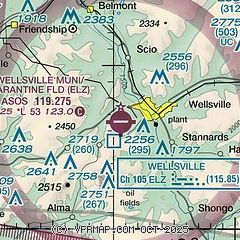
| Sectional chart |
|---|
|
| Airport distance calculator |
|---|
|
|
| Sunrise and sunset |
|---|
|
Times for 28-Feb-2026
| | Local
(UTC-5) | | Zulu
(UTC) |
|---|
| Morning civil twilight | | 06:22 | | 11:22 |
| Sunrise | | 06:50 | | 11:50 |
| Sunset | | 17:59 | | 22:59 |
| Evening civil twilight | | 18:27 | | 23:27 |
|
| Current date and time |
|---|
| Zulu (UTC) | 28-Feb-2026 19:49:36 |
|---|
| Local (UTC-5) | 28-Feb-2026 14:49:36 |
|---|
|
| METAR |
|---|
| KELZ | 281856Z AUTO 30012G18KT 10SM CLR 10/M05 A2997 RMK AO2 SLP159 T01001050 $
|
KOLE
18nm NW | 281935Z AUTO 28003KT 10SM CLR 06/M02 A2999 RMK AO2
|
|
| TAF |
|---|
KBFD
34nm SW | 281740Z 2818/0118 29012G20KT P6SM SKC FM281900 30010G17KT P6SM BKN250 FM282100 31008G15KT P6SM BKN030 BKN070 TEMPO 0103/0105 02008KT 3SM -SN SCT025 OVC035 FM010500 02009KT 2SM -SN OVC018 FM011500 35010KT P6SM BKN050
|
|
| NOTAMs |
|---|
NOTAMs are issued by the DoD/FAA and will open in a separate window not controlled by AirNav.
|
|

