FAA INFORMATION EFFECTIVE 14 MAY 2026
Location
| FAA Identifier: | N38 |
| Lat/Long: | 41-43-40.7618N 077-23-43.5751W
41-43.679363N 077-23.726252W
41.7279894,-77.3954375
(estimated) |
| Elevation: | 1891.5 ft. / 576.5 m (surveyed) |
| Variation: | 11W (2000) |
| From city: | 4 miles SW of WELLSBORO, PA |
| Time zone: | UTC -4 (UTC -5 during Standard Time) |
| Zip code: | 16901 |
Airport Operations
| Airport use: | Open to the public |
| Activation date: | 03/1947 |
| Control tower: | no |
| ARTCC: | NEW YORK CENTER |
| FSS: | WILLIAMSPORT FLIGHT SERVICE STATION |
| NOTAMs facility: | IPT (NOTAM-D service available) |
| Attendance: | MON-FRI 1000-1500, ALL SAT-SUN UNATT |
| Wind indicator: | lighted |
| Segmented circle: | no |
| Lights: | ACTVT REIL RWY 28; MIRL 10/28 - CTAF. |
| Beacon: | white-green (lighted land airport)
Operates sunset to sunrise. |
Airport Communications
| CTAF/UNICOM: | 122.8 |
| WX AWOS-3PT: | 120.925 (570-723-0385) |
| ELMIRA APPROACH: | 128.425 |
| ELMIRA DEPARTURE: | 128.425 |
- APCH/DEP SVC PRVDD BY NEW YORK ARTCC ON FREQS 133.35/372.0 (SAYRE RCAG) WHEN ELMIRA APCH CTL CLSD.
Nearby radio navigation aids
| VOR radial/distance | | VOR name | | Freq | | Var |
|---|
| SFKr037/2.2 | | STONYFORK VOR/DME | | 108.60 | | 08W |
| SLTr071/28.8 | | SLATE RUN VORTAC | | 113.90 | | 08W |
| FQMr319/36.4 | | WILLIAMSPORT VOR/DME | | 114.40 | | 09W |
Airport Services
| Fuel available: | 100LL JET-A |
| Parking: | hangars and tiedowns |
| Airframe service: | NONE |
| Powerplant service: | NONE |
| Bottled oxygen: | NONE |
| Bulk oxygen: | NONE |
Runway Information
Runway 10/28
| Dimensions: | 3597 x 60 ft. / 1096 x 18 m |
| Surface: | asphalt, in fair condition |
| Runway edge lights: | medium intensity |
| RUNWAY 10 | | RUNWAY 28 |
| Latitude: | 41-43.661790N | | 41-43.683742N |
| Longitude: | 077-24.185672W | | 077-23.395735W |
| Elevation: | 1889.3 ft. | | 1881.1 ft. |
| Traffic pattern: | left | | left |
| Runway heading: | 099 magnetic, 088 true | | 279 magnetic, 268 true |
| Markings: | nonprecision, in fair condition | | nonprecision, in fair condition |
| Runway end identifier lights: | no | | yes |
| Touchdown point: | yes, no lights | | yes, no lights |
| Obstructions: | 45 ft. trees, 582 ft. from runway, 298 ft. right of centerline, 8:1 slope to clear | | none |
Runway 11/29
| Dimensions: | 1576 x 80 ft. / 480 x 24 m |
| Surface: | turf, in good condition |
| RUNWAY 11 | | RUNWAY 29 |
| Latitude: | 41-43.687763N | | 41-43.698710N |
| Longitude: | 077-23.752578W | | 077-23.406532W |
| Elevation: | 1886.8 ft. | | 1877.9 ft. |
| Traffic pattern: | left | | left |
| Runway heading: | 099 magnetic, 088 true | | 279 magnetic, 268 true |
| Touchdown point: | yes, no lights | | yes, no lights |
Airport Ownership and Management from official FAA records
| Ownership: | Publicly-owned |
| Owner: | GRAND CANYON ARPT AUTH
112 RUNWAY RD
WELLSBORO, PA 16901
Phone (570) 724-3746 |
| Manager: | SHAW SIGLIN
112 RUNWAY ROAD
WELLSBORO, PA 16901
Phone (570) 724-3746
(570) 439-8103 |
Additional Remarks
| - | TURF RWY 11/29 1600 FT X 100 FT DAY VFR ONLY; NON SIMULTANEOUS OPS; CLSD ANNUALLY DEC-APR. |
| - | FOR CD CTC NEW YORK ARTCC AT 631-468-1425. |
Instrument Procedures
NOTE: All procedures below are presented as PDF files. If you need a reader for these files, you should download the free Adobe Reader.NOT FOR NAVIGATION. Please procure official charts for flight.
FAA instrument procedures published for use from 14 May 2026 at 0901Z to 11 June 2026 at 0900Z.
IAPs - Instrument Approach Procedures |
|---|
| RNAV (GPS) RWY 10 **CHANGED** | |
download (220KB) |
| RNAV (GPS) RWY 28 **CHANGED** | |
download (219KB) |
| NOTE: Special Alternate Minimums apply **CHANGED** | |
download (145KB) |
| NOTE: Special Take-Off Minimums/Departure Procedures apply | |
download (432KB) |
Other nearby airports with instrument procedures:
KELM - Elmira/Corning Regional Airport (34 nm NE)
KELZ - Wellsville Municipal Airport/Tarantine Field (35 nm NW)
KLHV - William T Piper Memorial Airport (36 nm S)
KIPT - Williamsport Regional Airport (36 nm SE)
KHTF - Hornell Municipal Airport (41 nm N)
|
|

Road maps at:
MapQuest
Bing
Google
| Aerial photo |
|---|
WARNING: Photo may not be current or correct
 Photo taken 22-Oct-2015
looking east.
Photo taken 22-Oct-2015
looking east.
Do you have a better or more recent aerial photo of Grand Canyon Regional Airport that you would like to share? If so, please send us your photo.
|
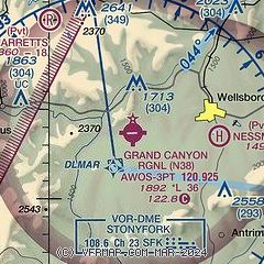
| Sectional chart |
|---|
|
| Airport distance calculator |
|---|
|
|
| Sunrise and sunset |
|---|
|
Times for 02-Jun-2026
| | Local
(UTC-4) | | Zulu
(UTC) |
|---|
| Morning civil twilight | | 05:04 | | 09:04 |
| Sunrise | | 05:38 | | 09:38 |
| Sunset | | 20:37 | | 00:37 |
| Evening civil twilight | | 21:11 | | 01:11 |
|
| Current date and time |
|---|
| Zulu (UTC) | 03-Jun-2026 01:31:26 |
|---|
| Local (UTC-4) | 02-Jun-2026 21:31:26 |
|---|
|
| METAR |
|---|
| KN38 | 030115Z AUTO 36005KT 10SM CLR 15/03 A3025 RMK AO2
|
|
| TAF |
|---|
KELM
34nm NE | 021720Z 0218/0318 02007G15KT P6SM FEW060 FM030000 00000KT P6SM FEW180
|
KIPT
36nm SE | 022217Z 0222/0318 35008G15KT P6SM FEW090 FM030100 29004KT P6SM SCT250 FM030700 29002KT P6SM BKN250 FM031400 32005KT P6SM SKC
|
|
| NOTAMs |
|---|
NOTAMs are issued by the DoD/FAA and will open in a separate window not controlled by AirNav.
|
|

