FAA INFORMATION EFFECTIVE 14 MAY 2026
Location
| FAA Identifier: | DTG |
| Lat/Long: | 41-07-57.4385N 088-26-19.1230W
41-07.957308N 088-26.318717W
41.1326218,-88.4386453
(estimated) |
| Elevation: | 632 ft. / 193 m (estimated) |
| Variation: | 02W (2000) |
| From city: | 3 miles N of DWIGHT, IL |
| Time zone: | UTC -5 (UTC -6 during Standard Time) |
| Zip code: | 60420 |
Airport Operations
| Airport use: | Open to the public |
| Activation date: | 04/1962 |
| Control tower: | no |
| ARTCC: | CHICAGO CENTER |
| FSS: | KANKAKEE FLIGHT SERVICE STATION |
| NOTAMs facility: | IKK (NOTAM-D service available) |
| Attendance: | UNATNDD |
| Pattern altitude: | 1432 ft. MSL |
| Wind indicator: | yes |
| Segmented circle: | no |
| Lights: | FOR LIRL RY 09/27 AFTER 2200 CALL 815-258-8218. |
| Beacon: | white-green (lighted land airport)
FOR ROTG BCN CALL 815-258-8218. |
Airport Communications
| CTAF/UNICOM: | 122.8 |
| WX AWOS-3 at PNT (15 nm SW): | 119.675 (815-844-0923) |
| WX AWOS-3 at C09 (18 nm N): | 118.175 (815-941-1815) |
- APCH/DEP SVC PRVDD BY CHICAGO ARTCC (ZAU) ON FREQS 123.75/259.1 (MAZON RCAG).
Nearby radio navigation aids
| VOR radial/distance | | VOR name | | Freq | | Var |
|---|
| JOTr190/25.4 | | JOLIET VOR/DME | | 112.30 | | 02E |
| EONr252/30.4 | | PEOTONE VORTAC | | 113.20 | | 02E |
| RBSr337/35.3 | | ROBERTS VOR/DME | | 116.80 | | 02E |
Airport Services
| Fuel available: | 100LL |
| Parking: | hangars and tiedowns |
Runway Information
Runway 9/27
| Dimensions: | 2364 x 21 ft. / 721 x 6 m
21' ASPH STRIP CENTERED ON 100' TURF STRIP. |
| Surface: | asphalt/turf, in good condition |
| Runway edge lights: | non-standard
RY 09/27 NSTD LIRL; NOT FAA APPROVED L-800 SERIES. SPACING & INTST OF LGTS VARY. |
| Runway edge markings: | 09/27 NSTD MKGS DUE TO NARROW WIDTH. |
| RUNWAY 9 | | RUNWAY 27 |
| Latitude: | 41-07.950550N | | 41-07.964067N |
| Longitude: | 088-26.576017W | | 088-26.061417W |
| Elevation: | 629.0 ft. | | 623.0 ft. |
| Traffic pattern: | left | | left |
| Runway heading: | 090 magnetic, 088 true | | 270 magnetic, 268 true |
| Displaced threshold: | no | | 300 ft. |
| Markings: | NSTD, in good condition | | NSTD, in good condition |
| Runway end identifier lights: | no | | |
| Touchdown point: | yes, no lights | | yes, no lights |
| Obstructions: | 8 ft. crops, 200 ft. from runway
RWY 09, 8 FT CROP 100 FT FM END OF RWY, OB CNTRLN, 12 TO 1. | | 15 ft. road, 200 ft. from runway, 180 ft. right of centerline
RWY 27 15 FT RD 185 FT FM RY END 0B CNTRLN. |
Runway 18/36
| Dimensions: | 1900 x 100 ft. / 579 x 30 m |
| Surface: | turf, in good condition |
| RUNWAY 18 | | RUNWAY 36 |
| Traffic pattern: | left | | left |
| Markings: | none | | none |
| Runway end identifier lights: | no | | no |
| Obstructions: | 8 ft. crops, 50 ft. from runway, 6:1 slope to clear | | 8 ft. crops, 50 ft. from runway, 6:1 slope to clear |
Airport Ownership and Management from official FAA records
| Ownership: | Privately-owned |
| Owner: | DWIGHT AERO SERVICE
6034 E CAMBRIDGE AVENUE
SCOTTSDALE, AZ 85257
Phone (602) 319-3319 |
| Manager: | DAN RIBORDY
PO BOX 214
DWIGHT, IL 60420
Phone (815) 374-4319
EMAIL ADDRESS: DTGAERO@GMAIL.COM (ALL LOWER CASE) |
Additional Remarks
| - | FOR CD CTC CHICAGO ARTCC AT 630-906-8921. |
Instrument Procedures
There are no published instrument procedures at KDTG.
Some nearby airports with instrument procedures:
KPNT - Pontiac Municipal Airport (15 nm SW)
C09 - Morris Municipal Airport/James R Washburn Field (18 nm N)
KIKK - Greater Kankakee Airport (27 nm E)
KLOT - Lewis University Airport (32 nm NE)
KVYS - Illinois Valley Regional Airport-Walter A Duncan Field (35 nm W)
|
|

Road maps at:
MapQuest
Bing
Google
| Aerial photo |
|---|
WARNING: Photo may not be current or correct
 Photo by Roger Kellogg
Photo taken 15-Apr-2007
Photo by Roger Kellogg
Photo taken 15-Apr-2007
Do you have a better or more recent aerial photo of Dwight Airport that you would like to share? If so, please send us your photo.
|
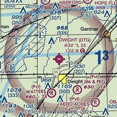
| Sectional chart |
|---|
|
| Airport distance calculator |
|---|
|
|
| Sunrise and sunset |
|---|
|
Times for 22-May-2026
| | Local
(UTC-5) | | Zulu
(UTC) |
|---|
| Morning civil twilight | | 04:58 | | 09:58 |
| Sunrise | | 05:30 | | 10:30 |
| Sunset | | 20:10 | | 01:10 |
| Evening civil twilight | | 20:42 | | 01:42 |
|
| Current date and time |
|---|
| Zulu (UTC) | 23-May-2026 04:38:53 |
|---|
| Local (UTC-5) | 22-May-2026 23:38:53 |
|---|
|
| METAR |
|---|
KPNT
16nm SW | 230415Z 10SM BKN029 OVC110 17/12 A2996 RMK AO2 T01680119
|
KC09
18nm N | 230402Z AUTO 09009KT 10SM SCT032 BKN041 OVC080 18/11 A2996 RMK AO2
|
KJOT
26nm NE | 230415Z AUTO 09007KT 10SM BKN036 OVC047 19/11 A2997 RMK AO2 T01860111
|
KIKK
27nm E | 230415Z AUTO 09010KT 10SM OVC026 16/11 A2998 RMK AO2 T01630110
|
|
| TAF |
|---|
KBMI
45nm SW | 230157Z 2302/2324 08009KT P6SM SCT025 OVC040 FM230500 VRB06KT P6SM OVC015 FM231700 29008KT P6SM BKN035
|
KDPA
48nm N | 230256Z 2303/2324 08010KT P6SM BKN050 OVC080 FM230900 03006KT P6SM SCT007 BKN020 TEMPO 2312/2315 5SM BR BKN009 OVC015 FM231800 29007KT P6SM SCT030 BKN050
|
KMDW
50nm NE | 230256Z 2303/2406 10010KT P6SM BKN035 OVC050 TEMPO 2304/2306 BKN025 FM230600 09008KT P6SM OVC020 FM230900 06007KT P6SM SCT007 OVC015 TEMPO 2311/2315 6SM BR BKN007 FM231700 01005KT P6SM BKN025 FM232000 05010KT P6SM SCT030 BKN050
|
|
| NOTAMs |
|---|
NOTAMs are issued by the DoD/FAA and will open in a separate window not controlled by AirNav.
|
|

