FAA INFORMATION EFFECTIVE 19 MARCH 2026
Location
| FAA Identifier: | DPA |
| Lat/Long: | 41-54-25.3910N 088-14-52.7820W
41-54.423183N 088-14.879700W
41.9070531,-88.2479950
(estimated) |
| Elevation: | 758.5 ft. / 231.2 m (surveyed) |
| Variation: | 01W (1985) |
| From city: | 29 miles W of central business district of the associated city |
| Time zone: | UTC -5 (UTC -6 during Standard Time) |
| Zip code: | 60185 |
Airport Operations
| Airport use: | Open to the public |
| Activation date: | 03/1943 |
| Control tower: | yes |
| ARTCC: | CHICAGO CENTER |
| FSS: | KANKAKEE FLIGHT SERVICE STATION |
| NOTAMs facility: | DPA (NOTAM-D service available) |
| Attendance: | CONTINUOUS |
| Wind indicator: | lighted |
| Segmented circle: | no |
| Lights: | ATC-CTL |
| Beacon: | white-green (lighted land airport) |
| International operations: | US CUSTOMS USER FEE ARPT. |
Airport Communications
| UNICOM: | 122.95 |
| ATIS: | 132.075 |
| WX ASOS: | PHONE 630-587-3668 |
| DUPAGE GROUND: | 121.8 |
| DUPAGE TOWER: | 120.9 257.8 124.5 |
| CHICAGO APPROACH: | 133.5 |
| CHICAGO DEPARTURE: | 133.5 |
| CLEARANCE DELIVERY: | 119.75 |
| WX AWOS-3 at 06C (8 nm NE): | 128.275 ((847) 895-2887) |
| WX ASOS at ARR (13 nm SW): | PHONE 630-466-5649 |
| WX ASOS at ORD (16 nm E): | PHONE 773-800-0035 |
| WX AWOS-3PT at LOT (19 nm S): | 126.675 (815-588-4802) |
| WX ASOS at PWK (20 nm NE): | PHONE 847-465-0291 |
Nearby radio navigation aids
| VOR radial/distance | | VOR name | | Freq | | Var |
|---|
| DPAr076/4.7 | | DUPAGE VOR/DME | | 114.55 | | 02E |
| JOTr006/21.9 | | JOLIET VOR/DME | | 112.30 | | 02E |
| OBKr217/23.0 | | NORTHBROOK VOR/DME | | 113.00 | | 02W |
| CGTr306/38.5 | | CHICAGO HEIGHTS VORTAC | | 114.20 | | 02E |
Airport Services
| Fuel available: | 100LL JET-A
100LL:100LL SELF SER AVBL 24HR WITH CREDIT CARD. |
| Parking: | hangars and tiedowns |
| Airframe service: | MAJOR |
| Powerplant service: | MAJOR |
| Bottled oxygen: | HIGH/LOW |
| Bulk oxygen: | HIGH/LOW |
Runway Information
Runway 2L/20R
| Dimensions: | 7571 x 150 ft. / 2308 x 46 m |
| Surface: | concrete/grooved, in good condition |
| Weight bearing capacity: | | Single wheel: | 30.0 | | Double wheel: | 45.0 |
|
| Runway edge lights: | high intensity |
| RUNWAY 2L | | RUNWAY 20R |
| Latitude: | 41-53.641832N | | 41-54.851250N |
| Longitude: | 088-15.212758W | | 088-14.808688W |
| Elevation: | 750.8 ft. | | 755.5 ft. |
| Traffic pattern: | left | | left |
| Runway heading: | 015 magnetic, 014 true | | 195 magnetic, 194 true |
| Markings: | precision, in good condition | | precision, in good condition |
| Visual slope indicator: | | | 4-light PAPI on left (3.00 degrees glide path) |
| RVR equipment: | touchdown | | rollout |
| Approach lights: | MALSR: 1,400 foot medium intensity approach lighting system with runway alignment indicator lights | | |
| Centerline lights: | yes | | yes |
| Touchdown point: | yes, lighted | | yes, no lights |
| Instrument approach: | ILS | | |
Runway 2R/20L
| Dimensions: | 6451 x 100 ft. / 1966 x 30 m |
| Surface: | concrete/grooved, in good condition |
| Weight bearing capacity: | | Single wheel: | 30.0 | | Double wheel: | 45.0 |
|
| Runway edge lights: | medium intensity |
| RUNWAY 2R | | RUNWAY 20L |
| Latitude: | 41-53.601278N | | 41-54.631680N |
| Longitude: | 088-14.995205W | | 088-14.650945W |
| Elevation: | 750.5 ft. | | 758.5 ft. |
| Traffic pattern: | right | | left |
| Runway heading: | 015 magnetic, 014 true | | 195 magnetic, 194 true |
| Markings: | nonprecision, in good condition | | nonprecision, in good condition |
| Runway end identifier lights: | no | | no |
| Touchdown point: | yes, no lights | | yes, no lights |
Runway 10/28
| Dimensions: | 4750 x 75 ft. / 1448 x 23 m |
| Surface: | asphalt/grooved, in good condition |
| Weight bearing capacity: | | Single wheel: | 30.0 | | Double wheel: | 45.0 |
|
| Runway edge lights: | high intensity |
| RUNWAY 10 | | RUNWAY 28 |
| Latitude: | 41-54.808670N | | 41-54.726647N |
| Longitude: | 088-15.509177W | | 088-14.467917W |
| Elevation: | 753.3 ft. | | 755.9 ft. |
| Traffic pattern: | left | | left |
| Runway heading: | 097 magnetic, 096 true | | 277 magnetic, 276 true |
| Markings: | precision, in good condition | | precision, in good condition |
| Visual slope indicator: | 4-box VASI on left (3.00 degrees glide path)
UNUSBL BYD 5 DEG RIGHT AND LEFT OF CNTRLN. | | 4-light PAPI on left (3.00 degrees glide path) |
| Approach lights: | RLLS | | |
| Runway end identifier lights: | yes | | yes |
| Touchdown point: | yes, no lights | | yes, no lights |
| Instrument approach: | ILS | | |
| Obstructions: | 34 ft. bldg, 1743 ft. from runway, 44:1 slope to clear | | none |
Runway 15/33
| Dimensions: | 3399 x 100 ft. / 1036 x 30 m |
| Surface: | asphalt, in good condition |
| Weight bearing capacity: | | Single wheel: | 30.0 | | Double wheel: | 45.0 | | Double tandem: | 100.0 |
|
| Runway edge lights: | medium intensity |
| RUNWAY 15 | | RUNWAY 33 |
| Latitude: | 41-55.153393N | | 41-54.681110N |
| Longitude: | 088-14.743942W | | 088-14.342108W |
| Elevation: | 756.9 ft. | | 757.6 ft. |
| Traffic pattern: | left | | left |
| Runway heading: | 149 magnetic, 148 true | | 329 magnetic, 328 true |
| Displaced threshold: | no | | 190 ft. |
| Markings: | basic, in good condition | | basic, in good condition |
| Visual slope indicator: | 4-light PAPI on right (3.90 degrees glide path) | | |
| Runway end identifier lights: | yes | | yes |
| Touchdown point: | yes, no lights | | yes, no lights |
| Obstructions: | 91 ft. tree, 1750 ft. from runway, 205 ft. right of centerline, 17:1 slope to clear | | 55 ft. tree, 893 ft. from runway, 183 ft. left of centerline, 12:1 slope to clear
+13 FT ROAD 199 FT FM RY END 125 FT R. |
Airport Ownership and Management from official FAA records
| Ownership: | Publicly-owned |
| Owner: | DUPAGE ARPT AUTH
2700 INTERNATIONAL DRIVE STE 200
WEST CHICAGO, IL 60185-0787
Phone 630-584-2211 |
| Manager: | MARK DOLES
2700 INT'L DRIVE, STE 200
WEST CHICAGO, IL 60185-0787
Phone 630-584-2211
EMAIL ADDRESS: DBIRD@DUPAGEAIRPORT.GOV (ALL LOWER CASE) |
Additional Remarks
| - | DEER, COYOTE, BIRDS & MIGRATORY WATERFOWL ON & INVOF ARPT. |
| - | ACFT ON SHORT FINAL TO RY 15 ARE NOT VSB FROM ATCT DUE TO TREES. |
| - | ARFF INDEX B PPR |
| - | US CUST SVC AVBL PPR. |
| - | INT DEP RWY 20R AT TWY G HAS 6141'. |
Instrument Procedures
NOTE: All procedures below are presented as PDF files. If you need a reader for these files, you should download the free Adobe Reader.NOT FOR NAVIGATION. Please procure official charts for flight.
FAA instrument procedures published for use from 19 March 2026 at 0901Z to 16 April 2026 at 0900Z.
IAPs - Instrument Approach Procedures |
|---|
| ILS OR LOC RWY 02L | |
download (301KB) |
| ILS OR LOC RWY 10 | |
download (235KB) |
| RNAV (GPS) RWY 02L | |
download (225KB) |
| RNAV (GPS) RWY 02R | |
download (260KB) |
| RNAV (GPS) RWY 10 | |
download (265KB) |
| RNAV (GPS) RWY 20L | |
download (234KB) |
| RNAV (GPS) RWY 20R | |
download (235KB) |
| NOTE: Special Alternate Minimums apply | |
download (162KB) |
Departure Procedures |
|---|
| ADELL EIGHT (RNAV) **NEW** | |
download (232KB) |
| BLOKR EIGHT (RNAV) **NEW** | |
download (237KB) |
| CARYN EIGHT (RNAV) **NEW** | |
download (218KB) |
| DARCY EIGHT (RNAV) **NEW** | |
download (237KB) |
| ELANR NINE (RNAV) **NEW** | |
download (240KB) |
| OBENE THREE (RNAV) | |
2 pages:
[1] [2] (420KB) |
| NOTE: Special Take-Off Minimums/Departure Procedures apply **CHANGED** | |
download (518KB) |
Other nearby airports with instrument procedures:
KARR - Aurora Municipal Airport (13 nm SW)
1C5 - Bolingbrook's Clow International Airport (14 nm SE)
KORD - Chicago O'Hare International Airport (16 nm E)
3CK - Lake in the Hills Airport (18 nm N)
KLOT - Lewis University Airport (19 nm S)
KPWK - Chicago Executive Airport (20 nm NE)
|
|

Road maps at:
MapQuest
Bing
Google
| Aerial photo |
|---|
WARNING: Photo may not be current or correct

Do you have a better or more recent aerial photo of DuPage Airport that you would like to share? If so, please send us your photo.
|
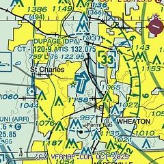
| Sectional chart |
|---|
|
CAUTION: Diagram may not be current
 Download PDF
of official airport diagram from the FAA
| Airport distance calculator |
|---|
|
|
| Sunrise and sunset |
|---|
|
Times for 19-Mar-2026
| | Local
(UTC-5) | | Zulu
(UTC) |
|---|
| Morning civil twilight | | 06:31 | | 11:31 |
| Sunrise | | 06:59 | | 11:59 |
| Sunset | | 19:03 | | 00:03 |
| Evening civil twilight | | 19:30 | | 00:30 |
|
| Current date and time |
|---|
| Zulu (UTC) | 19-Mar-2026 22:58:03 |
|---|
| Local (UTC-5) | 19-Mar-2026 17:58:03 |
|---|
|
| METAR |
|---|
| KDPA | 192252Z 07010KT 9SM CLR 12/03 A3004 RMK AO2 SLP175 T01220028
|
K06C
8nm NE | 192235Z AUTO 06008KT 10SM CLR 11/01 A3006 RMK AO2 T01100009
|
KARR
13nm SW | 192252Z 06011KT 5SM HZ CLR 16/06 A3002 RMK AO2 SLP167 T01610056
|
KORD
15nm E | 192251Z 07007KT 10SM BKN250 10/M01 A3006 RMK AO2 SLP181 T01001006 $
|
KLOT
19nm S | 192245Z 06010G15KT 10SM CLR 14/05 A3004
|
KPWK
20nm NE | 192252Z 09007KT 10SM CLR 08/M01 A3008 RMK AO2 SLP189 T00781006
|
|
| TAF |
|---|
| KDPA | 192050Z 1921/2018 09007KT P6SM FEW250 FM200600 22007KT P6SM SCT150 BKN250 FM201500 29012KT P6SM FEW100 BKN250
|
KORD
15nm E | 192050Z 1921/2024 08008KT P6SM FEW250 FM200600 23008KT P6SM SCT150 BKN250 FM201500 29012KT P6SM FEW100 BKN250 FM201900 02010KT P6SM SCT020 SCT250
|
|
| NOTAMs |
|---|
NOTAMs are issued by the DoD/FAA and will open in a separate window not controlled by AirNav.
|
|


