FAA INFORMATION EFFECTIVE 11 JUNE 2026
Location
| FAA Identifier: | DYR |
| Lat/Long: | 35-59-52.7000N 089-24-23.7000W
35-59.878333N 089-24.395000W
35.9979722,-89.4065833
(estimated) |
| Elevation: | 337.7 ft. / 102.9 m (surveyed) |
| Variation: | 01W (2005) |
| From city: | 2 miles S of DYERSBURG, TN |
| Time zone: | UTC -5 (UTC -6 during Standard Time) |
| Zip code: | 38024 |
Airport Operations
| Airport use: | Open to the public |
| Activation date: | 07/1944 |
| Control tower: | no |
| ARTCC: | MEMPHIS CENTER |
| FSS: | JACKSON FLIGHT SERVICE STATION |
| NOTAMs facility: | DYR (NOTAM-D service available) |
| Attendance: | MON-FRI 0700-1700, ALL SAT-SUN 0800-1700 |
| Wind indicator: | lighted |
| Segmented circle: | yes |
| Lights: | ACTVT REIL RWY 04 & 22; MIRL RWY 04/22 - CTAF. PAPI RWY 04 & 22 ON CONSLY. |
| Beacon: | white-green (lighted land airport)
Operates sunset to sunrise. |
Airport Communications
| CTAF/UNICOM: | 123.05 |
| WX AWOS-3PT: | 135.625 (731-737-9482) |
- APCH/DEP SVC PRVDD BY MEMPHIS ARTCC ON FREQS 134.65/316.15 (MCKELLAR RCAG).
Nearby radio navigation aids
| VOR radial/distance | | VOR name | | Freq | | Var |
|---|
| MKLr315/33.8 | | MC KELLAR VOR/DME | | 114.85 | | 01W |
Airport Services
| Fuel available: | 100LL JET-A+ |
| Parking: | hangars and tiedowns |
| Airframe service: | NONE |
| Powerplant service: | NONE |
| Bottled oxygen: | NONE |
| Bulk oxygen: | NONE |
Runway Information
Runway 4/22
| Dimensions: | 5698 x 98 ft. / 1737 x 30 m |
| Surface: | asphalt, in good condition |
| Weight bearing capacity: | | PCN 9 /F/D/X/T | | Single wheel: | 24.0 |
|
| Runway edge lights: | medium intensity |
| RUNWAY 4 | | RUNWAY 22 |
| Latitude: | 35-59.426350N | | 36-00.140075N |
| Longitude: | 089-24.833603W | | 089-24.082617W |
| Elevation: | 291.5 ft. | | 334.6 ft. |
| Traffic pattern: | left | | left |
| Runway heading: | 041 magnetic, 040 true | | 222 magnetic, 221 true |
| Displaced threshold: | no | | 694 ft. |
| Markings: | nonprecision, in good condition | | nonprecision, in good condition |
| Visual slope indicator: | 4-light PAPI on left (3.00 degrees glide path) | | 4-light PAPI on left (3.00 degrees glide path) |
| Runway end identifier lights: | yes | | yes |
| Touchdown point: | yes, no lights | | yes, no lights |
| Obstructions: | 69 ft. tree, 1471 ft. from runway, 370 ft. left of centerline, 18:1 slope to clear | | none |
Runway 16/34
| Dimensions: | 4001 x 74 ft. / 1220 x 23 m |
| Surface: | asphalt, in poor condition |
| Weight bearing capacity: | | Single wheel: | 50.0 | | Double wheel: | 75.0 | | Double tandem: | 135.0 |
|
| Operational restrictions: | CLSD INDEFLY. |
| RUNWAY 16 | | RUNWAY 34 |
| Latitude: | 36-00.327437N | | 35-59.701988N |
| Longitude: | 089-24.434537W | | 089-24.177650W |
| Elevation: | 337.7 ft. | | 325.3 ft. |
| Traffic pattern: | left | | left |
| Runway heading: | 163 magnetic, 162 true | | 343 magnetic, 342 true |
| Markings: | basic, in fair condition | | basic, in fair condition |
| Touchdown point: | yes, no lights | | yes, no lights |
| Obstructions: | 27 ft. tree, 947 ft. from runway, 292 ft. left of centerline, 27:1 slope to clear | | 78 ft. tree, 816 ft. from runway, 355 ft. left of centerline, 7:1 slope to clear |
Airport Ownership and Management from official FAA records
| Ownership: | Publicly-owned |
| Owner: | CITY OF DYERSBURG
CITY HALL, PO BOX 1358
DYERSBURG, TN 38024
Phone (731) 288-7600 |
| Manager: | DIAN DAWSON
315 AIRPORT ROAD
DYERSBURG, TN 38024
Phone 731-445-3979 |
Additional Remarks
| - | FOR CD CTC MEMPHIS ARTCC AT 901-368-8453/8449. |
Instrument Procedures
NOTE: All procedures below are presented as PDF files. If you need a reader for these files, you should download the free Adobe Reader.NOT FOR NAVIGATION. Please procure official charts for flight.
FAA instrument procedures published for use from 11 June 2026 at 0901Z to 09 July 2026 at 0900z.
IAPs - Instrument Approach Procedures |
|---|
| RNAV (GPS) RWY 04 | |
download (238KB) |
| RNAV (GPS) RWY 22 | |
download (207KB) |
| NOTE: Special Alternate Minimums apply | |
download (137KB) |
| NOTE: Special Take-Off Minimums/Departure Procedures apply | |
download (359KB) |
Other nearby airports with instrument procedures:
M05 - Caruthersville Memorial Airport (17 nm NW)
KHKA - Blytheville Municipal Airport (21 nm W)
M12 - Steele Municipal Airport (23 nm W)
KBYH - Arkansas International Airport (26 nm W)
M04 - Covington Municipal Airport (26 nm S)
|
|

Road maps at:
MapQuest
Bing
Google
| Aerial photo |
|---|
WARNING: Photo may not be current or correct
 Photo by Tommy Gibbons
Photo taken 29-Feb-2012
looking west.
Photo by Tommy Gibbons
Photo taken 29-Feb-2012
looking west.
Do you have a better or more recent aerial photo of Dyersburg Regional Airport that you would like to share? If so, please send us your photo.
|
| Sectional chart |
|---|
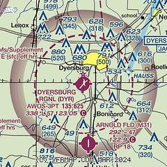
|
| Airport distance calculator |
|---|
|
|
| Sunrise and sunset |
|---|
|
Times for 17-Jun-2026
| | Local
(UTC-5) | | Zulu
(UTC) |
|---|
| Morning civil twilight | | 05:11 | | 10:11 |
| Sunrise | | 05:41 | | 10:41 |
| Sunset | | 20:15 | | 01:15 |
| Evening civil twilight | | 20:46 | | 01:46 |
|
| Current date and time |
|---|
| Zulu (UTC) | 18-Jun-2026 02:52:16 |
|---|
| Local (UTC-5) | 17-Jun-2026 21:52:16 |
|---|
|
| METAR |
|---|
| KDYR | 180156Z AUTO 19005KT 10SM CLR A2967 RMK AO2 SLPNO FZRANO $
|
|
| TAF |
|---|
KMKL
34nm SE | 171735Z 1718/1818 21014G25KT P6SM BKN020 FM171900 20014G22KT P6SM FEW040 FM180600 20008KT P6SM SCT250 FM181100 20007KT P6SM BKN025 PROB30 1814/1818 P6SM -RA BKN020
|
|
| NOTAMs |
|---|
NOTAMs are issued by the DoD/FAA and will open in a separate window not controlled by AirNav.
|
|

