FAA INFORMATION EFFECTIVE 27 NOVEMBER 2025
Location
| FAA Identifier: | EDG |
| Lat/Long: | 39-23-30.7450N 076-17-28.0460W
39-23.512417N 076-17.467433W
39.3918736,-76.2911239
(estimated) |
| Elevation: | 21.3 ft. / 6.5 m (surveyed) |
| Variation: | 10W (1985) |
| From city: | 2 miles S of EDGEWOOD ARSENAL, MD |
| Time zone: | UTC -5 (UTC -4 during Daylight Saving Time) |
| Zip code: | 21010 |
Heliport Operations
| Heliport use: | Private use. Permission required prior to landing |
| Activation date: | 05/1941 |
| Control tower: | no |
| ARTCC: | WASHINGTON CENTER |
| FSS: | LEESBURG FLIGHT SERVICE STATION |
| NOTAMs facility: | DCA (NOTAM-D service available) |
| Attendance: | TUE-FRI 0630-1700 EXCLD HOL. |
| Pattern altitude: | 721.3 ft. MSL
700 FT WEST TRAFFIC PATTERN ONLY FOR ROTARY WING ACFT. |
| Segmented circle: | no |
| Lights: | WHEN FLT OPS CLSD, ACTVT MIRL - CTAF. |
Heliport Communications
| CTAF: | 126.2 |
| POTOMAC APPROACH: | 125.525 |
| POTOMAC DEPARTURE: | 125.525 |
| WX AWOS-3PT at MTN (7 nm SW): | PHONE 410-682-8848 |
| WX AWOS-3PT at 0W3 (11 nm N): | 132.725 (667-340-6003) |
Nearby radio navigation aids
| VOR radial/distance | | VOR name | | Freq | | Var |
|---|
| BALr063/21.7 | | BALTIMORE VORTAC | | 115.10 | | 11W |
| EMIr109/32.4 | | WESTMINSTER VORTAC | | 117.90 | | 08W |
| DQOr252/36.0 | | DUPONT VORTAC | | 114.00 | | 10W |
| ENOr294/37.2 | | SMYRNA VORTAC | | 111.40 | | 09W |
| NDB name | | Hdg/Dist | | Freq | | Var | | ID |
|---|
| ELLICOTT | | 085/23.4 | | 371 | | 11W | | FND | ..-. -. -.. |
Heliport Services
| Fuel available: | FUEL: J8. |
Runway Information
Runway 1/19
| Dimensions: | 1704 x 85 ft. / 519 x 26 m |
| Surface: | asphalt |
| Runway edge lights: | medium intensity |
| Operational restrictions: | HELICOPTER LANDING STRIP. |
| RUNWAY 1 | | RUNWAY 19 |
| Latitude: | 39-23.372550N | | 39-23.652267N |
| Longitude: | 076-17.452683W | | 076-17.482200W |
| Elevation: | 21.3 ft. | | 14.1 ft. |
| Traffic pattern: | left | | left |
| Markings: | basic, in good condition | | basic, in good condition |
| Touchdown point: | yes, no lights | | yes, no lights |
Helipad H1
| Dimensions: | 80 x 80 ft. / 24 x 24 m |
| Surface: | asphalt |
| Latitude: | 39-23.645700N
SOUTH END OF LANDING STRIP COORDS/ELEVATION - 39-23-39.1360N 76-17-28.9320W/ 14.1 FT. | | |
| Longitude: | 076-17.481500W | | |
| Elevation: | 14.1 ft. | | |
| Traffic pattern: | left | | left |
Heliport Ownership and Management from official FAA records
| Ownership: | U.S. Army |
| Owner: | US ARMY WEIDE ARMY HELIPORT
9325 GUNSTON ROAD
FT BELVOIR, VA 22060 |
| Manager: | STATE ARMY AVIATION OFFICER
MARYLAND ARMY NAT'L GUARD, BLDG E 4081
APG, MD 21010-5401
Phone 410-436-3536 |
Additional Remarks
| - | 126.2, CTAF, 3 CLICKS FOR AWOS AND 4 CLICKS FOR COMM CHECK. |
| - | REMARKS- WKD MISC: 4AGPU, FUEL- TUUE-FRI CTC 576-9755/9702, 618-256-9755/9702 C540-349-7526 C866-598-9525, C703-563-3224. |
| - | MULT HELICOPTER SLING LOAD BLOCKS SW SOD. |
| - | H1 PAD LIMITED TO DAY ONLY. |
| - | CTC AR OPS ON 126.2/229.4/241.0. |
| - | VFR ADVISORY ON 126.2/229.4. VFR ADVISORY AVBL 0800-1630 MON-FRI OTHER TIMES ON PRIOR REQUEST. |
| - | 'ROTARY WING AIRCRAFT' TRAFFIC ONLY. NO FIX WING TRAFFIC ALLOWED. |
| - | HELICOPTER NVG OPNS SUNSET TO 2400. |
| - | MISC: WX BRIEFING SVC AVBL 24/7 15 OWS, SCOTT AFB DSN 312-576-9697, COM 618-256-9697 NIPRNET HTTPS://OWS.SCOTT.AF.MI |
| - | HELIPORT LIES W/IN R 4001A APPROACH/DEPART HELIPORT WEST AND NORTH DO NOT FLY BYD 4,500 SOUTH OF RY. |
| - | RSTD: ALL TRAN ACFT 24 HR PPR TUE-FRI ONLY. |
| - | 24/7 PHONE MARYLAND JOINT OPERATIONS CENTER 410-702-9000. |
| - | FOR CD CTC POTOMAC APCH AT 866-429-5882. |
Instrument Procedures
NOTE: All procedures below are presented as PDF files. If you need a reader for these files, you should download the free Adobe Reader.NOT FOR NAVIGATION. Please procure official charts for flight.
FAA instrument procedures published for use from 27 November 2025 at 0901Z to 25 December 2025 at 0900Z.
IAPs - Instrument Approach Procedures |
|---|
| COPTER RNAV (GPS) 185 | |
download (70KB) |
Departure Procedures |
|---|
| JIRET ONE (RNAV) | |
download (71KB) |
| NOTE: Special Take-Off Minimums/Departure Procedures apply | |
download (363KB) |
Other nearby airports with instrument procedures:
KMTN - Martin State Airport (7 nm SW)
KAPG - Phillips Army Airfield (7 nm NE)
0W3 - Harford County Airport (11 nm N)
KBWI - Baltimore/Washington International Thurgood Marshall Airport (22 nm SW)
58M - Claremont Airport (22 nm NE)
|
|

Road maps at:
MapQuest
Bing
Google
| Aerial photo |
|---|

|
| Sectional chart |
|---|
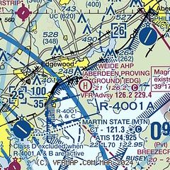
|
| Airport distance calculator |
|---|
|
|
| Sunrise and sunset |
|---|
|
Times for 24-Dec-2025
| | Local
(UTC-5) | | Zulu
(UTC) |
|---|
| Morning civil twilight | | 06:54 | | 11:54 |
| Sunrise | | 07:24 | | 12:24 |
| Sunset | | 16:45 | | 21:45 |
| Evening civil twilight | | 17:16 | | 22:16 |
|
| Current date and time |
|---|
| Zulu (UTC) | 24-Dec-2025 09:27:44 |
|---|
| Local (UTC-5) | 24-Dec-2025 04:27:44 |
|---|
|
| METAR |
|---|
KMTN
7nm SW | 240915Z AUTO 00000KT 5SM BR CLR 01/00 A3003 RMK AO2 T00060000
|
KAPG
11nm NE | 231957Z 22003KT 10SM OVC030 04/02 A3005 RMK SLP179
|
KDMH
16nm SW | 240853Z AUTO 05/02 A3000 RMK AO1 SLP160 T00500022 53004
|
|
| TAF |
|---|
KMTN
7nm SW | 240538Z 2406/2506 00000KT P6SM BKN050 WS020/31030KT FM240800 27005KT P6SM SCT050 WS020/31040KT FM241100 29008KT P6SM FEW050 FM241400 32015G25KT P6SM FEW250 FM242000 33009KT P6SM FEW250 FM250100 00000KT P6SM FEW150 BKN250
|
|
| NOTAMs |
|---|
NOTAMs are issued by the DoD/FAA and will open in a separate window not controlled by AirNav.
|
|

