FAA INFORMATION EFFECTIVE 25 DECEMBER 2025
Location
| FAA Identifier: | EST |
| Lat/Long: | 43-24-26.9000N 094-44-47.0000W
43-24.448333N 094-44.783333W
43.4074722,-94.7463889
(estimated) |
| Elevation: | 1318.8 ft. / 402.0 m (surveyed) |
| Variation: | 01E (2020) |
| From city: | 4 miles E of ESTHERVILLE, IA |
| Time zone: | UTC -6 (UTC -5 during Daylight Saving Time) |
| Zip code: | 51334 |
Airport Operations
| Airport use: | Open to the public |
| Activation date: | 08/1942 |
| Control tower: | no |
| ARTCC: | MINNEAPOLIS CENTER |
| FSS: | FORT DODGE FLIGHT SERVICE STATION |
| NOTAMs facility: | EST (NOTAM-D service available) |
| Attendance: | DAWN-DUSK
FOR SERVICE AFTER HRS CALL 712-362-2761. |
| Wind indicator: | lighted |
| Segmented circle: | no |
| Lights: | ACTVT MIRL RY 16/34; REIL RYS 16 & 34; PAPI RYS 16 & 34 - CTAF. |
| Beacon: | white-green (lighted land airport)
Operates sunset to sunrise. |
Airport Communications
| CTAF/UNICOM: | 122.975 |
| WX ASOS: | 121.425 (712-362-7250) |
| WX AWOS-3 at MJQ (18 nm NW): | 118.1 (507-847-5810) |
- APCH/DEP SVC PRVDD BY MINNEAPOLIS ARTCC ON FREQS 127.75/257.7 (FAIRMONT RCAG).
Nearby radio navigation aids
| VOR radial/distance | | VOR name | | Freq | | Var |
|---|
| SPWr048/24.7 | | SPENCER VOR/DME | | 115.15 | | 05E |
Airport Services
| Fuel available: | 100LL JET-A+ |
| Airframe service: | MAJOR |
| Powerplant service: | MAJOR |
| Bottled oxygen: | NONE |
| Bulk oxygen: | NONE |
Runway Information
Runway 16/34
| Dimensions: | 4797 x 75 ft. / 1462 x 23 m |
| Surface: | concrete, in good condition |
| Weight bearing capacity: | |
| Runway edge lights: | medium intensity |
| RUNWAY 16 | | RUNWAY 34 |
| Latitude: | 43-24.883627N | | 43-24.107105N |
| Longitude: | 094-44.895040W | | 094-44.699397W |
| Elevation: | 1316.7 ft. | | 1317.5 ft. |
| Traffic pattern: | left | | left |
| Runway heading: | 169 magnetic, 170 true | | 349 magnetic, 350 true |
| Markings: | nonprecision, in good condition | | nonprecision, in good condition |
| Visual slope indicator: | 4-light PAPI on left (3.00 degrees glide path) | | 4-light PAPI on left (3.00 degrees glide path) |
| Runway end identifier lights: | yes
REIL ARE OMNIDIRECTIONAL. | | yes |
| Touchdown point: | yes, no lights | | yes, no lights |
| Obstructions: | none | | 19 ft. road, 850 ft. from runway, 34:1 slope to clear |
Runway 6/24
| Dimensions: | 2989 x 90 ft. / 911 x 27 m |
| Surface: | turf, in fair condition |
| Runway edge markings: | 06/24 MARKED WITH YELLOW CONES. |
| RUNWAY 6 | | RUNWAY 24 |
| Latitude: | 43-24.298380N | | 43-24.444567N |
| Longitude: | 094-45.081338W | | 094-44.436962W |
| Elevation: | 1312.9 ft. | | 1312.5 ft. |
| Traffic pattern: | left | | left |
| Runway heading: | 072 magnetic, 073 true | | 252 magnetic, 253 true |
| Markings: | none, in fair condition | | none, in fair condition |
| Touchdown point: | yes, no lights | | yes, no lights |
| Obstructions: | none | | 15 ft. road, 575 ft. from runway, 38:1 slope to clear |
Airport Ownership and Management from official FAA records
| Ownership: | Publicly-owned |
| Owner: | CITY OF ESTHERVILLE
2 N 7TH ST
ESTHERVILLE, IA 51334
Phone 712-362-7771 |
| Manager: | PAUL SLAUGHTER
1672 425TH AVENUE
ESTHERVILLE, IA 51334
Phone 712-362-2761
ESTHERVILLE AVIATION |
Additional Remarks
| - | RY 34 IS CALM WIND RY. |
| - | FOR CD CTC MINNEAPOLIS ARTCC AT 651-463-5588. |
Instrument Procedures
NOTE: All procedures below are presented as PDF files. If you need a reader for these files, you should download the free Adobe Reader.NOT FOR NAVIGATION. Please procure official charts for flight.
FAA instrument procedures published for use from 25 December 2025 at 0901z to 22 January 2026 at 0900z.
IAPs - Instrument Approach Procedures |
|---|
| RNAV (GPS) RWY 16 | |
download (232KB) |
| RNAV (GPS) RWY 34 | |
download (235KB) |
| NOTE: Special Alternate Minimums apply | |
download (20KB) |
Other nearby airports with instrument procedures:
KMJQ - Jackson Municipal Airport (18 nm NW)
KEGQ - Emmetsburg Municipal Airport (18 nm S)
4D8 - Fuller Airport (19 nm W)
KFRM - Fairmont Municipal Airport (20 nm NE)
KSPW - Spencer Municipal Airport (25 nm SW)
|
|

Road maps at:
MapQuest
Bing
Google
| Aerial photo |
|---|
WARNING: Photo may not be current or correct
 Taken in September 2016
looking northwest.
Taken in September 2016
looking northwest.
Do you have a better or more recent aerial photo of Estherville Municipal Airport that you would like to share? If so, please send us your photo.
|
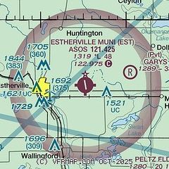
| Sectional chart |
|---|
|
| Airport distance calculator |
|---|
|
|
| Sunrise and sunset |
|---|
|
Times for 19-Jan-2026
| | Local
(UTC-6) | | Zulu
(UTC) |
|---|
| Morning civil twilight | | 07:16 | | 13:16 |
| Sunrise | | 07:47 | | 13:47 |
| Sunset | | 17:12 | | 23:12 |
| Evening civil twilight | | 17:44 | | 23:44 |
|
| Current date and time |
|---|
| Zulu (UTC) | 19-Jan-2026 10:54:47 |
|---|
| Local (UTC-6) | 19-Jan-2026 04:54:47 |
|---|
|
| METAR |
|---|
| KEST | 191036Z AUTO 32024G33KT 10SM BKN014 M20/M24 A3028 RMK AO2 PK WND 32033/1035 T12001244
|
KMJQ
17nm NW | 191035Z AUTO 31017G25KT 10SM M21/M24 A3027 RMK AO2
|
KFRM
20nm NE | 190956Z AUTO 32018G31KT 7SM BKN016 M21/M24 A3028 RMK AO2 PK WND 33032/0926 SNB16E28 SLP287 P0000 T12061239 FZRANO
|
|
| NOTAMs |
|---|
NOTAMs are issued by the DoD/FAA and will open in a separate window not controlled by AirNav.
|
|

