FAA INFORMATION EFFECTIVE 22 JANUARY 2026
Location
| FAA Identifier: | EGQ |
| Lat/Long: | 43-06-07.4000N 094-42-16.3000W
43-06.123333N 094-42.271667W
43.1020556,-94.7045278
(estimated) |
| Elevation: | 1206.1 ft. / 367.6 m (surveyed) |
| Variation: | 04E (2000) |
| From city: | 1 mile SW of EMMETSBURG, IA |
| Time zone: | UTC -6 (UTC -5 during Daylight Saving Time) |
| Zip code: | 50536 |
Airport Operations
| Airport use: | Open to the public |
| Activation date: | 03/1945 |
| Control tower: | no |
| ARTCC: | MINNEAPOLIS CENTER |
| FSS: | FORT DODGE FLIGHT SERVICE STATION |
| NOTAMs facility: | FOD (NOTAM-D service available) |
| Attendance: | IRREGULAR |
| Wind indicator: | lighted |
| Segmented circle: | no |
| Lights: | ACTVT MIRL RY 13/31, REIL & PAPI RYS 13 & 31 - CTAF. |
| Beacon: | white-green (lighted land airport)
Operates sunset to sunrise. |
Airport Communications
| CTAF/UNICOM: | 122.8 |
| WX ASOS at EST (18 nm N): | 121.425 (712-362-7250) |
| WX AWOS-3 at AXA (19 nm E): | 118.475 (515-295-9634) |
- APCH/DEP SVC PRVDD BY MINNEAPOLIS ARTCC ON FREQS 127.75/257.7 (FAIRMONT RCAG).
Nearby radio navigation aids
| VOR radial/distance | | VOR name | | Freq | | Var |
|---|
| SPWr094/22.0 | | SPENCER VOR/DME | | 115.15 | | 05E |
Airport Services
| Fuel available: | 100LL |
| Parking: | hangars and tiedowns |
| Airframe service: | NONE |
| Powerplant service: | NONE |
| Bottled oxygen: | NONE |
| Bulk oxygen: | NONE |
Runway Information
Runway 13/31
| Dimensions: | 3401 x 60 ft. / 1037 x 18 m |
| Surface: | concrete, in good condition |
| Weight bearing capacity: | | PCN 5 /R/C/W/U | | Single wheel: | 29.0 |
|
| Runway edge lights: | medium intensity |
| RUNWAY 13 | | RUNWAY 31 |
| Latitude: | 43-06.427827N | | 43-06.021400N |
| Longitude: | 094-42.701945W | | 094-42.176483W |
| Elevation: | 1205.6 ft. | | 1205.1 ft. |
| Traffic pattern: | left | | left |
| Runway heading: | 133 magnetic, 137 true | | 313 magnetic, 317 true |
| Markings: | nonprecision, in good condition | | nonprecision, in good condition |
| Visual slope indicator: | 4-light PAPI on left (4.00 degrees glide path) | | 4-light PAPI on left (3.00 degrees glide path) |
| Runway end identifier lights: | yes | | yes |
| Touchdown point: | yes, no lights | | yes, no lights |
| Obstructions: | 55 ft. trees, 434 ft. from runway, 224 ft. right of centerline, 4:1 slope to clear | | 62 ft. tree, 1371 ft. from runway, 328 ft. left of centerline, 18:1 slope to clear |
Runway 4/22
| Dimensions: | 2537 x 120 ft. / 773 x 37 m |
| Surface: | turf, in fair condition |
| Runway edge markings: | 04/22 THRS & SIDES MARKED WITH YELLOW CONES. |
| RUNWAY 4 | | RUNWAY 22 |
| Latitude: | 43-05.884752N | | 43-06.181132N |
| Longitude: | 094-42.396565W | | 094-41.994978W |
| Elevation: | 1201.6 ft. | | 1204.9 ft. |
| Traffic pattern: | left | | left |
| Runway heading: | 041 magnetic, 045 true | | 221 magnetic, 225 true |
| Touchdown point: | yes, no lights | | yes, no lights |
| Obstructions: | 11 ft. road, 230 ft. from runway, 20:1 slope to clear
UNLIT CRANE | | 70 ft. other, 893 ft. from runway, 350 ft. left of centerline, 12:1 slope to clear |
Runway 17/35
| Dimensions: | 2157 x 150 ft. / 657 x 46 m |
| Surface: | turf, in fair condition |
| Runway edge markings: | 17/35 THLDS & SIDES MARKED WITH YELLOW CONES. |
| RUNWAY 17 | | RUNWAY 35 |
| Latitude: | 43-06.248090N | | 43-05.893000N |
| Longitude: | 094-42.094718W | | 094-42.098217W |
| Elevation: | 1203.5 ft. | | 1201.5 ft. |
| Traffic pattern: | left | | left |
| Runway heading: | 176 magnetic, 180 true | | 356 magnetic, 000 true |
| Touchdown point: | yes, no lights | | yes, no lights |
| Obstructions: | 36 ft. tree, 565 ft. from runway, 108 ft. right of centerline, 15:1 slope to clear | | 45 ft. tree, 341 ft. from runway, 14 ft. left of centerline, 7:1 slope to clear |
Airport Ownership and Management from official FAA records
| Ownership: | Publicly-owned |
| Owner: | CITY OF EMMETSBURG
2021 MAIN
EMMETSBURG, IA 50536
Phone 712-852-4030 |
| Manager: | KIMBERLY KIBBIE
3775 450TH STREET
EMMETSBURG, IA 50536
Phone 712-852-4030 |
Additional Remarks
| - | FOR CD CTC MINNEAPOLIS ARTCC AT 651-463-5588. |
Instrument Procedures
NOTE: All procedures below are presented as PDF files. If you need a reader for these files, you should download the free Adobe Reader.NOT FOR NAVIGATION. Please procure official charts for flight.
FAA instrument procedures published for use from 22 January 2026 at 0901Z to 19 February 2026 at 0900z.
IAPs - Instrument Approach Procedures |
|---|
| RNAV (GPS) RWY 13 | |
download (217KB) |
| RNAV (GPS) RWY 31 | |
download (215KB) |
| NOTE: Special Take-Off Minimums/Departure Procedures apply | |
download (440KB) |
Other nearby airports with instrument procedures:
KEST - Estherville Municipal Airport (18 nm N)
KAXA - Algona Municipal Airport (19 nm E)
KPOH - Pocahontas Municipal Airport (22 nm S)
KSPW - Spencer Municipal Airport (22 nm W)
4D8 - Fuller Airport (24 nm NW)
|
|

Road maps at:
MapQuest
Bing
Google
| Aerial photo |
|---|
WARNING: Photo may not be current or correct
 Photo taken 23-Jun-2010
Do you have a better or more recent aerial photo of Emmetsburg Municipal Airport that you would like to share? If so, please send us your photo.
|
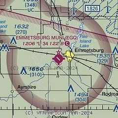
| Sectional chart |
|---|
|
| Airport distance calculator |
|---|
|
|
| Sunrise and sunset |
|---|
|
Times for 10-Feb-2026
| | Local
(UTC-6) | | Zulu
(UTC) |
|---|
| Morning civil twilight | | 06:55 | | 12:55 |
| Sunrise | | 07:24 | | 13:24 |
| Sunset | | 17:42 | | 23:42 |
| Evening civil twilight | | 18:11 | | 00:11 |
|
| Current date and time |
|---|
| Zulu (UTC) | 10-Feb-2026 20:48:23 |
|---|
| Local (UTC-6) | 10-Feb-2026 14:48:23 |
|---|
|
| METAR |
|---|
KEST
18nm N | 101952Z AUTO 32016KT 10SM CLR 03/M04 A3012 RMK AO2 SLP211 T00331039
|
KAXA
19nm E | 102035Z AUTO 33016G21KT 10SM CLR 04/M01 A3009 RMK A01
|
KSPW
23nm W | 101953Z AUTO 35015G22KT 10SM CLR 06/M04 A3012 RMK AO2 PK WND 33026/1914 SLP211 T00561039
|
KMJQ
34nm N | 102035Z AUTO 32016G21KT 10SM CLR 03/M03 A3011 RMK AO2
|
KFRM
34nm N | 102007Z AUTO 33019G23KT 10SM SCT019 03/M02 A3011 RMK AO2
|
|
| TAF |
|---|
KFOD
42nm SE | 101740Z 1018/1118 34012G20KT P6SM BKN022 FM102200 33012KT P6SM SCT025 FM110000 32006KT P6SM SCT030 FM111000 VRB04KT P6SM SCT020
|
|
| NOTAMs |
|---|
NOTAMs are issued by the DoD/FAA and will open in a separate window not controlled by AirNav.
|
|

