FAA INFORMATION EFFECTIVE 16 APRIL 2026
Location
| FAA Identifier: | POH |
| Lat/Long: | 42-44-34.4000N 094-38-50.5000W
42-44.573333N 094-38.841667W
42.7428889,-94.6473611
(estimated) |
| Elevation: | 1225.5 ft. / 373.5 m (surveyed) |
| Variation: | 02E (2010) |
| From city: | 1 mile NE of POCAHONTAS, IA |
| Time zone: | UTC -5 (UTC -6 during Standard Time) |
| Zip code: | 50574 |
Airport Operations
| Airport use: | Open to the public |
| Activation date: | 04/1940 |
| Control tower: | no |
| ARTCC: | MINNEAPOLIS CENTER |
| FSS: | FORT DODGE FLIGHT SERVICE STATION |
| NOTAMs facility: | FOD (NOTAM-D service available) |
| Attendance: | UNATNDD
FOR SVC CALL SHERIFFS OFFICE (712) 335-3308. |
| Wind indicator: | lighted |
| Segmented circle: | yes |
| Lights: | ACTVT REIL RWY 12 & 30; PAPI RWY 12 & 30; MIRL RWY 12/30 - CTAF. |
| Beacon: | white-green (lighted land airport)
Operates sunset to sunrise. |
Airport Communications
- APCH/DEP SVC PRVDD BY MINNEAPOLIS ARTCC ON FREQS 134.0/288.3 (FORT DODGE RCAG).
Nearby radio navigation aids
| VOR radial/distance | | VOR name | | Freq | | Var |
|---|
| SPWr131/35.0 | | SPENCER VOR/DME | | 115.15 | | 05E |
Airport Services
| Fuel available: | 100LL |
| Parking: | hangars and tiedowns |
Runway Information
Runway 12/30
| Dimensions: | 4100 x 60 ft. / 1250 x 18 m |
| Surface: | asphalt, in good condition |
| Weight bearing capacity: | | PCN 12 /R/B/W/U | | Single wheel: | 15.0 |
|
| Runway edge lights: | medium intensity |
| Operational restrictions: | RWY 30 CALM WIND RWY. |
| RUNWAY 12 | | RUNWAY 30 |
| Latitude: | 42-44.742647N | | 42-44.390550N |
| Longitude: | 094-39.273460W | | 094-38.492360W |
| Elevation: | 1225.5 ft. | | 1221.0 ft. |
| Traffic pattern: | left | | left |
| Runway heading: | 119 magnetic, 121 true | | 299 magnetic, 301 true |
| Markings: | nonprecision, in fair condition | | nonprecision, in fair condition |
| Visual slope indicator: | 2-light PAPI on left (3.00 degrees glide path) | | 2-light PAPI on left (3.00 degrees glide path) |
| Runway end identifier lights: | yes | | yes |
| Touchdown point: | yes, no lights | | yes, no lights |
| Obstructions: | 62 ft. tree, 915 ft. from runway, 355 ft. left of centerline, 11:1 slope to clear | | 15 ft. road, 545 ft. from runway, 260 ft. right of centerline, 23:1 slope to clear |
Runway 18/36
| Dimensions: | 1999 x 135 ft. / 609 x 41 m |
| Surface: | turf, in fair condition |
| Runway edge markings: | YELLOW CONES. |
| Operational restrictions: | NO SNOW REMOVAL, RWY CLSD WHEN SNOW CONDITIONS EXIST. |
| RUNWAY 18 | | RUNWAY 36 |
| Latitude: | 42-44.752270N | | 42-44.424180N |
| Longitude: | 094-38.742010W | | 094-38.775770W |
| Elevation: | 1224.1 ft. | | 1218.3 ft. |
| Traffic pattern: | left | | left |
| Runway heading: | 182 magnetic, 184 true | | 002 magnetic, 004 true |
| Markings: | NSTD, in fair condition | | NSTD, in fair condition |
| Touchdown point: | yes, no lights | | yes, no lights |
| Obstructions: | 19 ft. road, 405 ft. from runway, 21:1 slope to clear | | none |
Airport Ownership and Management from official FAA records
| Ownership: | Publicly-owned |
| Owner: | CITY OF POCAHONTAS
CITY HALL 23 WEST ELM
POCAHONTAS, IA 50574
Phone 712-335-4841 |
| Manager: | DENNIS DAHL
212 SOUTH MAIN
POCAHONTAS, IA 50574
Phone 712-335-4236
OFFICE NUMBER 712-335-4382 |
Additional Remarks
| - | FOR CD CTC MINNEAPOLIS ARTCC AT 651-463-5588. |
Instrument Procedures
NOTE: All procedures below are presented as PDF files. If you need a reader for these files, you should download the free Adobe Reader.NOT FOR NAVIGATION. Please procure official charts for flight.
FAA instrument procedures published for use from 16 April 2026 at 0901Z to 14 May 2026 at 0900Z.
IAPs - Instrument Approach Procedures |
|---|
| RNAV (GPS) RWY 12 | |
download (210KB) |
| RNAV (GPS) RWY 30 | |
download (230KB) |
| NOTE: Special Take-Off Minimums/Departure Procedures apply | |
download (158KB) |
Other nearby airports with instrument procedures:
KEGQ - Emmetsburg Municipal Airport (22 nm N)
KFOD - Fort Dodge Regional Airport (23 nm SE)
KAXA - Algona Municipal Airport (26 nm NE)
KSKI - Sac City Municipal Airport (26 nm SW)
KSLB - Storm Lake Municipal Airport (28 nm W)
|
|

Road maps at:
MapQuest
Bing
Google
| Aerial photo |
|---|
WARNING: Photo may not be current or correct
 Photo by Iden Mersereau
Photo taken 08-Jul-2018
looking north.
Photo by Iden Mersereau
Photo taken 08-Jul-2018
looking north.
Do you have a better or more recent aerial photo of Pocahontas Municipal Airport that you would like to share? If so, please send us your photo.
|
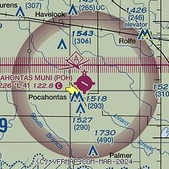
| Sectional chart |
|---|
|
| Airport distance calculator |
|---|
|
|
| Sunrise and sunset |
|---|
|
Times for 25-Apr-2026
| | Local
(UTC-5) | | Zulu
(UTC) |
|---|
| Morning civil twilight | | 05:52 | | 10:52 |
| Sunrise | | 06:22 | | 11:22 |
| Sunset | | 20:11 | | 01:11 |
| Evening civil twilight | | 20:41 | | 01:41 |
|
| Current date and time |
|---|
| Zulu (UTC) | 25-Apr-2026 11:37:20 |
|---|
| Local (UTC-5) | 25-Apr-2026 06:37:20 |
|---|
|
| METAR |
|---|
KFOD
25nm SE | 251056Z AUTO 02009KT 10SM CLR 07/02 A2994 RMK AO2 SLP154 T00720017 $
|
KAXA
26nm NE | 251115Z AUTO 04007KT 10SM CLR 04/04 A2995 RMK A01
|
KSLB
27nm W | 251115Z AUTO 05012KT 10SM CLR 07/00 A2993 RMK AO2
|
KSPW
36nm NW | 251053Z AUTO 04008KT 10SM CLR 05/M04 A2996 RMK AO2 SLP148 T00501039
|
KCAV
39nm E | 251115Z AUTO 04007KT 10SM CLR 06/06 A2996 RMK A01
|
KEBS
40nm SE | 251115Z AUTO 04004KT 10SM CLR 05/04 A2992 RMK AO2
|
KEST
40nm N | 251052Z AUTO 04006KT 10SM CLR 04/M04 A2996 RMK AO2 SLP150 T00441039
|
KCKP
40nm W | 251115Z AUTO 04004KT 10SM CLR 06/M01 A2993 RMK AO2
|
KCIN
43nm S | 251115Z AUTO 02003KT 9SM CLR 05/04 A2993 RMK AO2
|
|
| TAF |
|---|
KFOD
25nm SE | 250520Z 2506/2606 06004KT P6SM SKC FM251500 10007KT P6SM SCT250
|
|
| NOTAMs |
|---|
NOTAMs are issued by the DoD/FAA and will open in a separate window not controlled by AirNav.
|
|

