FAA INFORMATION EFFECTIVE 27 NOVEMBER 2025
Location
| FAA Identifier: | 4D8 |
| Lat/Long: | 43-20-00.2180N 095-09-32.7330W
43-20.003633N 095-09.545550W
43.3333939,-95.1590925
(estimated) |
| Elevation: | 1439 ft. / 438.6 m (surveyed) |
| Variation: | 05E (1980) |
| From city: | 1 mile NW of MILFORD, IA |
| Time zone: | UTC -6 (UTC -5 during Daylight Saving Time) |
| Zip code: | 51351 |
Airport Operations
| Airport use: | Open to the public |
| Activation date: | 07/1945 |
| Control tower: | no |
| ARTCC: | MINNEAPOLIS CENTER |
| FSS: | FORT DODGE FLIGHT SERVICE STATION |
| NOTAMs facility: | FOD (NOTAM-D service available) |
| Attendance: | UNATNDD |
| Wind indicator: | lighted |
| Segmented circle: | yes |
| Lights: | SS-SR |
Airport Communications
| CTAF: | 122.9 |
| WX ASOS at SPW (10 nm S): | 126.625 (712-262-8885) |
| WX ASOS at EST (19 nm E): | 121.425 (712-362-7250) |
- APCH/DEP SVC PRVDD BY MINNEAPOLIS ARTCC ON FREQS 127.75/257.7 (FAIRMONT RCAG).
Nearby radio navigation aids
| VOR radial/distance | | VOR name | | Freq | | Var |
|---|
| SPWr005/10.4 | | SPENCER VOR/DME | | 115.15 | | 05E |
| NDB name | | Hdg/Dist | | Freq | | Var | | ID |
|---|
| SNORE | | 046/9.5 | | 394 | | 05E | | SP | ... .--. |
Airport Services
| Fuel available: | 100LL
100LL:SELF SERVE 100LL. |
| Parking: | tiedowns |
| Airframe service: | NONE |
| Powerplant service: | NONE |
| Bottled oxygen: | NONE |
| Bulk oxygen: | NONE |
Runway Information
Runway 9/27
| Dimensions: | 2873 x 50 ft. / 876 x 15 m |
| Surface: | asphalt, in good condition |
| Runway edge lights: | low intensity |
| RUNWAY 9 | | RUNWAY 27 |
| Latitude: | 43-20.085167N | | 43-20.086333N |
| Longitude: | 095-09.801000W | | 095-09.153167W |
| Elevation: | 1437.0 ft. | | 1436.0 ft. |
| Traffic pattern: | left | | right |
| Runway heading: | 085 magnetic, 090 true | | 265 magnetic, 270 true |
| Displaced threshold: | 60 ft.
RWY 9 APCH SLP 5:1 TO DTHR. | | 360 ft. |
| Markings: | basic, in fair condition | | basic, in fair condition |
| Touchdown point: | yes, no lights | | yes, no lights |
| Obstructions: | 41 ft. trees, 200 ft. from runway, 143 ft. right of centerline
41 FT TREES 190 FT FM RWY END 143 FT R ON APCH 0:1 CLEARANCE. | | 59 ft. tree, 550 ft. from runway, 173 ft. right of centerline, 9:1 slope to clear
RY 27 APCH SLOPE 24:1 TO DSPLCD THLD. |
Runway 18/36
| Dimensions: | 2200 x 100 ft. / 671 x 30 m |
| Surface: | turf, in fair condition |
| Runway edge lights: | low intensity |
| Runway edge markings: | 18/36 MARKED WITH YELLOW CONES. |
| RUNWAY 18 | | RUNWAY 36 |
| Latitude: | 43-20.077333N | | 43-19.715333N |
| Longitude: | 095-09.635000W | | 095-09.635000W |
| Elevation: | 1436.0 ft. | | 1429.0 ft. |
| Traffic pattern: | right | | left |
| Runway heading: | 175 magnetic, 180 true | | 355 magnetic, 000 true |
| Displaced threshold: | no | | 700 ft. |
| Touchdown point: | yes, no lights | | yes, no lights |
| Obstructions: | 26 ft. tree, 208 ft. from runway, 145 ft. left of centerline, 8:1 slope to clear | | 50 ft. tree, 633 ft. from runway, 87 ft. right of centerline, 12:1 slope to clear
RY 36 APCH SLOPE 20:1 TO DSPLCD THLD. |
Airport Ownership and Management from official FAA records
| Ownership: | Publicly-owned |
| Owner: | CITY OF MILFORD
PO BOX 536
MILFORD, IA 51351
Phone 712-260-4335 |
| Manager: | CHRISTOPHER STEIN
P.O. BOX 463
MILFORD, IA 51351
Phone 712-260-4335 |
Additional Remarks
| - | RY 27 IS CALM WIND RY. |
| - | FOR CD CTC MINNEAPOLIS ARTCC AT 651-463-5588. |
| - | NO SNOW REMOVAL RWY 18/36. RWY CLSD WHEN SNOW CONDS EXIST. |
Instrument Procedures
NOTE: All procedures below are presented as PDF files. If you need a reader for these files, you should download the free Adobe Reader.NOT FOR NAVIGATION. Please procure official charts for flight.
FAA instrument procedures published for use from 27 November 2025 at 0901Z to 25 December 2025 at 0900Z.
IAPs - Instrument Approach Procedures |
|---|
| RNAV (GPS)-B | |
download (160KB) |
| VOR-A | |
download (179KB) |
| NOTE: Special Take-Off Minimums/Departure Procedures apply | |
download (158KB) |
Other nearby airports with instrument procedures:
KSPW - Spencer Municipal Airport (10 nm S)
KEST - Estherville Municipal Airport (19 nm E)
KMJQ - Jackson Municipal Airport (20 nm N)
KEGQ - Emmetsburg Municipal Airport (24 nm SE)
KISB - Sibley Municipal Airport (26 nm W)
|
|

Road maps at:
MapQuest
Bing
Google
| Aerial photo |
|---|
WARNING: Photo may not be current or correct
 Photo taken 23-Apr-2005
Do you have a better or more recent aerial photo of Fuller Airport that you would like to share? If so, please send us your photo.
|
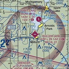
| Sectional chart |
|---|
|
| Airport distance calculator |
|---|
|
|
| Sunrise and sunset |
|---|
|
Times for 21-Dec-2025
| | Local
(UTC-6) | | Zulu
(UTC) |
|---|
| Morning civil twilight | | 07:18 | | 13:18 |
| Sunrise | | 07:51 | | 13:51 |
| Sunset | | 16:47 | | 22:47 |
| Evening civil twilight | | 17:19 | | 23:19 |
|
| Current date and time |
|---|
| Zulu (UTC) | 22-Dec-2025 04:31:54 |
|---|
| Local (UTC-6) | 21-Dec-2025 22:31:54 |
|---|
|
| METAR |
|---|
KSPW
10nm S | 220353Z AUTO 18009KT 10SM BKN120 02/M04 A3014 RMK AO2 PK WND 20027/0308 SLP224 T00221039 $
|
KEST
18nm E | 220352Z AUTO 20013KT 10SM BKN110 02/M04 A3013 RMK AO2 SLP218 T00171039
|
KMJQ
20nm NE | 220415Z AUTO 18008KT 10SM BKN110 01/M04 A3011 RMK AO2
|
|
| NOTAMs |
|---|
NOTAMs are issued by the DoD/FAA and will open in a separate window not controlled by AirNav.
|
|

