FAA INFORMATION EFFECTIVE 09 JULY 2026
Location
| FAA Identifier: | ISB |
| Lat/Long: | 43-22-09.6700N 095-45-34.7000W
43-22.161167N 095-45.578333W
43.3693528,-95.7596389
(estimated) |
| Elevation: | 1537.7 ft. / 469 m (estimated) |
| Variation: | 02E (2020) |
| From city: | 2 miles S of SIBLEY, IA |
| Time zone: | UTC -5 (UTC -6 during Standard Time) |
| Zip code: | 51249 |
Airport Operations
| Airport use: | Open to the public |
| Activation date: | 05/1947 |
| Control tower: | no |
| ARTCC: | MINNEAPOLIS CENTER |
| FSS: | FORT DODGE FLIGHT SERVICE STATION |
| NOTAMs facility: | FOD (NOTAM-D service available) |
| Attendance: | MON - FRI 0600-1800
FOR ATTENDANT AFTER HOURS CALL 712-754-3467. |
| Wind indicator: | lighted |
| Segmented circle: | no |
| Lights: | ACTVT LIRL RY 17/35 AND PAPI RYS 17 & 35 - CTAF. |
Airport Communications
| CTAF/UNICOM: | 122.8 |
| WX AWOS-3 at SHL (10 nm S): | 119.775 (712-324-5159) |
| WX AWOS-3PT at OTG (19 nm NE): | 121.075 (507-804-2951) |
- APCH/DEP SVC PRVDD BY MINNEAPOLIS ARTCC ON FREQS 132.050/317.4 (SIOUX FALLS RCAG).
Nearby radio navigation aids
| VOR radial/distance | | VOR name | | Freq | | Var |
|---|
| SPWr292/27.4 | | SPENCER VOR/DME | | 115.15 | | 05E |
Airport Services
| Fuel available: | 100LL |
| Parking: | hangars and tiedowns |
| Airframe service: | MINOR |
| Powerplant service: | MINOR |
| Bottled oxygen: | NONE |
| Bulk oxygen: | NONE |
Runway Information
Runway 17/35
| Dimensions: | 3000 x 50 ft. / 914 x 15 m |
| Surface: | concrete, in fair condition |
| Weight bearing capacity: | | Single wheel: | 28.0 | | Double wheel: | 48.0 |
|
| Runway edge lights: | non-standard
LIRL-RWY 17/35 HAVE 6 THLD LGTS EACH. |
| RUNWAY 17 | | RUNWAY 35 |
| Latitude: | 43-22.408167N | | 43-21.914167N |
| Longitude: | 095-45.578167W | | 095-45.578500W |
| Elevation: | 1535.8 ft. | | 1522.8 ft. |
| Traffic pattern: | left | | left |
| Runway heading: | 178 magnetic, 180 true | | 358 magnetic, 000 true |
| Markings: | nonprecision, in fair condition | | nonprecision, in fair condition |
| Visual slope indicator: | 2-light PAPI on left (3.00 degrees glide path) | | 2-light PAPI on left (3.00 degrees glide path) |
| Touchdown point: | yes, no lights | | yes, no lights |
| Obstructions: | 15 ft. road, 515 ft. from runway, 206 ft. right of centerline, 21:1 slope to clear | | 77 ft. trees, 1787 ft. from runway, 51 ft. right of centerline, 20:1 slope to clear |
Airport Ownership and Management from official FAA records
| Ownership: | Publicly-owned |
| Owner: | CITY OF SIBLEY
CITY HALL, 808 3RD AVE
SIBLEY, IA 51249
Phone 712-754-2541 |
| Manager: | ROBERT O'LEARY
1928 OLIVE AVENUE
SIBLEY, IA 51249
Phone 712-754-3467 |
Additional Remarks
| - | RY 35 IS CALM WIND RY. |
| - | FOR CD CTC MINNEAPOLIS ARTCC AT 651-463-5588. |
Instrument Procedures
NOTE: All procedures below are presented as PDF files. If you need a reader for these files, you should download the free Adobe Reader.NOT FOR NAVIGATION. Please procure official charts for flight.
FAA instrument procedures published for use from 09 July 2026 at 0901Z to 06 August 2026 at 0900Z.
IAPs - Instrument Approach Procedures |
|---|
| RNAV (GPS)-A **CHANGED** | |
download (159KB) |
| NOTE: Special Take-Off Minimums/Departure Procedures apply | |
download (158KB) |
Other nearby airports with instrument procedures:
KSHL - Sheldon Regional Airport (10 nm S)
KOTG - Worthington Municipal Airport (19 nm NE)
KRRQ - Rock Rapids Municipal Airport (19 nm W)
KLYV - Quentin Aanenson Field Airport (25 nm NW)
4D8 - Fuller Airport (26 nm E)
|
|

Road maps at:
MapQuest
Bing
Google
| Aerial photo |
|---|
WARNING: Photo may not be current or correct
 Photo by Mark Wismer
Photo taken 19-Jul-2010
Photo by Mark Wismer
Photo taken 19-Jul-2010
Do you have a better or more recent aerial photo of Sibley Municipal Airport that you would like to share? If so, please send us your photo.
|
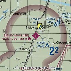
| Sectional chart |
|---|
|
| Airport distance calculator |
|---|
|
|
| Sunrise and sunset |
|---|
|
Times for 15-Jul-2026
| | Local
(UTC-5) | | Zulu
(UTC) |
|---|
| Morning civil twilight | | 05:23 | | 10:23 |
| Sunrise | | 05:57 | | 10:57 |
| Sunset | | 21:01 | | 02:01 |
| Evening civil twilight | | 21:35 | | 02:35 |
|
| Current date and time |
|---|
| Zulu (UTC) | 15-Jul-2026 14:01:15 |
|---|
| Local (UTC-5) | 15-Jul-2026 09:01:15 |
|---|
|
| METAR |
|---|
KSHL
9nm S | 151355Z AUTO 00000KT 9SM CLR 26/26 A3017 RMK AO2
|
KOTG
18nm NE | 151356Z AUTO VRB03KT 10SM CLR 26/22 A3021 RMK AO2 SLP220 T02560222
|
|
| TAF |
|---|
KFSD
45nm W | 151124Z 1512/1612 VRB04KT P6SM SKC FM151400 19008KT P6SM SKC FM151800 16010G17KT P6SM SKC FM160200 VRB05KT P6SM SKC
|
|
| NOTAMs |
|---|
NOTAMs are issued by the DoD/FAA and will open in a separate window not controlled by AirNav.
|
|

