FAA INFORMATION EFFECTIVE 14 MAY 2026
Location
| FAA Identifier: | SHL |
| Lat/Long: | 43-12-30.2000N 095-50-00.3000W
43-12.503333N 095-50.005000W
43.2083889,-95.8334167
(estimated) |
| Elevation: | 1419.2 ft. / 432.6 m (surveyed) |
| Variation: | 05E (1995) |
| From city: | 2 miles NE of SHELDON, IA |
| Time zone: | UTC -5 (UTC -6 during Standard Time) |
| Zip code: | 51201 |
Airport Operations
| Airport use: | Open to the public |
| Activation date: | 11/1956 |
| Control tower: | no |
| ARTCC: | MINNEAPOLIS CENTER |
| FSS: | FORT DODGE FLIGHT SERVICE STATION |
| NOTAMs facility: | SHL (NOTAM-D service available) |
| Attendance: | MON - FRI 0730 - 1700, ALL SAT - SUN ON CALL
FOR SERVICE AFTER HRS CALL 712-324-4005 OR 324-1900. |
| Wind indicator: | lighted |
| Segmented circle: | no |
| Lights: | ACTVT MIRL RY 15/33; PAPI AND REIL RYS 15 & 33 - CTAF. |
| Beacon: | white-green (lighted land airport)
Operates sunset to sunrise. |
Airport Communications
| CTAF/UNICOM: | 122.8 |
| WX AWOS-3: | 119.775 (712-324-5159) |
| WX AWOS-3P at SXK (20 nm SW): | 120.075 (712-567-1005) |
- COMMUNICATIONS PRVDD BY FORT DODGE RADIO ON FREQ 122.5 (SPENCER RCO).
- APCH/DEP SVC PRVDD BY MINNEAPOLIS ARTCC (ZMP) ON FREQ 125.025/235.625 (SIOUX CITY RCAG).
Nearby radio navigation aids
| VOR radial/distance | | VOR name | | Freq | | Var |
|---|
| SPWr271/27.8 | | SPENCER VOR/DME | | 115.15 | | 05E |
Airport Services
| Fuel available: | 100LL JET-A |
| Parking: | hangars and tiedowns |
| Airframe service: | MAJOR |
| Powerplant service: | MAJOR |
| Bottled oxygen: | NONE |
| Bulk oxygen: | NONE |
Runway Information
Runway 15/33
| Dimensions: | 4199 x 75 ft. / 1280 x 23 m |
| Surface: | concrete, in fair condition |
| Weight bearing capacity: | | PCN 7 /R/C/W/U | | Single wheel: | 28.0 |
|
| Runway edge lights: | medium intensity |
| RUNWAY 15 | | RUNWAY 33 |
| Latitude: | 43-12.817553N | | 43-12.188920N |
| Longitude: | 095-50.201945W | | 095-49.809077W |
| Elevation: | 1419.2 ft. | | 1412.6 ft. |
| Traffic pattern: | left | | left |
| Runway heading: | 150 magnetic, 155 true | | 330 magnetic, 335 true |
| Markings: | nonprecision, in fair condition | | nonprecision, in fair condition |
| Visual slope indicator: | 2-light PAPI on left (3.00 degrees glide path) | | 2-light PAPI on left (3.00 degrees glide path) |
| Runway end identifier lights: | yes | | yes |
| Touchdown point: | yes, no lights | | yes, no lights |
| Obstructions: | 15 ft. road, 500 ft. from runway, 165 ft. left of centerline, 20:1 slope to clear | | 38 ft. trees, 1490 ft. from runway, 400 ft. right of centerline, 33:1 slope to clear |
Airport Ownership and Management from official FAA records
| Ownership: | Publicly-owned |
| Owner: | CITY OF SHELDON
416 9TH ST BOX 276
SHELDON, IA 51201
Phone 712-324-4651 |
| Manager: | LYLE VUST
3020 NORTHWEST BOULEVARD
SHELDON, IA 51201-7508
Phone 712-324-4005 |
Additional Remarks
| - | RY 33 IS CALM WIND RY. |
| - | FOR CD CTC MINNEAPOLIS ARTCC AT 651-463-5588. |
Instrument Procedures
NOTE: All procedures below are presented as PDF files. If you need a reader for these files, you should download the free Adobe Reader.NOT FOR NAVIGATION. Please procure official charts for flight.
FAA instrument procedures published for use from 14 May 2026 at 0901Z to 11 June 2026 at 0900Z.
IAPs - Instrument Approach Procedures |
|---|
| RNAV (GPS) RWY 15 | |
download (215KB) |
| RNAV (GPS) RWY 33 | |
download (213KB) |
| NOTE: Special Alternate Minimums apply | |
download (80KB) |
| NOTE: Special Take-Off Minimums/Departure Procedures apply | |
download (288KB) |
Other nearby airports with instrument procedures:
KISB - Sibley Municipal Airport (10 nm N)
KSXK - Sioux County Regional Airport (20 nm SW)
KRRQ - Rock Rapids Municipal Airport (21 nm NW)
KSPW - Spencer Municipal Airport (28 nm E)
KOTG - Worthington Municipal Airport (29 nm N)
|
|

Road maps at:
MapQuest
Bing
Google
| Aerial photo |
|---|
WARNING: Photo may not be current or correct
 Photo by Mark Wismer
Photo taken 19-Jul-2010
Photo by Mark Wismer
Photo taken 19-Jul-2010
Do you have a better or more recent aerial photo of Sheldon Regional Airport that you would like to share? If so, please send us your photo.
|
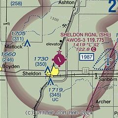
| Sectional chart |
|---|
|
| Airport distance calculator |
|---|
|
|
| Sunrise and sunset |
|---|
|
Times for 18-May-2026
| | Local
(UTC-5) | | Zulu
(UTC) |
|---|
| Morning civil twilight | | 05:24 | | 10:24 |
| Sunrise | | 05:57 | | 10:57 |
| Sunset | | 20:42 | | 01:42 |
| Evening civil twilight | | 21:15 | | 02:15 |
|
| Current date and time |
|---|
| Zulu (UTC) | 19-May-2026 00:05:03 |
|---|
| Local (UTC-5) | 18-May-2026 19:05:03 |
|---|
|
| METAR |
|---|
| KSHL | 182355Z AUTO 01013KT 3SM -RA SCT005 BKN012 13/13 A2971 RMK AO2 P0005
|
KSXK
20nm SW | 182355Z AUTO 02013KT 6SM BR OVC005 13/13 A2972 RMK AO2 P0002
|
|
| TAF |
|---|
KFSD
46nm NW | 181941Z 1820/1918 36010KT P6SM OVC012 FM182100 01012KT 3SM -SHRA BR OVC009 FM190200 35015G23KT P6SM VCSH OVC007 FM190900 32016G24KT P6SM OVC007 FM191000 33015G24KT P6SM OVC011 FM191700 32016G24KT P6SM BKN027
|
|
| NOTAMs |
|---|
NOTAMs are issued by the DoD/FAA and will open in a separate window not controlled by AirNav.
|
|

