FAA INFORMATION EFFECTIVE 14 MAY 2026
Location
| FAA Identifier: | EUF |
| Lat/Long: | 31-57-04.7000N 085-07-44.1000W
31-57.078333N 085-07.735000W
31.9513056,-85.1289167
(estimated) |
| Elevation: | 285.2 ft. / 86.9 m (surveyed) |
| Variation: | 04W (2010) |
| From city: | 3 miles N of EUFAULA, AL |
| Time zone: | UTC -5 (UTC -6 during Standard Time) |
| Zip code: | 36027 |
Airport Operations
| Airport use: | Open to the public |
| Control tower: | no |
| ARTCC: | ATLANTA CENTER |
| FSS: | ANNISTON FLIGHT SERVICE STATION |
| NOTAMs facility: | ANB (NOTAM-D service available) |
| Attendance: | MON- FRI 0800-1700, ALL SAT-SUN 0830-1500
MON- FRI
FOR SVC AFT HRS CALL 334-695-0285. |
| Wind indicator: | lighted |
| Segmented circle: | yes |
| Lights: | DUSK-2200. AFTER 2200, ACTVT PAPI RWYS 18 & 36; MIRL RWY 18/36 - CTAF. |
| Beacon: | white-green (lighted land airport)
Operates sunset to sunrise. |
Airport Communications
| CTAF/UNICOM: | 122.8 |
| WX ASOS: | 128.325 (334-232-0003) |
| ATLANTA APPROACH: | 125.5 126.55 ;7000 FT & ABV |
| ATLANTA DEPARTURE: | 125.5 126.55 ;7000 FT & ABV |
| CLEARANCE DELIVERY: | 134.25 |
- APCH/DEP SVC PRVDD BY ATLANTA LARGE TRACON 125.5 (0515-2200) OTHER TIMES ATLANTA ARTCC 120.45/298.850 (COLUMBUS RCAG)
- CLNC DEL PRVDD BY ATLANTA LARGE TRACON 134.25 (0515-2200) OTHER TIMES ATLANTA ARTCC 120.45/298.850 (COLUMBUS RCAG).
Nearby radio navigation aids
| VOR radial/distance | | VOR name | | Freq | | Var |
|---|
| EUF at field | | EUFAULA VOR/DME | | 109.20 | | 02E |
| LSFr202/23.9 | | LAWSON VOR/DME | | 111.40 | | 05W |
Airport Services
| Fuel available: | 100LL JET-A+ |
| Parking: | hangars and tiedowns |
| Airframe service: | NONE |
| Powerplant service: | NONE |
| Bottled oxygen: | NONE |
| Bulk oxygen: | NONE |
Runway Information
Runway 18/36
| Dimensions: | 5000 x 100 ft. / 1524 x 30 m |
| Surface: | asphalt, in good condition |
| Weight bearing capacity: | |
| Runway edge lights: | medium intensity |
| RUNWAY 18 | | RUNWAY 36 |
| Latitude: | 31-57.490630N | | 31-56.667588N |
| Longitude: | 085-07.705165W | | 085-07.766238W |
| Elevation: | 283.0 ft. | | 277.4 ft. |
| Traffic pattern: | left | | left |
| Runway heading: | 188 magnetic, 184 true | | 008 magnetic, 004 true |
| Markings: | nonprecision, in good condition | | nonprecision, in good condition |
| Visual slope indicator: | 4-light PAPI on left (3.00 degrees glide path) | | 4-light PAPI on left (3.00 degrees glide path) |
| Touchdown point: | yes, no lights | | yes, no lights |
| Obstructions: | 24 ft. tree, 314 ft. from runway, 98 ft. right of centerline, 4:1 slope to clear
CONTROLLING OBSTRUCTION EXCEEDS A 45 DEGREE SLOPE | | 26 ft. tree, 222 ft. from runway, 220 ft. right of centerline |
Airport Ownership and Management from official FAA records
| Ownership: | Publicly-owned |
| Owner: | CITY OF EUFAULA
BOX 219
EUFAULA, AL 36027
Phone 334-688-2000 |
| Manager: | NIKKI OGLETREE
1730 N. EUFALA AVE
EUFAULA, AL 36027
Phone 334-695-0285
334-695-0285 AFT HRS. |
Additional Remarks
| - | LOW FLYING HELICOPTERS IN TFC PAT. |
| - | ARPT LCTD IN WILDLIFE REFUGE - CONSTANT BIRD HAZARD. |
Instrument Procedures
NOTE: All procedures below are presented as PDF files. If you need a reader for these files, you should download the free Adobe Reader.NOT FOR NAVIGATION. Please procure official charts for flight.
FAA instrument procedures published for use from 14 May 2026 at 0901Z to 11 June 2026 at 0900Z.
IAPs - Instrument Approach Procedures |
|---|
| RNAV (GPS) RWY 18 | |
download (241KB) |
| RNAV (GPS) RWY 36 | |
download (245KB) |
| VOR/DME RWY 36 | |
download (224KB) |
| VOR RWY 18 | |
download (221KB) |
| NOTE: Special Take-Off Minimums/Departure Procedures apply | |
download (518KB) |
Other nearby airports with instrument procedures:
11A - Clayton Municipal Airport (19 nm W)
KLSF - Lawson Army Airfield (Fort Benning) (24 nm N)
KCSG - Columbus Airport (35 nm N)
KBIJ - Early County Airport (35 nm S)
KHDL - Headland Municipal Airport (36 nm S)
|
|

Road maps at:
MapQuest
Bing
Google
| Aerial photo |
|---|
WARNING: Photo may not be current or correct
 Photo by Landan Long
Photo taken 31-Jul-2018
looking northeast.
Photo by Landan Long
Photo taken 31-Jul-2018
looking northeast.
Do you have a better or more recent aerial photo of Weedon Field Airport that you would like to share? If so, please send us your photo.
|
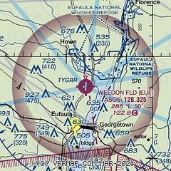
| Sectional chart |
|---|
|
| Airport distance calculator |
|---|
|
|
| Sunrise and sunset |
|---|
|
Times for 07-Jun-2026
| | Local
(UTC-5) | | Zulu
(UTC) |
|---|
| Morning civil twilight | | 05:07 | | 10:07 |
| Sunrise | | 05:35 | | 10:35 |
| Sunset | | 19:43 | | 00:43 |
| Evening civil twilight | | 20:12 | | 01:12 |
|
| Current date and time |
|---|
| Zulu (UTC) | 07-Jun-2026 06:27:58 |
|---|
| Local (UTC-5) | 07-Jun-2026 01:27:58 |
|---|
|
| METAR |
|---|
| KEUF | 070558Z AUTO 00000KT 10SM OVC070 23/22 A3002 RMK AO1 SLP162 60000 T02280217 10272 20222 403110150 50001 $
|
|
| NOTAMs |
|---|
NOTAMs are issued by the DoD/FAA and will open in a separate window not controlled by AirNav.
|
|

