FAA INFORMATION EFFECTIVE 09 JULY 2026
Location
| FAA Identifier: | FSW |
| Lat/Long: | 40-39-32.8000N 091-19-39.9000W
40-39.546667N 091-19.665000W
40.6591111,-91.3277500
(estimated) |
| Elevation: | 721.8 ft. / 220.0 m (surveyed) |
| Variation: | 00W (2010) |
| From city: | 2 miles N of FORT MADISON, IA |
| Time zone: | UTC -5 (UTC -6 during Standard Time) |
| Zip code: | 52627 |
Airport Operations
| Airport use: | Open to the public |
| Activation date: | 03/1959 |
| Control tower: | no |
| ARTCC: | CHICAGO CENTER |
| FSS: | FORT DODGE FLIGHT SERVICE STATION |
| NOTAMs facility: | FSW (NOTAM-D service available) |
| Attendance: | MON-SUN ON CALL
FOR ARPT ATTENDANCE CALL 319-316-2234 (CELL). |
| Wind indicator: | lighted |
| Segmented circle: | no |
| Lights: | ACTVT MIRL RY 17/35 & REIL RY 35 & PAPI RY 35 - CTAF. |
| Beacon: | white-green (lighted land airport)
Operates sunset to sunrise. |
Airport Communications
| CTAF/UNICOM: | 122.8 |
| WX AWOS-3: | 120.925 (319-372-5147) |
| WX ASOS at BRL (12 nm NE): | 118.025 (319-752-6246) |
| WX AWOS-3 at EOK (13 nm S): | 118.375 (319-524-7884) |
| WX AWOS-3 at MPZ (19 nm NW): | 119.325 (319-385-4926) |
- APCH/DEP SVC PRVDD BY CHICAGO ARTCC ON FREQS 135.6/316.1 (BURLINGTON RCAG).
Nearby radio navigation aids
| VOR radial/distance | | VOR name | | Freq | | Var |
|---|
| BRLr253/18.7 | | BURLINGTON VOR/DME | | 115.55 | | 05E |
| NDB name | | Hdg/Dist | | Freq | | Var | | ID |
|---|
| BURNS | | 271/9.3 | | 390 | | 01E | | BR | -... .-. |
| MACOMB | | 283/36.0 | | 251 | | 01E | | JZY | .--- --.. -.-- |
Airport Services
| Fuel available: | 100LL
100LL:SELF SERVE WITH CREDIT CARD. |
| Parking: | hangars and tiedowns |
| Airframe service: | NONE |
| Powerplant service: | NONE |
| Bottled oxygen: | NONE |
| Bulk oxygen: | NONE |
Runway Information
Runway 17/35
| Dimensions: | 4000 x 75 ft. / 1219 x 23 m |
| Surface: | concrete/wired/combed, in good condition |
| Weight bearing capacity: | | PCN 9 /R/C/W/U | | Single wheel: | 19.0 | | Double wheel: | 25.0 |
|
| Runway edge lights: | medium intensity |
| RUNWAY 17 | | RUNWAY 35 |
| Latitude: | 40-39.866987N | | 40-39.225467N |
| Longitude: | 091-19.762823W | | 091-19.566015W |
| Elevation: | 713.0 ft. | | 715.2 ft. |
| Traffic pattern: | right | | left |
| Runway heading: | 167 magnetic, 167 true | | 347 magnetic, 347 true |
| Markings: | nonprecision, in good condition | | nonprecision, in good condition |
| Visual slope indicator: | | | 2-light PAPI on left (3.00 degrees glide path)
RWY 35 PAPI UNUSBL BYD 6 DEGS LEFT OF CNTRLN AND BYD 8 DEGS RIGHT OF CNTRLN. |
| Runway end identifier lights: | | | yes |
| Touchdown point: | yes, no lights | | yes, no lights |
| Obstructions: | 40 ft. trees, 1100 ft. from runway, 225 ft. right of centerline, 22:1 slope to clear | | 13 ft. trees, 400 ft. from runway, 15:1 slope to clear
+33 FT TREES 1000 FT L/R. |
Airport Ownership and Management from official FAA records
| Ownership: | Publicly-owned |
| Owner: | CITY OF FORT MADISON
AVE E & 8 TH
FORT MADISON, IA 52627
Phone 319-372-7700
JOSH DENNING CHMN ARPT CMSN; CALL 319-470-0066. LAURA LEIGOS, CITY MANAGER - 319-372-7700 EXT 203 |
| Manager: | TIM BINGHAM
50 ARPT RD.
FORT MADISON, IA 52627
Phone 319-372-1138 |
Additional Remarks
| - | TWY LGTS AT ENTRANCE ONLY. |
| - | FOR CD CTC CHICAGO ARTCC AT 630-906-8921. |
Instrument Procedures
NOTE: All procedures below are presented as PDF files. If you need a reader for these files, you should download the free Adobe Reader.NOT FOR NAVIGATION. Please procure official charts for flight.
FAA instrument procedures published for use from 09 July 2026 at 0901Z to 06 August 2026 at 0900Z.
IAPs - Instrument Approach Procedures |
|---|
| RNAV (GPS) RWY 17 | |
download (262KB) |
| RNAV (GPS) RWY 35 | |
download (291KB) |
| NOTE: Special Alternate Minimums apply | |
download (147KB) |
| NOTE: Special Take-Off Minimums/Departure Procedures apply | |
download (158KB) |
Other nearby airports with instrument procedures:
KBRL - Southeast Iowa Regional Airport (12 nm NE)
KEOK - Keokuk Municipal Airport (13 nm S)
KMPZ - Mount Pleasant Municipal Airport (19 nm NW)
KMQB - Macomb Municipal Airport (32 nm E)
C66 - Monmouth Municipal Airport (36 nm NE)
|
|

Road maps at:
MapQuest
Bing
Google
| Aerial photo |
|---|
WARNING: Photo may not be current or correct
 Photo by Kimberly Dibble
Photo taken 15-Apr-2010
looking southwest.
Photo by Kimberly Dibble
Photo taken 15-Apr-2010
looking southwest.
Do you have a better or more recent aerial photo of Fort Madison Municipal Airport that you would like to share? If so, please send us your photo.
|
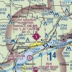
| Sectional chart |
|---|
|
| Airport distance calculator |
|---|
|
|
| Sunrise and sunset |
|---|
|
Times for 23-Jul-2026
| | Local
(UTC-5) | | Zulu
(UTC) |
|---|
| Morning civil twilight | | 05:23 | | 10:23 |
| Sunrise | | 05:55 | | 10:55 |
| Sunset | | 20:29 | | 01:29 |
| Evening civil twilight | | 21:00 | | 02:00 |
|
| Current date and time |
|---|
| Zulu (UTC) | 23-Jul-2026 06:15:08 |
|---|
| Local (UTC-5) | 23-Jul-2026 01:15:08 |
|---|
|
| METAR |
|---|
| KFSW | 230555Z AUTO 33002KT 10SM OVC046 15/15 A3015 RMK AO2 10227 20145
|
KBRL
11nm NE | 230553Z AUTO 02004KT 10SM FEW055 14/14 A3015 RMK AO2 SLP206 T01440139 10222 20144 402390144 53006
|
KEOK
12nm S | 230555Z AUTO 00000KT 10SM CLR 16/14 A3015 RMK A01
|
KMPZ
19nm NW | 230555Z AUTO 00000KT 10SM CLR 13/12 A3016 RMK AO2
|
|
| TAF |
|---|
KBRL
11nm NE | 230520Z 2306/2406 VRB04KT P6SM FEW250 FM231700 12005KT P6SM BKN050 FM240100 12004KT P6SM SCT050 BKN250
|
|
| NOTAMs |
|---|
NOTAMs are issued by the DoD/FAA and will open in a separate window not controlled by AirNav.
|
|

