FAA INFORMATION EFFECTIVE 19 MARCH 2026
Location
| FAA Identifier: | MPZ |
| Lat/Long: | 40-56-47.8040N 091-30-40.2140W
40-56.796733N 091-30.670233W
40.9466122,-91.5111706
(estimated) |
| Elevation: | 730.6 ft. / 222.7 m (surveyed) |
| Variation: | 00W (2010) |
| From city: | 3 miles SE of MOUNT PLEASANT, IA |
| Time zone: | UTC -5 (UTC -6 during Standard Time) |
| Zip code: | 52641 |
Airport Operations
| Airport use: | Open to the public |
| Activation date: | 03/1945 |
| Control tower: | no |
| ARTCC: | CHICAGO CENTER |
| FSS: | FORT DODGE FLIGHT SERVICE STATION |
| NOTAMs facility: | MPZ (NOTAM-D service available) |
| Attendance: | MON-FRI 0800-1700, ALL SAT-SUN ON-CALL
FOR ARPT ATTENDANCE ON SAT-SUN CALL 319-385-8122 |
| Wind indicator: | lighted |
| Segmented circle: | no |
| Lights: | ACTVT REIL RWY 15 & 33 ONLY WHEN MIRL OPNL; PAPI RWY 15 & 33; MIRL 15/33 - CTAF. |
| Beacon: | white-green (lighted land airport)
Operates sunset to sunrise. |
Airport Communications
| CTAF/UNICOM: | 123.05 |
| WX AWOS-3: | 119.325 (319-385-4926) |
| WX AWOS-3 at FSW (19 nm SE): | 120.925 (319-372-5147) |
- APCH/DEP SVC PRVDD BY CHICAGO ARTCC ON FREQS 135.6/316.1 (BURLINGTON RCAG).
Nearby radio navigation aids
| VOR radial/distance | | VOR name | | Freq | | Var |
|---|
| BRLr292/29.8 | | BURLINGTON VOR/DME | | 115.55 | | 05E |
| IOWr167/34.6 | | IOWA CITY VOR/DME | | 116.20 | | 05E |
Airport Services
| Fuel available: | 100LL JET-A |
| Parking: | hangars and tiedowns |
| Airframe service: | MAJOR |
| Powerplant service: | MAJOR |
| Bottled oxygen: | NONE |
| Bulk oxygen: | NONE |
Runway Information
Runway 15/33
| Dimensions: | 4001 x 75 ft. / 1220 x 23 m |
| Surface: | concrete, in excellent condition |
| Weight bearing capacity: | | Single wheel: | 12.0 | | Double wheel: | 16.0 |
|
| Runway edge lights: | medium intensity |
| RUNWAY 15 | | RUNWAY 33 |
| Latitude: | 40-57.061365N | | 40-56.477405N |
| Longitude: | 091-30.847907W | | 091-30.445470W |
| Elevation: | 725.0 ft. | | 730.2 ft. |
| Traffic pattern: | left | | right |
| Runway heading: | 152 magnetic, 152 true | | 332 magnetic, 332 true |
| Markings: | nonprecision, in good condition | | nonprecision, in good condition |
| Visual slope indicator: | 2-light PAPI on left (3.00 degrees glide path) | | 2-light PAPI on left (3.00 degrees glide path) |
| Runway end identifier lights: | yes | | yes |
| Touchdown point: | yes, no lights | | yes, no lights |
| Obstructions: | 17 ft. trees, 589 ft. from runway, 55 ft. left of centerline, 22:1 slope to clear | | 4 ft. fence, 295 ft. from runway, 23:1 slope to clear |
Runway 3/21
| Dimensions: | 1967 x 120 ft. / 600 x 37 m |
| Surface: | turf, in fair condition |
| Runway edge markings: | 03/21 CORNERS & EDGES MKD BY YELLOW CONES. |
| RUNWAY 3 | | RUNWAY 21 |
| Latitude: | 40-56.731687N | | 40-56.973043N |
| Longitude: | 091-30.860627W | | 091-30.575673W |
| Elevation: | 720.9 ft. | | 725.6 ft. |
| Traffic pattern: | left | | left |
| Runway heading: | 042 magnetic, 042 true | | 222 magnetic, 222 true |
| Touchdown point: | yes, no lights | | yes, no lights |
| Obstructions: | 15 ft. road, 670 ft. from runway, 44:1 slope to clear | | none |
Airport Ownership and Management from official FAA records
| Ownership: | Publicly-owned |
| Owner: | CITY OF MT PLEASANT
220 WEST MONROE
MT PLEASANT, IA 52641
Phone 319-385-1470 |
| Manager: | CLIFFORD BAKER
1720 SOUTH IRIS STREET
MT PLEASANT, IA 52641
Phone 319-385-8122
OR 319-385-1487. |
Additional Remarks
| - | FOR CD CTC CHICAGO ARTCC AT 630-906-8921. |
Instrument Procedures
NOTE: All procedures below are presented as PDF files. If you need a reader for these files, you should download the free Adobe Reader.NOT FOR NAVIGATION. Please procure official charts for flight.
FAA instrument procedures published for use from 19 March 2026 at 0901Z to 16 April 2026 at 0900Z.
IAPs - Instrument Approach Procedures |
|---|
| RNAV (GPS) RWY 15 | |
download (242KB) |
| RNAV (GPS) RWY 33 | |
download (259KB) |
| NOTE: Special Alternate Minimums apply | |
download (146KB) |
| NOTE: Special Take-Off Minimums/Departure Procedures apply | |
download (158KB) |
Other nearby airports with instrument procedures:
KFSW - Fort Madison Municipal Airport (19 nm SE)
KBRL - Southeast Iowa Regional Airport (20 nm SE)
KAWG - Washington Municipal Airport (21 nm N)
KFFL - Fairfield Municipal Airport (22 nm W)
KEOK - Keokuk Municipal Airport (29 nm S)
|
|

Road maps at:
MapQuest
Bing
Google
| Aerial photo |
|---|
WARNING: Photo may not be current or correct

Do you have a better or more recent aerial photo of Mount Pleasant Municipal Airport that you would like to share? If so, please send us your photo.
|
| Sectional chart |
|---|
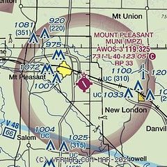
|
| Airport distance calculator |
|---|
|
|
| Sunrise and sunset |
|---|
|
Times for 04-Apr-2026
| | Local
(UTC-5) | | Zulu
(UTC) |
|---|
| Morning civil twilight | | 06:18 | | 11:18 |
| Sunrise | | 06:45 | | 11:45 |
| Sunset | | 19:33 | | 00:33 |
| Evening civil twilight | | 20:01 | | 01:01 |
|
| Current date and time |
|---|
| Zulu (UTC) | 05-Apr-2026 00:37:59 |
|---|
| Local (UTC-5) | 04-Apr-2026 19:37:59 |
|---|
|
| METAR |
|---|
| KMPZ | 050015Z AUTO 27014G21KT 10SM BKN050 06/00 A3008 RMK AO2
|
KFSW
19nm SE | 050015Z AUTO 25015G21KT 10SM SCT043 SCT050 06/M00 A3009 RMK AO2
|
|
| TAF |
|---|
KBRL
20nm SE | 041953Z 0420/0518 29013G24KT P6SM BKN035 FM050900 31012KT P6SM BKN050
|
|
| NOTAMs |
|---|
NOTAMs are issued by the DoD/FAA and will open in a separate window not controlled by AirNav.
|
|

