FAA INFORMATION EFFECTIVE 19 MARCH 2026
Location
| FAA Identifier: | GDV |
| Lat/Long: | 47-08-19.4000N 104-48-26.0000W
47-08.323333N 104-48.433333W
47.1387222,-104.8072222
(estimated) |
| Elevation: | 2458.3 ft. / 749.3 m (surveyed) |
| Variation: | 10E (2010) |
| From city: | 4 miles NW of GLENDIVE, MT |
| Time zone: | UTC -6 (UTC -7 during Standard Time) |
| Zip code: | 59330 |
Airport Operations
| Airport use: | Open to the public |
| Control tower: | no |
| ARTCC: | SALT LAKE CITY CENTER |
| FSS: | GREAT FALLS FLIGHT SERVICE STATION |
| NOTAMs facility: | GDV (NOTAM-D service available) |
| Attendance: | 0730-1830 |
| Wind indicator: | lighted |
| Segmented circle: | yes |
| Lights: | ACTIVATE MIRL RWY 02-20 AND RWY 12-30, PAPI RWY 02 AND RWY 20, REIL RWY 12 AND RWY 30 - CTAF. VASI RY 12/30 OPER CONTINUOUSLY. |
| Beacon: | white-green (lighted land airport)
Operates sunset to sunrise. |
Airport Communications
| CTAF/UNICOM: | 122.8 |
| WX AWOS-3PT: | 135.075 (406-687-3346) |
- APCH/DEP CTL SVC PRVDD BY SALT LAKE ARTCC (ZLC) ON 126.85/305.2 (WATFORD CITY RCAG).
Airport Services
| Fuel available: | 100LL JET-A+ |
| Parking: | hangars and tiedowns |
| Airframe service: | MINOR |
| Powerplant service: | MINOR |
| Bottled oxygen: | NONE |
| Bulk oxygen: | NONE |
Runway Information
Runway 12/30
| Dimensions: | 5704 x 100 ft. / 1739 x 30 m |
| Surface: | asphalt/grooved, in good condition |
| Weight bearing capacity: | | Single wheel: | 38.0 | | Double wheel: | 50.0 |
|
| Runway edge lights: | medium intensity |
| RUNWAY 12 | | RUNWAY 30 |
| Latitude: | 47-08.603682N | | 47-07.924485N |
| Longitude: | 104-48.812303W | | 104-47.863650W |
| Elevation: | 2458.3 ft. | | 2454.2 ft. |
| Traffic pattern: | left | | left |
| Runway heading: | 126 magnetic, 136 true | | 306 magnetic, 316 true |
| Declared distances: | TORA:5704 TODA:5704 ASDA:5704 LDA:5704 | | TORA:5704 TODA:5704 ASDA:5704 LDA:5704 |
| Markings: | nonprecision, in good condition | | nonprecision, in good condition |
| Visual slope indicator: | 4-box VASI on left (3.00 degrees glide path) | | 4-box VASI on left (3.00 degrees glide path) |
| Runway end identifier lights: | yes | | yes |
| Touchdown point: | yes, no lights | | yes, no lights |
Runway 2/20
| Dimensions: | 3002 x 60 ft. / 915 x 18 m |
| Surface: | asphalt, in good condition
TWY A HAS EDGE LIPS EXCEEDING 3 IN. |
| Runway edge lights: | medium intensity |
| RUNWAY 2 | | RUNWAY 20 |
| Latitude: | 47-08.236630N | | 47-08.634165N |
| Longitude: | 104-48.824662W | | 104-48.395513W |
| Elevation: | 2456.1 ft. | | 2453.8 ft. |
| Traffic pattern: | left | | left |
| Runway heading: | 026 magnetic, 036 true | | 206 magnetic, 216 true |
| Declared distances: | TORA:3002 TODA:3002 ASDA:3002 LDA:3002 | | TORA:3002 TODA:3002 ASDA:3002 LDA:3002 |
| Markings: | basic, in good condition | | basic, in good condition |
| Visual slope indicator: | 2-light PAPI on left (3.00 degrees glide path) | | 2-light PAPI on left (3.00 degrees glide path) |
| Touchdown point: | yes, no lights | | yes, no lights |
Airport Ownership and Management from official FAA records
| Ownership: | Publicly-owned |
| Owner: | DAWSON COUNTY
207 WEST BELL
GLENDIVE, MT 59330
Phone (406) 377-3058 |
| Manager: | CRAIG HOSTETLER
207 WEST BELL
GLENDIVE, MT 59330
Phone 406-989-2054
AFTER HRS CONTACT AMGR 406-989-2054. |
Additional Remarks
| - | AIRFIELD SURFACE CONDITIONS UNMONITORED 0100-1100 NOV-MAY. |
| - | FOR CD IF UNA TO CTC ON FSS FREQ, CTC SALT LAKE ARTCC AT 801-320-2568. |
Instrument Procedures
NOTE: All procedures below are presented as PDF files. If you need a reader for these files, you should download the free Adobe Reader.NOT FOR NAVIGATION. Please procure official charts for flight.
FAA instrument procedures published for use from 19 March 2026 at 0901Z to 16 April 2026 at 0900Z.
IAPs - Instrument Approach Procedures |
|---|
| RNAV (GPS) RWY 12 | |
download (244KB) |
| RNAV (GPS) RWY 30 | |
download (258KB) |
| NOTE: Special Alternate Minimums apply | |
download (171KB) |
| NOTE: Special Take-Off Minimums/Departure Procedures apply | |
download (223KB) |
Other nearby airports with instrument procedures:
4U6 - Circle Town County Airport (35 nm NW)
20U - Beach Airport (36 nm E)
KSDY - Sidney-Richland Regional Airport (42 nm NE)
KBHK - Baker Municipal Airport (53 nm SE)
PO1 - Poplar Municipal Airport (61 nm N)
|
|

Road maps at:
MapQuest
Bing
Google
| Aerial photo |
|---|
WARNING: Photo may not be current or correct
 Photo taken 01-May-2017
at about 1500' AGL looking northwest.
Photo taken 01-May-2017
at about 1500' AGL looking northwest.
Do you have a better or more recent aerial photo of Dawson Community Airport that you would like to share? If so, please send us your photo.
|
| Sectional chart |
|---|
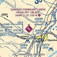
|
| Airport distance calculator |
|---|
|
|
| Sunrise and sunset |
|---|
|
Times for 20-Mar-2026
| | Local
(UTC-6) | | Zulu
(UTC) |
|---|
| Morning civil twilight | | 06:33 | | 12:33 |
| Sunrise | | 07:03 | | 13:03 |
| Sunset | | 19:10 | | 01:10 |
| Evening civil twilight | | 19:41 | | 01:41 |
|
| Current date and time |
|---|
| Zulu (UTC) | 21-Mar-2026 05:34:08 |
|---|
| Local (UTC-6) | 20-Mar-2026 23:34:08 |
|---|
|
| METAR |
|---|
KGDV
2nm SE | 210456Z AUTO 27008KT 10SM CLR 11/04 A2977 RMK AO2 SLP078 T01110044 TSNO $
|
|
| TAF |
|---|
KGDV
2nm SE | 201720Z 2018/2118 20010KT P6SM FEW120 FM202000 28014KT P6SM SCT100 FM210200 26010KT P6SM FEW130 WS020/28045KT FM211400 29008KT P6SM SCT170
|
|
| NOTAMs |
|---|
NOTAMs are issued by the DoD/FAA and will open in a separate window not controlled by AirNav.
|
|

